THIS AVALANCHE FORECAST EXPIRED ON February 9, 2014 @ 6:18 am
Avalanche Forecast published on February 8, 2014 @ 6:18 am
Issued by Brandon Schwartz - Tahoe National Forest

Near treeline and above treeline, avalanche danger is HIGH on NW-N-NE-E-SE aspects on slopes 32 degrees and steeper. For all other areas, avalanche danger is CONSIDERABLE on slopes 32 degrees and steeper. Wind slab, storm slab, wet slab, loose wet, and deep persistent slab avalanches are all possible today.

4. High

?

Above Treeline
Very dangerous avalanche conditions. Travel in avalanche terrain not recommended.

4. High

?

Near Treeline
Very dangerous avalanche conditions. Travel in avalanche terrain not recommended.

3. Considerable

?

Below Treeline
Dangerous avalanche conditions. Careful snowpack evaluation, cautious route-finding and conservative decision-making essential.
    Very dangerous avalanche conditions. Travel in avalanche terrain not recommended.
Avalanche Problem 1: Wind Slab
  • Type ?
  • Aspect/Elevation ?
  • Likelihood ?
    Certain
    Very Likely
    Likely
    Possible
    Unlikely
  • Size ?
    Historic
    Very Large
    Large
    Small

New snow and wind transport last night has further increased the size of wind slabs that existed over the past several days. Winds slabs 2 to 4+ feet or more thick now exist near treeline and above treeline on NW-N-NE-E-SE aspects. Large destructive avalanches are possible today. Some of these wind slab avalanches could take on wet slab characteristics today in areas where the slab becomes wet from rain due to rising snow levels.

Avalanche Problem 2: Storm Slab
  • Type ?
  • Aspect/Elevation ?
  • Likelihood ?
    Certain
    Very Likely
    Likely
    Possible
    Unlikely
  • Size ?
    Historic
    Very Large
    Large
    Small

New snow has deposited on top of weak layers of buried surface hoar, buried graupel, near crust facets, and/or lower density storm snow layers that are known to exist within the upper snowpack between the Jan 30 rain crust and the snow surface. Human triggered avalanches are likely and natural avalanches are possible near treeline and below treeline on NW-N-NE-E aspects above 7,000'. Warming air temperatures today will deposit higher density new snow on top of lower density new snow creating an upside-down snowpack. This will further serve to increase snowpack instability in these areas. Some of these storm slab avalanches could take on wet slab characteristics today in areas where the slab becomes wet from rain due to rising snow levels.

Avalanche Problem 3: Loose Wet
  • Type ?
  • Aspect/Elevation ?
  • Likelihood ?
    Certain
    Very Likely
    Likely
    Possible
    Unlikely
  • Size ?
    Historic
    Very Large
    Large
    Small

As snow levels continue to rise today, rain will fall on new snow. Loose wet avalanches are possible, below 7,000' to 8,000' on all aspects. Wet loose avalanches are most likely to initiate on slopes 37 degrees and steeper.

Forecast discussion

In areas above 9,500' deep persistent slabs linger near treeline and below treeline on NW-N-NE aspects. Weak layers of well developed facets and depth hoar remain buried in the snowpack in these areas and were not destroyed by rain on January 28 and 29. The likelihood of failure of these basal facets will increase as this storm cycle progresses and additional new snow load stresses the snowpack above these weak layers. Locations that are both above 9,500' and near treeline or below treeline terrain represent only a small portion of the forecast area, keeping this problem isolated in distribution.

recent observations

Observations made yesterday along the Blue Lake Road (Carson Pass area), in the Deep Creek drainage, and on Andesite Peak (Donner Summit area) all revealed unstable wind slabs. Wind slabs ranging from 4 inches to 2 feet thick were observed in wind loaded areas on NW-N-NE-E aspects in near treeline and above treeline terrain. Intentionally skier triggered avalanches occurred in Deep Creek and on Andesite Peak. These wind slabs were noted to fail on lower density layers of snow between the base of the wind slab and the top of the prominent January 30 rain crust. The exact failure layers of these avalanches and other observed unstable winds slabs varied from one location to another. Near crust facets, buried surface hoar, and simple lower density layers of storm snow associated with rising snow levels over the past few days are all likely culprits. Blowing snow at the sites of the noted instabilities made exact snow crystal type very difficult to identify

Weather and CURRENT CONDITIONS
weather summary

A major pacific storm system continues to impact the forecast area. Snow levels are on the rise, currently up to around 7,000' to 7,500' at this time. New snow accumulations above 7,500' of 9 to 15 inches have occurred over the past 24 hours. Between one half and two thirds of the new snow accumulation occurred last night. High intensity precipitation is expected to continue for most areas through noon today before easing in intensity and continuing. An additional 6 to 12 inches of new snow is forecast to accumulate above 8,000' today. Precipitation intensity is forecast in increase again tonight through Sunday. Ridgetop winds remain strong out of the southwest with ridgetop gusts over the Sierra Crest recorded up to 78 mph.

CONDITIONS ALONG THE SIERRA CREST BETWEEN 8200 FT. AND 9200 FT. IN THE LAST 24 HOURS
6am temperature: 27 to 29 deg. F.
Max. temperature: 27 to 29 deg. F.
Average ridgetop wind direction: Southwest
Average ridgetop wind speed: 55 mph
Maximum ridgetop wind gust: 78 mph
New snowfall: 9 to 15 inches
Total snow depth: 27 to 49 inches
Two-Day Mountain Weather Forecast Produced in partnership with the Reno NWS
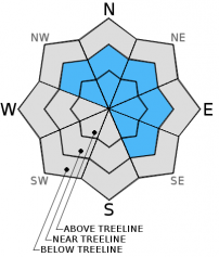
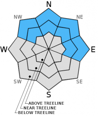
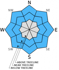
For 7000 ft. to 8000 ft.
Saturday Saturday Night Sunday
Weather: Cloudy skies with rain and snow. Cloudy skies with rain and snow. Cloudy skies with rain and snow.
Temperatures: 33 to 38 deg. F. 30 to 35 deg. F. 33 to 38 deg. F.
Mid Slope Winds: Southwest Southwest Southwest
Wind Speed: 20 to 30 mph with gusts to 50 mph. 25 to 35 mph with gusts to 50 mph. 25 to 35 mph. Gusts to 45 mph increasing to 55 mph in the afternoon.
Expected snowfall: Up to 2 0 to 2 Up to 2
For 8000 ft. to 9000 ft.
Saturday Saturday Night Sunday
Weather: Cloudy skies with snow. Rain may mix with snow below 8,500' Cloudy skies with snow. Rain may mix with snow below 8,500' Cloudy skies with snow. Rain may mix with snow below 8,500'
Temperatures: 28 to 34 deg. F. 26 to 32 deg. F. 33 to 40 deg. F.
Ridge Top Winds: Southwest Southwest Southwest
Wind Speed: 45 to 55 mph with gusts to 85 mph. 45 to 55 mph with gusts to 80 mph. 35 to 45 mph with gusts to 65 mph.
Expected snowfall: 6 to 12 8 to 16 6 to 12
Disclaimer

This avalanche advisory is provided through a partnership between the Tahoe National Forest and the Sierra Avalanche Center. This advisory covers the Central Sierra Nevada Mountains between Yuba Pass on the north and Ebbetts Pass on the south. Click here for a map of the forecast area. This advisory applies only to backcountry areas outside established ski area boundaries. This advisory describes general avalanche conditions and local variations always occur. This advisory expires 24 hours after the posted time unless otherwise noted. The information in this advisory is provided by the USDA Forest Service who is solely responsible for its content.