THIS AVALANCHE FORECAST EXPIRED ON February 16, 2014 @ 6:42 am
Avalanche Forecast published on February 15, 2014 @ 6:42 am
Issued by Brandon Schwartz - Tahoe National Forest

Avalanche danger is LOW for all elevations and aspects. Normal caution is advised. Insolated areas of instability may exist near and above treeline in complex or extreme terrain.

1. Low

?

Above Treeline
Generally safe avalanche conditions. Watch for unstable snow on isolated terrain features.

1. Low

?

Near Treeline
Generally safe avalanche conditions. Watch for unstable snow on isolated terrain features.

1. Low

?

Below Treeline
Generally safe avalanche conditions. Watch for unstable snow on isolated terrain features.
    Generally safe avalanche conditions. Watch for unstable snow on isolated terrain features.
Avalanche Problem 1: Normal Caution
  • Type ?
  • Aspect/Elevation ?
  • Likelihood ?
    Certain
    Very Likely
    Likely
    Possible
    Unlikely
  • Size ?
    Historic
    Very Large
    Large
    Small

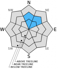
Finding a lingering unstable wind slab is unlikely but not impossible today, especially in complex or extreme terrain. The most likely location for any continued instability is in near or above treeline terrain on a N to NE aspect. Evidence of any snowpack instability will be difficult to find outside of a snowpit. Stack the odds in favor of survival by exposing only one person at a time to avalanche terrain. Travel from one well established (not marginal) island of safety to the next when moving into and out of avalanche terrain.

recent observations

Observations made yesterday on Peak 9,773' (Mount Rose backcountry) and on road cuts along the Blue Lakes Road (Carson Pass area) both indicated stable snowpack conditions. Settlement and strength gains continue to occur within both the recent storm snow and basal facet layers. Well above freezing air temperatures over the past few days and areas of rain/mist on Feb 13 created a shallow layer of wet surface snow in most areas. Some refreeze of the snow surface has begun.

Windward areas are now well scoured. There is no longer any snow available for continued wind transport and subsequent wind loading. Wind slabs that formed on Feb 12 still exist, but have had time to increase bonding to the snow layer below.

Weather and CURRENT CONDITIONS
weather summary

A significant wind event is forecast to impact the region this afternoon into tomorrow morning ahead of an approaching cold front. Strong southwest ridgetop winds over the past 72 hours are forecast to increase to gale force this afternoon with ridgetop gusts to 115 mph. Ridgetop winds will further increase tonight with average speeds of 90 to 95 mph and gusts to 140 mph. Above freezing air temperatures below 9,700' this morning are forecast to cool as the day progresses. Precipitation is expected to begin this evening. Snow level is expected to start out around 7,000' before falling to near 5,000' overnight. New snow amounts of 3 to 6 inches are forecast along the Sierra Crest by Sunday morning.

CONDITIONS ALONG THE SIERRA CREST BETWEEN 8200 FT. AND 9200 FT. IN THE LAST 24 HOURS
6am temperature: 35 to 42 deg. F.
Max. temperature: 38 to 48 deg. F.
Average ridgetop wind direction: Southwest
Average ridgetop wind speed: 42 mph
Maximum ridgetop wind gust: 57 mph
New snowfall: 0 inches
Total snow depth: 40 to 50 inches
Two-Day Mountain Weather Forecast Produced in partnership with the Reno NWS
For 7000 ft. to 8000 ft.
Saturday Saturday Night Sunday
Weather: Mostly cloudy skies. Cloudy skies with a chance of rain and snow in the evening. Rain and snow after midnight. Mostly cloudy skies becoming partly cloudy. Snow showers in the morning. A slight chance of snow showers in the afternoon.
Temperatures: 44 to 51 deg. F. 25 to 30 deg. F. 34 to 41 deg. F.
Mid Slope Winds: Southwest Southwest Southwest
Wind Speed: 30 to 45 mph with gusts to 65 mph, increasing to 40 to 55 mph with gust to 85 mph in the afternoon. 50 to 65 mph with gusts to 90 mph. 30 to 45 mph with gusts to 65 mph, decreasing to 20 to 30 mph with gusts to 45 mph in the afternoon.
Expected snowfall: 0 3 to 6 Up to 3
For 8000 ft. to 9000 ft.
Saturday Saturday Night Sunday
Weather: Mostly cloudy skies. Cloudy skies with a chance of snow in the evening. Snow after midnight. Mostly cloudy skies becoming partly cloudy. Snow showers in the morning. A slight chance of snow showers in the afternoon.
Temperatures: 38 to 44 deg. F. 20 to 27 deg. F. 30 to 38 deg. F.
Ridge Top Winds: Southwest Southwest Southwest
Wind Speed: 55 to 65 mph with gusts to 95 mph, increasing to 65 to 75 mph with gusts to 115 mph in the afternoon. 90 to 95 mph with gusts to 140 mph, decreasing to 75 to 80 mph with gusts to 120 mph after midnight. 60 to 65 mph with gusts to 95 mph, decreasing to 35 to 40 mph with gusts to 60 mph in the afternoon.
Expected snowfall: 0 3 to 6 Up to 3
Disclaimer

This avalanche advisory is provided through a partnership between the Tahoe National Forest and the Sierra Avalanche Center. This advisory covers the Central Sierra Nevada Mountains between Yuba Pass on the north and Ebbetts Pass on the south. Click here for a map of the forecast area. This advisory applies only to backcountry areas outside established ski area boundaries. This advisory describes general avalanche conditions and local variations always occur. This advisory expires 24 hours after the posted time unless otherwise noted. The information in this advisory is provided by the USDA Forest Service who is solely responsible for its content.