


For 7000 ft. to 8000 ft.
| Tuesday | Tuesday Night | Wednesday | |
|---|---|---|---|
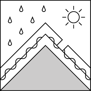
| Weather: | Mostly cloudy skies. | Mostly cloudy skies with a slight chance of showers after midnight. | Mostly cloudy skies becoming cloudy. A slight chance of rain in the morning. A chance of rain in the afternoon. |
| Temperatures: | 40 to 46 deg. F. | 26 to 33 deg. F. | 42 to 49 deg. F. |
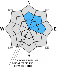
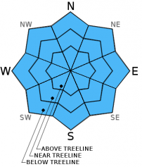
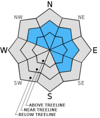
| Mid Slope Winds: | West | Southwest | Southwest |
| Wind Speed: | Light winds. | Light winds increasing to 10 to 15 mph with gusts to 25 mph after midnight. | 15 to 20 mph with gusts to 30 mph, increasing to 25 to 30 mph with gusts to 45 mph in the afternoon. |
| Expected snowfall: | 0 | 0 to trace | 0 |
For 8000 ft. to 9000 ft.
| Tuesday | Tuesday Night | Wednesday | |
|---|---|---|---|
| Weather: | Mostly cloudy skies. | Mostly cloudy skies with a slight chance of snow showers after midnight. | Mostly cloudy skies becoming cloudy. A slight chance of rain and snow. |
| Temperatures: | 39 to 46 deg. F. | 25 to 32 deg. F. | 36 to 43 deg. F. |
| Ridge Top Winds: | West | Southeast shifting to southwest after midnight. | Southwest |
| Wind Speed: | 10 to 15 mph with gusts to 25 mph in the morning, becoming light. | 10 to 15 mph shifting and increasing to 20 to 25 mph with gusts to 35 mph after midnight. | 20 to 25 mph with gusts to 40 mph, increasing to 40 to 45 mph with gusts to 70 mph in the afternoon. |
| Expected snowfall: | 0 | 0 to trace | 0 to trace |


