THIS AVALANCHE FORECAST EXPIRED ON March 12, 2014 @ 6:54 am
Avalanche Forecast published on March 11, 2014 @ 6:54 am
Issued by Brandon Schwartz - Tahoe National Forest

Avalanche danger is LOW for all elevations and aspects. Please keep in mind that LOW danger does not equal no danger. Isolated areas of small wind slab and small wet loose instability may be encountered today on slopes 35 degrees and steeper.

1. Low

?

Above Treeline
Generally safe avalanche conditions. Watch for unstable snow on isolated terrain features.

1. Low

?

Near Treeline
Generally safe avalanche conditions. Watch for unstable snow on isolated terrain features.

1. Low

?

Below Treeline
Generally safe avalanche conditions. Watch for unstable snow on isolated terrain features.
    Generally safe avalanche conditions. Watch for unstable snow on isolated terrain features.
Avalanche Problem 1: Loose Wet
  • Type ?
  • Aspect/Elevation ?
  • Likelihood ?
    Certain
    Very Likely
    Likely
    Possible
    Unlikely
  • Size ?
    Historic
    Very Large
    Large
    Small

That vast majority of loose wet instablity associated with the recent new snow is expected to have occured yesterday while the bond between the new snow and the underlying rain crust was weaker. Colder air temperatures today are expected to keep areas of loose wet snow instability to a minimum.

Avalanche Problem 2: Wind Slab
  • Type ?
  • Aspect/Elevation ?
  • Likelihood ?
    Certain
    Very Likely
    Likely
    Possible
    Unlikely
  • Size ?
    Historic
    Very Large
    Large
    Small

Unstable wind slabs that existed in some areas yesterday morning on N-NE-E aspects have been scoured by the wind shift from SW to NE last night. Redistribution of wind slabs from N-NE-E aspects to SE-S-SW-W-NW aspects has occurred. These new wind slabs are not expected to pose a significant threat to backcountry travelers at less than 1 foot deep and extending only a very short distance down slope. High consequence terrain such as areas above cliff bands and terrain traps could magnify the consequences of an avalanche that would otherwise be too small to bury or injure a person.

recent observations

Observations made yesterday on Waterhouse Peak (Luther Pass area) and on Andesite Ridge (Donner Summit area) reveled significantly different amounts of snowpack instability associated with wind slabs during the morning hours. While no evidence of instability was observed in wind loaded N aspect areas along the summit ridge of Waterhouse Peak, on Andesite Ridge two small natural avalanches were observed above treeline on NE-E aspects at 7,800' to 8,400'. In both areas wind slab depth was noted at 4 to 12 inches. By 1 pm, formal and informal stability test indicated that wind slab instability had decreased significantly.

With cloud cover clearing to sunny skies much faster than forecast, wet snow instability was subsequently much more widespread than anticipated to occur with a forecast of the mostly cloudy skies through sunset. During the afternoon hours on Andesite Ridge, rapid warming was noted and natural and human triggered loose wet avalanches became widespread. The rain crust at the base of the new snow provided an efficient bed surface for avalanches large enough to injure a person to run full path. Human triggered wet loose avalanche activity was noted on all aspects on slopes over 30 degrees in slope angle below the ridge highpoint of 8,400'.

Weather and CURRENT CONDITIONS
weather summary

Yesterday's cold front moved through much earlier in the day and cloud cover cleared much faster than forecast following frontal passage. As a result, significantly more incoming solar radiation was observed and maximum daytime air temperatures exceeded forecast values by 5 degrees at the upper elevations. A low pressure system passing by to the east of the forecast area will provide cold air, east winds, and sunny skies across the region today. Ridgetop winds shifted from southwest to northeast overnight and are moderate in speed this morning. Wind speeds are forecast to further increase this afternoon and tonight, continuing through tomorrow. Maximum daytime air temperatures are forecast to reach the mid 20s to mid 30s today for areas above 7,000'.

CONDITIONS ALONG THE SIERRA CREST BETWEEN 8200 FT. AND 9200 FT. IN THE LAST 24 HOURS
6am temperature: 22 to 24 deg. F.
Max. temperature: 32 to 42 deg. F.
Average ridgetop wind direction: Southwest shifting to northeast
Average ridgetop wind speed: 30 mph
Maximum ridgetop wind gust: 58 mph
New snowfall: 2 to 4 inches
Total snow depth: 43 to 53 inches
Two-Day Mountain Weather Forecast Produced in partnership with the Reno NWS
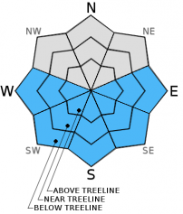
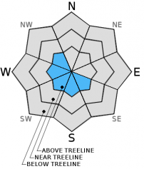
For 7000 ft. to 8000 ft.
Tuesday Tuesday Night Wednesday
Weather: Sunny skies. Clear skies. Sunny skies.
Temperatures: 30 to 38 deg. F. 18 to 22 deg. F. 38 to 42 deg. F.
Mid Slope Winds: East East East
Wind Speed: 15 to 20 mph increasing to 25 to 30 mph in the afternoon. Gusts to 40 mph. 20 to 30 mph with gusts to 45 mph. 15 to 25 mph with gusts to 35 mph.
Expected snowfall: 0 0 0
For 8000 ft. to 9000 ft.
Tuesday Tuesday Night Wednesday
Weather: Sunny skies. Clear skies. Sunny skies.
Temperatures: 25 to 32 deg. F. 16 to 22 deg. F. 31 to 38 deg. F.
Ridge Top Winds: East East East
Wind Speed: 35 to 45 mph with gusts to 65 mph. 45 to 55 mph. Gusts to 75 mph increasing to 90 mph after midnight. 35 to 45 mph. Gusts to 75 mph decreasing to 55 mph in the afternoon.
Expected snowfall: 0 0 0
Disclaimer

This avalanche advisory is provided through a partnership between the Tahoe National Forest and the Sierra Avalanche Center. This advisory covers the Central Sierra Nevada Mountains between Yuba Pass on the north and Ebbetts Pass on the south. Click here for a map of the forecast area. This advisory applies only to backcountry areas outside established ski area boundaries. This advisory describes general avalanche conditions and local variations always occur. This advisory expires 24 hours after the posted time unless otherwise noted. The information in this advisory is provided by the USDA Forest Service who is solely responsible for its content.