THIS AVALANCHE FORECAST EXPIRED ON March 25, 2014 @ 6:54 am
Avalanche Forecast published on March 24, 2014 @ 6:54 am
Issued by Andy Anderson - Tahoe National Forest - Sierra Avalanche Center

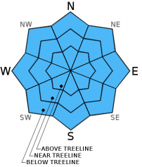
The avalanche danger should remain LOW for all elevations and aspects today. Continue to use normal caution when traveling in the backcountry. A winter storm expected to impact the region Tuesday night and Wednesday will cause the avalanche danger to increase as it delivers snow and wind to the area.

1. Low

?

Above Treeline
Generally safe avalanche conditions. Watch for unstable snow on isolated terrain features.

1. Low

?

Near Treeline
Generally safe avalanche conditions. Watch for unstable snow on isolated terrain features.

1. Low

?

Below Treeline
Generally safe avalanche conditions. Watch for unstable snow on isolated terrain features.
    Generally safe avalanche conditions. Watch for unstable snow on isolated terrain features.
Avalanche Problem 1: Normal Caution
  • Type ?
  • Aspect/Elevation ?
  • Likelihood ?
    Certain
    Very Likely
    Likely
    Possible
    Unlikely
  • Size ?
    Historic
    Very Large
    Large
    Small

Overnight temperatures near and below freezing and clear skies should have allowed another strong refreeze last night. Sun and warm temperatures today will again allow soft wet corn snow to form on the surface on the E-SE-S-SW-W aspects.  Despite this warming, wet snow instability should remain unlikely due to the strong refreeze and the drainage pathways established by a myriad of rain events and melt-freeze cycles this winter. If any human triggered loose wet snow instabilities such as roller balls or tiny loose wet avalanches do occur they should not involve enough snow to cause problems for backcountry travelers.

recent observations

Yesterday observations on Mt. Judah remained consistent with the data taken from other areas during the last 10 days. By noon up to 2 inches of soft corn snow existed above a supportable snowpack consisting of mostly melt-freeze snow on the E-SE-S aspects. Similar conditions existed on the SW-W aspects where snow remained. On many of the SW-W aspects melting had exposed large areas of bare ground. The northerly aspects remained frozen and exhibited no signs of instability.

Weather and CURRENT CONDITIONS
weather summary

Expect one more day of sunny, warm, spring-like weather today with highs in the upper 40's and low 50's above 7000 ft. The winds should begin to shift to the southwest ahead of a winter storm approaching the region. The wind should continue to increase tomorrow with gusts near 100 mph along the Sierra Crest by tomorrow afternoon. Cloud cover should also begin to increase throughout the day tomorrow. By Tuesday afternoon some rain and snow showers could begin to occur. The bulk of the snow and wind associated with this storm should occur Tuesday night and Wednesday. Snow levels should start around 7000 ft. on Tuesday evening before falling to 4500 ft. on Wednesday morning. Check in with the NWS in Reno for more details concerning this storm.

CONDITIONS ALONG THE SIERRA CREST BETWEEN 8200 FT. AND 9200 FT. IN THE LAST 24 HOURS
6am temperature: 28 to 39 deg. F.
Max. temperature: 46 to 50 deg. F.
Average ridgetop wind direction: East and Southeast
Average ridgetop wind speed: 10 to 15 mph
Maximum ridgetop wind gust: 30 mph
New snowfall: 0 inches
Total snow depth: 33 to 43 inches
Two-Day Mountain Weather Forecast Produced in partnership with the Reno NWS
For 7000 ft. to 8000 ft.
Monday Monday Night Tuesday
Weather: Sunny Clear Partly cloudy in the morning becoming mostly cloudy with a chance of rain and snow showers in the afternoon. Snow levels between 7000 and 8000 ft.
Temperatures: 50 to 56 deg. F. 30 to 35 deg. F. 38 to 48 deg. F.
Mid Slope Winds: Southeast shifting to the southwest in the afternoon Southwest Southwest
Wind Speed: 10 mph increasing to 10 to 15 mph in the afternoon 10 to 15 mph increasing to 15 to 20 mph with gusts to 35 mph after midnight 15 to 25 mph with gusts to 40 mph increasing to 25 to 35 mph with gusts to 55 mph in the afternoon
Expected snowfall: 0 0 up to 1
For 8000 ft. to 9000 ft.
Monday Monday Night Tuesday
Weather: Sunny Clear Partly cloudy in the morning becoming mostly cloudy with a chance of snow showers in the afternoon
Temperatures: 44 to 50 deg. F. 25 to 35 deg. F. 31 to 38 deg. F.
Ridge Top Winds: Southeast shifting to the southwest in the afternoon Southwest Southwest
Wind Speed: 10 mph increasing to 10 to 15 mph with gusts to 25 mph in the afternoon 20 to 30 mph with gusts to 55 mph after midnight 40 to 55 mph with gusts to 80 mph increasing to 55 to 65 mph with gusts 90 to 110 mph in the afternoon
Expected snowfall: 0 0 up to 2
Disclaimer

This avalanche advisory is provided through a partnership between the Tahoe National Forest and the Sierra Avalanche Center. This advisory covers the Central Sierra Nevada Mountains between Yuba Pass on the north and Ebbetts Pass on the south. Click here for a map of the forecast area. This advisory applies only to backcountry areas outside established ski area boundaries. This advisory describes general avalanche conditions and local variations always occur. This advisory expires 24 hours after the posted time unless otherwise noted. The information in this advisory is provided by the USDA Forest Service who is solely responsible for its content.