


For 7000 ft. to 8000 ft.
| Thursday | Thursday Night | Friday | |
|---|---|---|---|
| Weather: | Cloudy skies becoming mostly cloudy. Scatteres snow showers. | Mostly cloudy skies with a chance of snow showers. | Cloudy skies with a slight chance of snow showers. |
| Temperatures: | 29 to 36 deg. F. | 20 to 27 deg. F. | 35 to 42 deg. F. |
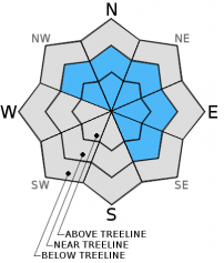
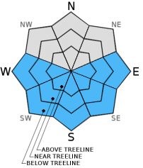
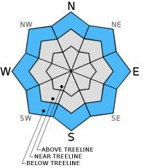
| Mid Slope Winds: | Southwest | Southwest | Southwest |
| Wind Speed: | 25 to 35 mph with gusts to 50 mph, decreasing to 15 to 20 mph with gusts to 35 mph in the afternoon. | 15 to 20 mph with gusts to 35 mph. | 15 to 25 mph with gusts to 35 mph. |
| Expected snowfall: | Trace to 1 | Trace | 0 to trace |
For 8000 ft. to 9000 ft.
| Thursday | Thursday Night | Friday | |
|---|---|---|---|
| Weather: | Cloudy skies becoming mostly cloudy. Scatteres snow showers. | Mostly cloudy skies with a chance of snow showers. | Cloudy skies with a slight chance of snow showers. |
| Temperatures: | 24 to 31 deg. F. | 19 to 24 deg. F. | 30 to 35 deg. F. |
| Ridge Top Winds: | West | Southwest | Southwest |
| Wind Speed: | 40 to 55 mph with gusts 60 to 80 mph, decreasing to 30 to 40 mph with gusts to 55 mph in the afternoon. | 30 to 40 mph with gusts to 55 mph, decreasing to 20 to 30 mph with gusts to 45 mph after midnight. | 20 to 30 mph with gusts to 45 mph. |
| Expected snowfall: | Trace to 2 | Trace | 0 to trace |


