THIS AVALANCHE FORECAST EXPIRED ON December 7, 2014 @ 7:00 am
Avalanche Forecast published on December 6, 2014 @ 7:00 am
Issued by Andy Anderson - Tahoe National Forest - Sierra Avalanche Center

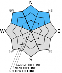
Above 9000 ft. in below, near, and above treeline terrain, human-triggered avalanches may remain possible on some NW-N-NE aspects due to persistent slabs on slopes 34 degrees and steeper. Pockets of MODERATE avalanche danger exist in these areas. Higher elevation northerly facing slopes with the most snow represent the most likely places to find persistent slabs and the places where people want to recreate. Don't let early season excitement overrule good judgment and decision making.

2. Moderate

?

Above Treeline
Heightened avalanche conditions on specific terrain features. Evaluate snow and terrain carefully; identify features of concern.

2. Moderate

?

Near Treeline
Heightened avalanche conditions on specific terrain features. Evaluate snow and terrain carefully; identify features of concern.

2. Moderate

?

Below Treeline
Heightened avalanche conditions on specific terrain features. Evaluate snow and terrain carefully; identify features of concern.
    Heightened avalanche conditions on specific terrain features. Evaluate snow and terrain carefully; identify features of concern.
Avalanche Problem 1: Persistent Slab
  • Type ?
  • Aspect/Elevation ?
  • Likelihood ?
    Certain
    Very Likely
    Likely
    Possible
    Unlikely
  • Size ?
    Historic
    Very Large
    Large
    Small

Even though no avalanche activity has occurred on the Dec. 2 facets, some snowpit tests on northerly aspects above 9000 ft. continue to indicate that if this layer breaks the resulting fracture can propagate along the persistent weak layer. Variability associated with where this layer exists, how weak it is, and how continuous it is increases the uncertainty surrounding this avalanche problem. Digging a quick pit can tell whether or not the facets exist at a specific location, but that data may not apply to the next slope over or even to a different part of the same slope.

Variability plus uncertainty plus persistent slabs makes conservative terrain selection and decision making essential. While many people may get lucky on a slope, that does not mean everyone will. On slopes where this weak layer exists and is continuous enough, one trigger point is all it takes for a person to start a fracture that could result in a large dangerous avalanche. Before committing to a line on NW-N-NE aspects above 9000 ft. evaluate the snowpack, terrain, and consequences carefully. Remember that observations like slope cuts and previous tracks do not indicate stability when dealing with persistent slabs. A slope breaking to the ground often represents the only warning this avalanche problem gives. Avoiding areas where these layers might exist or sticking to lower angle slopes without steeper terrain above them are the only mitigation options for persistent slabs.

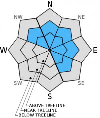
Avalanche Problem 2: Wind Slab
  • Type ?
  • Aspect/Elevation ?
  • Likelihood ?
    Certain
    Very Likely
    Likely
    Possible
    Unlikely
  • Size ?
    Historic
    Very Large
    Large
    Small

Triggering a wind slab avalanche has become unlikely but not impossible. Isolated human triggerable wind slabs may linger on slopes above cliffs, in gullies or couloirs, or in other complex or extreme terrain. Wind slabs avalanches on slopes above 9000 ft. where the Dec. 2nd facet layer still exists could step down into those layers as well.

recent observations

Yesterday in the Mt. Rose backcountry observations from Relay Peak and Tamarack Peak both showed continued settlement and consolidation in the recent snow. Snowpit tests, ski cuts on test slopes, hand pits, and general observations did not reveal any signs of instability associated with the recent snow or lingering wind slabs. Snow depth in these areas ranged from 50 to 90 cm. 

On the other hand, snowpit data, hand pits, and probing all revealed that the Dec. 2nd facets still exist on the northerly aspects above 9200 ft. This layer varied in thickness, hardness, and in how well developed the facets were. Tests on this layer also provided inconsistent results. Some tests indicated that fracture propagation through this layer has become unlikely; however, the majority of tests showed that fractures can still travel along this persistent weak layer (videos).

Below 8000 ft. snow cover remains limited.

Weather and CURRENT CONDITIONS
weather summary

Last night's storm brought another .2 to .7 inches of water to the forecast area. Since snow levels remained between 7900 and 8200 ft. that precipitation fell as rain below 8200 ft. Above 8200 ft. 1 to 3 inches of heavy wet snow accumulated. Scattered showers should linger over the forecast area today as the small storm departs the region. Cloud cover and winds should decrease through tonight before starting to increase again tomorrow ahead of another weak storm. The forecast calls for temperatures to remain warmer than normal with daytime highs in the upper 30's to mid 40's between 7000 and 8000 ft. and mid to upper 30's above 8000 ft.

CONDITIONS ALONG THE SIERRA CREST BETWEEN 8200 FT. AND 9200 FT. IN THE LAST 24 HOURS
6am temperature: 31 to 35 deg. F.
Max. temperature: 38 to 41 deg. F.
Average ridgetop wind direction: Southwest
Average ridgetop wind speed: 25 to 30 mph
Maximum ridgetop wind gust: 61 mph
New snowfall: 1 to 3 inches
Total snow depth: 13 to 30 inches
Two-Day Mountain Weather Forecast Produced in partnership with the Reno NWS
For 7000 ft. to 8000 ft.
Saturday Saturday Night Sunday
Weather: Mostly cloudy with scattered showers. Snow level 7800 to 8200 ft. Partly cloudy becoming mostly cloudy Mostly cloudy
Temperatures: 38 to 44 deg. F. 23 to 30 deg. F. 38 to 45 deg. F.
Mid Slope Winds: Southwest Southwest Southwest
Wind Speed: 15 to 25 mph with gusts to 35 mph 10 to 15 mph decreasing during the night Light increasing to 15 to 20 mph with gusts to 30 mph in the afternoon
Expected snowfall: up to 1 0 0
For 8000 ft. to 9000 ft.
Saturday Saturday Night Sunday
Weather: Mostly cloudy with scattered snow showers. Snow level 7800 to 8200 ft. Partly cloudy becoming mostly cloudy Mostly cloudy
Temperatures: 30 to 37 deg. F. 23 to 30 deg. F. 34 to 41 deg. F.
Ridge Top Winds: Southwest Southwest Southwest
Wind Speed: 40 to 45 mph with gusts to 65 mph decreasing to 30 to 35 mph with gusts to 50 mph in the afternoon 15 to 25 mph with gusts to 35 mph 20 to 30 mph with gusts to 35 mph increasing to 45 mph in the afternoon
Expected snowfall: up to 1 0 0
Disclaimer

This avalanche advisory is provided through a partnership between the Tahoe National Forest and the Sierra Avalanche Center. This advisory covers the Central Sierra Nevada Mountains between Yuba Pass on the north and Ebbetts Pass on the south. Click here for a map of the forecast area. This advisory applies only to backcountry areas outside established ski area boundaries. This advisory describes general avalanche conditions and local variations always occur. This advisory expires 24 hours after the posted time unless otherwise noted. The information in this advisory is provided by the USDA Forest Service who is solely responsible for its content.