THIS AVALANCHE FORECAST EXPIRED ON December 14, 2014 @ 6:54 am
Avalanche Forecast published on December 13, 2014 @ 6:54 am
Issued by Brandon Schwartz - Tahoe National Forest

Near and above treeline, pockets of MODERATE danger exist along the Sierra Crest on NW-N-NE-E-SE aspects on slopes 35 degrees and steeper due to lingering wind slabs. For all other areas, avalanche danger is LOW.

2. Moderate

?

Above Treeline
Heightened avalanche conditions on specific terrain features. Evaluate snow and terrain carefully; identify features of concern.

2. Moderate

?

Near Treeline
Heightened avalanche conditions on specific terrain features. Evaluate snow and terrain carefully; identify features of concern.

1. Low

?

Below Treeline
Generally safe avalanche conditions. Watch for unstable snow on isolated terrain features.
    Heightened avalanche conditions on specific terrain features. Evaluate snow and terrain carefully; identify features of concern.
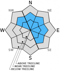
Avalanche Problem 1: Wind Slab
  • Type ?
  • Aspect/Elevation ?
  • Likelihood ?
    Certain
    Very Likely
    Likely
    Possible
    Unlikely
  • Size ?
    Historic
    Very Large
    Large
    Small

Pockets of unstable wind slab are expected to linger mainly along the Sierra Crest in near treeline and above treeline terrain on NW-N-NE-E-SE aspects. Triggering these wind slabs will likely be more difficult today than yesterday. Traveling on thin portions of the slab near trigger points such as exposed rocks or on slopes previously undercut by ski/snowmobile tracks will increase the likelihood of causing an avalanche. Very little evidence of instability is expected to exist in the backcountry today. Do not allow a lack of instability clues to lead to lazy or half hearted backcounty travel techniques. Anyone caught in an avalanche today will most likely be taken by surprise. Act like a pro by traveling one at time in avalanche terrain and moving from one high quality island of safety to the next.

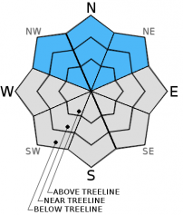
Avalanche Problem 2: Deep Slab
  • Type ?
  • Aspect/Elevation ?
  • Likelihood ?
    Certain
    Very Likely
    Likely
    Possible
    Unlikely
  • Size ?
    Historic
    Very Large
    Large
    Small

Direct triggering of a deep persistent slab by a person on snowmobile, snowboard, or skies is very unlikely at this time. Above 9,000' to 9,500' on NW-N-NE aspects, a small amount of concern remains for the possibility of a triggered wind slab avalanche that creates sufficient force to collapse the weak layer of basal facets below. This would cause a large and destructive step down type avalanche event, involving nearly all of the existing snowpack. There is no mitigation technique for this avalanche problem, only avoidance. When evaluating northerly aspect slopes on the highest elevation peaks, consider the consequences of a large avalanche and do not let the call of fresh tracks cloud judgment.

recent observations

Observations made yesterday in the Donner Summit, Ward Canyon, Carson Pass, and Mount Rose areas revealed storm snow totals of 12 to 24 inches along the Sierra Crest and 3 to 4 inches along the east side of Lake Tahoe. Travel in the above listed areas created isolated to frequent skier triggered cracking in wind loaded areas. Evidence of a recent natural avalanche was observed on Red Lake Peak (Carson Pass area). This avalanche occurred in near treeline terrain on a N aspect around 8,900' (more info). Snowpack failure was noted as occurring on a layer of lower density storm snow beneath higher density wind slab. This weak layer was observed along the Sierra Crest around 1 foot deep between 8,000' and 9,000' and in the Mount Rose area around 6 inches deep.

Weather and CURRENT CONDITIONS
weather summary

A break in the weather will occur today as weak high pressure builds over the region. Partial clearing will lead to mostly to partly cloudy skies by this afternoon. Light ridgetop winds are forecast for today, increasing to moderate in speed tonight and tomorrow. Remote sensors are reporting air temperatures between 8,000' and 9,000' in the low 20s this morning. Maximum daytime air temperatures are expected to reach the mid 20s to low 30s today for areas above 7,000'. A chance of light snowfall returns to the forecast area Sunday afternoon and Monday.

CONDITIONS ALONG THE SIERRA CREST BETWEEN 8200 FT. AND 9200 FT. IN THE LAST 24 HOURS
6am temperature: 21 to 24 deg. F.
Max. temperature: 27 to 32 deg. F.
Average ridgetop wind direction: Southwest
Average ridgetop wind speed: 19 mph
Maximum ridgetop wind gust: 31 mph
New snowfall: Trace to 2 inches
Total snow depth: 22 to 37 inches
Two-Day Mountain Weather Forecast Produced in partnership with the Reno NWS
For 7000 ft. to 8000 ft.
Saturday Saturday Night Sunday
Weather: Mostly cloudy skies, becoming partly cloudy. Partly cloudy skies. Mostly cloudy skies. A slight chance of snow showers in the afternoon.
Temperatures: 26 to 33 deg. F. 20 to 24 deg. F. 31 to 37 deg. F.
Mid Slope Winds: N NW shifting to S after midnight. S
Wind Speed: Light winds Light winds Light winds increasing to 10 to 15 mph in the afternoon.
Expected snowfall: 0 0 0 to trace
For 8000 ft. to 9000 ft.
Saturday Saturday Night Sunday
Weather: Mostly cloudy skies, becoming partly cloudy. Partly cloudy skies. Mostly cloudy skies. A slight chance of snow showers in the afternoon.
Temperatures: 23 to 28 deg. F. 15 to 22 deg. F. 25 to 32 deg. F.
Ridge Top Winds: N NW shifting to S after midnight. SW
Wind Speed: Light winds increasing to 10 to 15 mph in the afternoon. 10 to 15 mph with gusts to 25 mph. 10 to 15 mph with gusts to 25 mph, increasing to 20 to 25 mph with gusts to 35 mph in the afternoon.
Expected snowfall: 0 0 0 to trace
Disclaimer

This avalanche advisory is provided through a partnership between the Tahoe National Forest and the Sierra Avalanche Center. This advisory covers the Central Sierra Nevada Mountains between Yuba Pass on the north and Ebbetts Pass on the south. Click here for a map of the forecast area. This advisory applies only to backcountry areas outside established ski area boundaries. This advisory describes general avalanche conditions and local variations always occur. This advisory expires 24 hours after the posted time unless otherwise noted. The information in this advisory is provided by the USDA Forest Service who is solely responsible for its content.