THIS AVALANCHE FORECAST EXPIRED ON January 29, 2015 @ 6:45 am
Avalanche Forecast published on January 28, 2015 @ 6:45 am
Issued by Andy Anderson - Tahoe National Forest - Sierra Avalanche Center

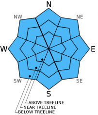
The avalanche danger should remain LOW today on all aspects and elevations. LOW danger does not mean no danger and unlikely does not mean impossible. Some small, shallow, isolated areas of unstable snow could lurk on isolated terrain features. Continue to practice safe travel habits and thoughtful decision making when traveling in the backcountry.

1. Low

?

Above Treeline
Generally safe avalanche conditions. Watch for unstable snow on isolated terrain features.

1. Low

?

Near Treeline
Generally safe avalanche conditions. Watch for unstable snow on isolated terrain features.

1. Low

?

Below Treeline
Generally safe avalanche conditions. Watch for unstable snow on isolated terrain features.
    Generally safe avalanche conditions. Watch for unstable snow on isolated terrain features.
Avalanche Problem 1: Normal Caution
  • Type ?
  • Aspect/Elevation ?
  • Likelihood ?
    Certain
    Very Likely
    Likely
    Possible
    Unlikely
  • Size ?
    Historic
    Very Large
    Large
    Small

Observations indicated that yesterday's light winds and 2 to 3 inches of snow did not create significant slabs on top of the old snow surfaces. Data also indicated that the new snow seemed to bond well to the old snow surfaces. As this new snow continues to bond and settle today, significant avalanche activity will remain unlikely. The light to moderate NE winds will also reduce the depth of snow on some of the slopes that did experience light wind loading yesterday making any small, isolated wind slabs that did form even more scarce today. Unlikely does not mean impossible. In some of the isolated areas south of Highway 50 where more snow fell, some small, shallow, and isolated wind slabs may have formed on slopes that typically experience the most wind loading. These should not extend very far down slope nor should they be very deep or widespread. Similar to yesterday some minor sluffing involving the new snow may occur on steep slopes, but these sluffs should remain small and isolated. Overall these small, isolated, and unlikely issues should not pose much hazard to backcountry travelers unless they occur in areas that magnify the consequences of any size avalanche or where a stumble or fall can have serious consequences.

recent observations

Observations from Andesite Ridge yesterday, showed new snow sitting on top of frozen crusts. The 2 inches of new snow seemed to bond well to the old snow surfaces in this area. On one steep, open slope near the summit of Andesite Ridge a ski cut triggered a very small inconsequential sluff that involved the 1-2 inches of new snow and did not run very far down slope. Significant wind loading had not occurred in areas that typically experience heavy wind loading on Andesite Ridge and observations did not reveal any significant wind slabs. In these wind loaded areas snow amounts only increased by 1-2 inches creating 2-4 inch deep drifts. Father south on Carson Pass near Carson Spur an observer reported up to 5 inches of new snow in some areas with more like 3 inches in most places. Observations in this area still indicated good bonding between the new snow and the old snow surfaces.

Weather and CURRENT CONDITIONS
weather summary

Yesterday's small system brought 2 to 3 inches of snow to the mountains above 7000 ft. Some isolated areas south of Highway 50 reported closer 4 inches. Most of the winds associated with this storm remained in the 10 to 20 mph range with a few gusts in the upper 30's. Skies started to clear some yesterday evening and overnight as the system departed. Expect mostly sunny skies today with some lingering clouds passing through the area. The winds shifted to the northeast and started to decrease during the night. These winds should continue to decrease over the next 36 hours. The unsettled partly to mostly cloudy weather should continue through tomorrow. Daytime temperatures should remain in mid 30's to low 40's above 7000 ft. with overnight lows in the mid to upper 20's.

CONDITIONS ALONG THE SIERRA CREST BETWEEN 8200 FT. AND 9200 FT. IN THE LAST 24 HOURS
6am temperature: 25 to 32 deg. F.
Max. temperature: 28 to 35 deg. F.
Average ridgetop wind direction: Southwest shifting to the northeast
Average ridgetop wind speed: 10 to 20 mph
Maximum ridgetop wind gust: 37 mph
New snowfall: 2 to 3 inches
Total snow depth: 24 to 33 inches
Two-Day Mountain Weather Forecast Produced in partnership with the Reno NWS
For 7000 ft. to 8000 ft.
Wednesday Wednesday Night Thursday
Weather: Mostly sunny to partly cloudy Mostly cloudy Mostly cloudy with a slight chance of showers
Temperatures: 36 to 43 deg. F. 23 to 30 deg. F. 36 to 43 deg. F.
Mid Slope Winds: Variable Variable Variable
Wind Speed: Light Light Light
Expected snowfall: 0 0 0
For 8000 ft. to 9000 ft.
Wednesday Wednesday Night Thursday
Weather: Mostly sunny to partly cloudy Mostly cloudy Mostly cloudy with a slight chance of showers
Temperatures: 35 to 41 deg. F. 23 to 30 deg. F. 36 to 42 deg. F.
Ridge Top Winds: Northeast Variable Variable
Wind Speed: 10 to 20 mph decreasing in the afternoon Light Light
Expected snowfall: 0 0 0
Disclaimer

This avalanche advisory is provided through a partnership between the Tahoe National Forest and the Sierra Avalanche Center. This advisory covers the Central Sierra Nevada Mountains between Yuba Pass on the north and Ebbetts Pass on the south. Click here for a map of the forecast area. This advisory applies only to backcountry areas outside established ski area boundaries. This advisory describes general avalanche conditions and local variations always occur. This advisory expires 24 hours after the posted time unless otherwise noted. The information in this advisory is provided by the USDA Forest Service who is solely responsible for its content.