THIS AVALANCHE FORECAST EXPIRED ON February 10, 2015 @ 6:55 am
Avalanche Forecast published on February 9, 2015 @ 6:55 am
Issued by Andy Anderson - Tahoe National Forest - Sierra Avalanche Center

Human triggered avalanches remain possible today. Above 8,000 ft, MODERATE avalanche danger exists on all aspects on slopes 35 degrees and steeper due to the presence of dense wind slabs, storm slabs, and wet snow. If the dense slabs do break, they could break above the person who triggers them and result in avalanches large enough to bury a person. Don't let the new snow lead to careless decision making.

2. Moderate

?

Above Treeline
Heightened avalanche conditions on specific terrain features. Evaluate snow and terrain carefully; identify features of concern.

2. Moderate

?

Near Treeline
Heightened avalanche conditions on specific terrain features. Evaluate snow and terrain carefully; identify features of concern.

2. Moderate

?

Below Treeline
Heightened avalanche conditions on specific terrain features. Evaluate snow and terrain carefully; identify features of concern.
    Heightened avalanche conditions on specific terrain features. Evaluate snow and terrain carefully; identify features of concern.
Avalanche Problem 1: Wind Slab
  • Type ?
  • Aspect/Elevation ?
  • Likelihood ?
    Certain
    Very Likely
    Likely
    Possible
    Unlikely
  • Size ?
    Historic
    Very Large
    Large
    Small

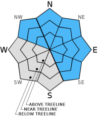
Additional snow accompanied by strong SW winds should have created more wind slabs on wind loaded and cross loaded NW-N-NE-E-SE aspects. The largest of these wind slabs will exist above 8500 ft. in near and above treeline terrain where more new snow has accumulated. In these areas wind slabs could measure more than 3 to 4 ft. in depth. The new wind slabs have formed above previous wind slabs. On northerly aspects some of these now large wind slabs sit on top of old crusts that have a layer of softer snow below them. Some wind slabs could still linger in isolated areas in below treeline terrain or in more sheltered areas due to the strong winds during this series of storms.

Human triggered avalanches involving these winds slabs remains possible. These dense and hard wind slabs can break above the person who triggers them or could be triggered by the 2nd, 3rd, 4th, or nth person on the slope. Typical obvious clues of instability and other tests may not provide reliable data as to whether or not these wind slabs will break. Wind loaded slopes steeper than 35 degrees above 8500 ft, represent the most likely places to find unstable wind slabs. Wind loaded slopes 38 degrees and steeper, couliors, unsupported slopes above cliffs, or slopes in complex or extreme terrain could be especially problematic today. Some of these slabs could fail on or just below the old snow surfaces and could propagate along those old snow layers.

Avalanche Problem 2: Storm Slab
  • Type ?
  • Aspect/Elevation ?
  • Likelihood ?
    Certain
    Very Likely
    Likely
    Possible
    Unlikely
  • Size ?
    Historic
    Very Large
    Large
    Small

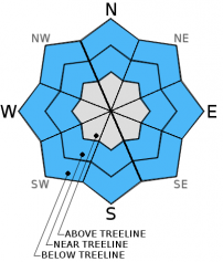
Since yesterday's snowfall started off with a short period of slightly colder snow and then warmed up, a layer of softer new snow may still exist below the heavier new snow that fell later in the storm. This upside down storm snow layering means that some unstable storm slabs may exist in wind protected areas above 8,500 ft. Human triggered storm slab avalanches will be possible on slopes steeper than 35 degrees today in wind protected areas in both near and below treeline terrain. Due to the wet snow that exists in many areas some of these storm slabs may have wet snow characteristics as well. If these do fail, they should mostly just involve the new snow, but it is not impossible that some of these slabs could fail on or just below the old snow surfaces on some steep northerly aspects above 9000 ft.

Avalanche Problem 3: Loose Wet
  • Type ?
  • Aspect/Elevation ?
  • Likelihood ?
    Certain
    Very Likely
    Likely
    Possible
    Unlikely
  • Size ?
    Historic
    Very Large
    Large
    Small

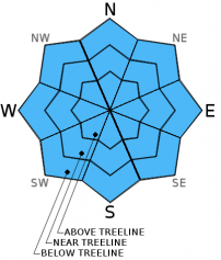
Even though temperatures have gotten colder, wet snow will still remain just below the surface on all aspects below 8500 ft. due to the copious amounts of rain that have fallen over the last several days. It will take some time for this wet snow to refreeze, and some loose wet snow instabilities will remain possible until the snow does refreeze.

recent observations

Yesterday on Tamarack Peak, 17 to 21 in. of dense recent snow existed above the old crusts with a layer of softer snow around the crusts in some areas on N-NE aspects. Snowpit tests targeting this layer on N-NE facing slopes between 9200 ft. and the summit of Tamarack (9875 ft.) indicated that it would be difficult to trigger a fracture in this softer layer below the new snow, but that if a fracture did start it may be able to travel through the layer. Some snowpit tests targeting the same layer near Carson Pass showed unstable results while other nearby tests showed stable results. Above these older snow layers, observations in both locations indicated that the new dense snow continues to consolidate. As temperatures warmed up during the afternoon, rain started falling on the snow up to at least 8800 ft. in both areas. On steep north facing slopes on Chickadee Ridge several roller balls started to occur as the day warmed up.

Weather and CURRENT CONDITIONS
weather summary

Snow levels remained above 8000 ft. for longer than forecasted allowing most of the 2+ inches of precipitation received in the last 24 hours to fall as rain below 8500 ft. The snow level did start to fall during the night, and since then 2 to 5 inches of snow has accumulated between 7000 and 8500 ft. Above 8500 ft. remote sensors report that 8 to 14 inches of heavy snow has fallen since yesterday morning. Currently, snow levels are hovering around 6500 ft. Snow showers and moderate to strong southwest winds should continue through this morning. Colder temperatures should linger across the forecast area today and tonight with daytime highs in the low 30's and overnight lows in the 20's in the mountains. As the storm moves farther away from the region this afternoon and tonight, snow showers should cease and the winds should decease dramatically. By tomorrow the forecast calls for light winds, partly cloudy skies, and slightly warmer temperatures with daytime highs in the mid to upper 30's above 7000 ft. 

CONDITIONS ALONG THE SIERRA CREST BETWEEN 8200 FT. AND 9200 FT. IN THE LAST 24 HOURS
6am temperature: 27 to 32 deg. F.
Max. temperature: 31 to 40 deg. F.
Average ridgetop wind direction: Southwest
Average ridgetop wind speed: 45 mph
Maximum ridgetop wind gust: 101 mph
New snowfall: below 8500 ft: 2 to 5 inches | above 8500 ft: 8 to 14 inches
Total snow depth: 32 to 56 inches
Two-Day Mountain Weather Forecast Produced in partnership with the Reno NWS
For 7000 ft. to 8000 ft.
Monday Monday Night Tuesday
Weather: Cloudy with snow showers in the morning becoming mostly cloudy with a chance of snow showers in the afternoon Mostly cloudy with a slight chance of snow showers in the evening becoming partly cloudy Partly cloudy
Temperatures: 31 to 38 deg. F. 21 to 28 deg. F. 35 to 42 deg. F.
Mid Slope Winds: Southwest Southwest Variable
Wind Speed: 15 to 20 mph with gusts to 30 mph 10 to 15 mph with gusts to 25 in the evening decreasing overnight Light
Expected snowfall: 1 to 4 0 0
For 8000 ft. to 9000 ft.
Monday Monday Night Tuesday
Weather: Cloudy with snow showers in the morning becoming mostly cloudy with a chance of snow showers in the afternoon Mostly cloudy with a slight chance of snow showers in the evening becoming partly cloudy Partly cloudy
Temperatures: 27 to 34 deg. F. 18 to 25 deg. F. 32 to 39 deg. F.
Ridge Top Winds: Southwest Southwest Southeast
Wind Speed: 40 to 45 mph with gusts to 70 mph decreasing to 30 to 35 mph with gusts to 55 mph in the afternoon 35 to 40 mph with gusts to 60 mph decreasing to 10 to 15 mph after midnight 5 to 10 mph increasing to 10 to 15 mph with gusts to 25 mph in the afternoon
Expected snowfall: 1 to 4 0 0
Disclaimer

This avalanche advisory is provided through a partnership between the Tahoe National Forest and the Sierra Avalanche Center. This advisory covers the Central Sierra Nevada Mountains between Yuba Pass on the north and Ebbetts Pass on the south. Click here for a map of the forecast area. This advisory applies only to backcountry areas outside established ski area boundaries. This advisory describes general avalanche conditions and local variations always occur. This advisory expires 24 hours after the posted time unless otherwise noted. The information in this advisory is provided by the USDA Forest Service who is solely responsible for its content.