THIS AVALANCHE FORECAST EXPIRED ON March 8, 2015 @ 7:52 am
Avalanche Forecast published on March 7, 2015 @ 6:52 am
Issued by Brandon Schwartz - Tahoe National Forest

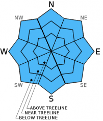
Avalanche danger remains LOW for all elevations and aspects. Small loose wet or loose dry avalanches could occur in isolated areas. Normal caution is advised.

1. Low

?

Above Treeline
Generally safe avalanche conditions. Watch for unstable snow on isolated terrain features.

1. Low

?

Near Treeline
Generally safe avalanche conditions. Watch for unstable snow on isolated terrain features.

1. Low

?

Below Treeline
Generally safe avalanche conditions. Watch for unstable snow on isolated terrain features.
    Generally safe avalanche conditions. Watch for unstable snow on isolated terrain features.
Avalanche Problem 1: Normal Caution
  • Type ?
  • Aspect/Elevation ?
  • Likelihood ?
    Certain
    Very Likely
    Likely
    Possible
    Unlikely
  • Size ?
    Historic
    Very Large
    Large
    Small

Isolated small avalanches remain possible today on all aspects on slopes 37 degrees and steeper. Avalanche character is expected to take the form of either loose wet or loose dry depending on aspect. Sun exposed areas on E-SE-S-SW-W aspects hold the greatest potential for loose wet instability in response to daytime warming. Snow from the recent storm on these aspects remains transitional in many areas and is not yet fully assimilated with the older melt-freeze snow below it. The majority of instability is expected to take the form of human triggered roller balls and pinwheels. Many areas below 7,500' on SE-S-SW aspects have melted out to bare ground since the last storm. As air temperatures continue to warm, wet surface snow will continue to form on all but the most shaded northerly aspects.

recent observations

Observations made yesterday on Rubicon Peak (West Shore Tahoe area) indicated that recent storm snow in shaded areas on northerly aspects remains cold, unconsolidated, and has yet to undergo a melt-freeze cycle. No evidence of instability was observed in the area. Snowpit data collected near treeline at 9,000' on a NNW aspect indicated that old near crust facets and buried near surface facets are rounding and gaining strength. A new layer of near surface facets is forming at the snow surface, but is not problematic at this time. Snow coverage on NW-N-NE aspects in the area is decent to good above 8,000', but quickly becomes poor to unskiable below 7,800'. Minor amounts of surface wet snow in a transitional state from recent storm snow to melt-freeze was observed on E-SE aspects at ~9,100' at mid day. Ski cuts on several test slopes 35-40 degrees in slope angle did not create any loose wet sluffs. Looking out from Rubicon Peak towards general SE-S-SW aspects around the northern half of the Lake Tahoe Basin shows large areas of bare ground on SE-S-SW aspects below 7,500'.

Weather and CURRENT CONDITIONS
weather summary

High pressure is firmly in place over the forecast area. The daily warming trend will continue today. Some thin high cloud cover is possible this afternoon, but will have little effect on incoming solar radiation. Remote sensors are reporting air temperatures in the low to mid 30s this morning for areas 8,000' to 9,600'. Inversion conditions have air temperatures on the mountain valley floors in the 20s this morning. Maximum daytime air temperatures are expected to reach the mid 40s to mid 50s today for areas above 7,000'. Ridgetop winds remain out of the east this morning and are moderate in speed. Winds are forecast to become light as the day progresses. Similar conditions are forecast for Sunday.

CONDITIONS ALONG THE SIERRA CREST BETWEEN 8200 FT. AND 9200 FT. IN THE LAST 24 HOURS
6am temperature: 30 to 37 deg. F.
Max. temperature: 42 to 49 deg. F.
Average ridgetop wind direction: East
Average ridgetop wind speed: 26 mph
Maximum ridgetop wind gust: 37 mph
New snowfall: 0 inches
Total snow depth: 33 to 47 inches
Two-Day Mountain Weather Forecast Produced in partnership with the Reno NWS
For 7000 ft. to 8000 ft.
Saturday Saturday Night Sunday
Weather: Sunny skies. Clear skies. Sunny skies.
Temperatures: 50 to 57 deg. F. 28 to 34 deg. F. 50 to 57 deg. F.
Mid Slope Winds: East East East
Wind Speed: Light winds Light winds Light winds
Expected snowfall: 0 0 0
For 8000 ft. to 9000 ft.
Saturday Saturday Night Sunday
Weather: Sunny skies. Clear skies. Sunny skies.
Temperatures: 42 to 49 deg. F. 26 to 32 deg. F. 42 to 49 deg. F.
Ridge Top Winds: East East East
Wind Speed: Light winds Light winds Light winds
Expected snowfall: 0 0 0
Disclaimer

This avalanche advisory is provided through a partnership between the Tahoe National Forest and the Sierra Avalanche Center. This advisory covers the Central Sierra Nevada Mountains between Yuba Pass on the north and Ebbetts Pass on the south. Click here for a map of the forecast area. This advisory applies only to backcountry areas outside established ski area boundaries. This advisory describes general avalanche conditions and local variations always occur. This advisory expires 24 hours after the posted time unless otherwise noted. The information in this advisory is provided by the USDA Forest Service who is solely responsible for its content.