THIS AVALANCHE FORECAST EXPIRED ON March 12, 2015 @ 7:00 am
Avalanche Forecast published on March 11, 2015 @ 7:00 am
Issued by Andy Anderson - Tahoe National Forest - Sierra Avalanche Center

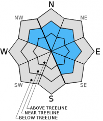
Avalanche danger should remain LOW for all elevations and aspects today since snowfall amounts should remain minimal. Some shallow, small, isolated winds slabs that do not hold enough snow to do much more than knock a person off balance may form on the most heavily wind loaded NW-N-NE-E-SE aspects near ridge lines. Continue to use normal caution when traveling in the backcountry.

1. Low

?

Above Treeline
Generally safe avalanche conditions. Watch for unstable snow on isolated terrain features.

1. Low

?

Near Treeline
Generally safe avalanche conditions. Watch for unstable snow on isolated terrain features.

1. Low

?

Below Treeline
Generally safe avalanche conditions. Watch for unstable snow on isolated terrain features.
    Generally safe avalanche conditions. Watch for unstable snow on isolated terrain features.
Avalanche Problem 1: Wind Slab
  • Type ?
  • Aspect/Elevation ?
  • Likelihood ?
    Certain
    Very Likely
    Likely
    Possible
    Unlikely
  • Size ?
    Historic
    Very Large
    Large
    Small

In most areas, data indicates that the current snowpack should have the strength needed to support the meager amount of new snow (up to 3 inches) expected to fall today. Some small isolated wind slabs may form on the most heavily wind loaded slopes due to the combination of strong southwest wind and new snow. Since new snow amounts should remain minimal, the wind slabs that do form should remain shallow, isolated, and they should not extend more than a few feet down slope. These isolated small wind slabs should not involve enough snow to bury a person, but they could push someone off course or knock a person over. Mixed rain and snow below 7500 ft. may also allow some small wet loose snow instabilities like roller balls or pinwheels to form on any lower elevation aspects that hold snow.

recent observations

Yesterday observations on Rubicon Peak showed soft, cold, unconsolidated snow on the north aspects above 7900 ft. and frozen sun crusts and melt freeze crusts on other aspects during the morning hours. By midday yesterday areas of wet sticky snow formed all aspects when the crusts melted away. As the cloud cover moved in, the north aspects started to warm up, and some wet sticky snow formed on them as well. Ski cuts on steep north facing aspects started to trigger some small pinwheels by 1:30 pm. Other than these pinwheels, snowpit tests, ski cuts, and general observations did not reveal any signs of instabilities.

Weather and CURRENT CONDITIONS
weather summary

A small storm started to impact the forecast area early this morning. Remote sensors and webcams indicated a trace of new snow that fell between 5 and 6 am above 6500 ft. Snow levels should start around 6500 ft. this morning then quickly rise to between 7000 and 7500 ft. by midday. Above 7500 ft. the forecast calls for the precipitation to continue with up to 3 inches of new snow today and up to another inch tonight before the snow starts to taper off. Areas along the Sierra Crest north of I-80 should see the most precipitation. The southwest winds will remain strong today and daytime highs should remain in the 30's above 7000 ft. today. As the snow showers taper off tonight, expect the winds to decrease and shift to the east. By tomorrow the forecast calls for partly cloudy to mostly sunny skies and daytime highs warming back up into the 40's above 7000 ft.

CONDITIONS ALONG THE SIERRA CREST BETWEEN 8200 FT. AND 9200 FT. IN THE LAST 24 HOURS
6am temperature: 30 to 38 deg. F.
Max. temperature: 45 to 52 deg. F.
Average ridgetop wind direction: Southwest
Average ridgetop wind speed: 20 to 30 mph
Maximum ridgetop wind gust: 62 mph
New snowfall: trace to 0 inches
Total snow depth: 26 to 44 inches
Two-Day Mountain Weather Forecast Produced in partnership with the Reno NWS
For 7000 ft. to 8000 ft.
Wednesday Wednesday Night Thursday
Weather: Cloudy with rain and snow Mostly cloudy becoming partly cloudy. Scattered snow showers in the evening Partly cloudy becoming sunny
Temperatures: 35 to 40 deg. F. 26 to 31 deg. F. 41 to 46 deg. F.
Mid Slope Winds: Southwest Southwest East
Wind Speed: 15 to 30 mph with gusts to 40 mph 10 to 20 mph with gusts to 30 mph in the evening becoming light during the night 10 to 15 mph with gusts to 25 mph in the afternoon
Expected snowfall: up to 3 up to 1 0
For 8000 ft. to 9000 ft.
Wednesday Wednesday Night Thursday
Weather: Cloudy with snow Mostly cloudy becoming partly cloudy. Scattered snow showers in the evening Partly cloudy becoming sunny
Temperatures: 30 to 35 deg. F. 23 to 30 deg. F. 38 to 43 deg. F.
Ridge Top Winds: Southwest Southwest shifting to north East
Wind Speed: 30 to 45 mph with gusts to 70 mph 25 to 30 mph with gusts to 45 mph decreasing to 10 to 15 mph with gusts to 30 mph after midnight 15 to 25 mph with gusts to 40 mph
Expected snowfall: 1 to 3 up to 1 0
Disclaimer

This avalanche advisory is provided through a partnership between the Tahoe National Forest and the Sierra Avalanche Center. This advisory covers the Central Sierra Nevada Mountains between Yuba Pass on the north and Ebbetts Pass on the south. Click here for a map of the forecast area. This advisory applies only to backcountry areas outside established ski area boundaries. This advisory describes general avalanche conditions and local variations always occur. This advisory expires 24 hours after the posted time unless otherwise noted. The information in this advisory is provided by the USDA Forest Service who is solely responsible for its content.