THIS AVALANCHE FORECAST EXPIRED ON March 16, 2015 @ 6:43 am
Avalanche Forecast published on March 15, 2015 @ 6:43 am
Issued by Brandon Schwartz - Tahoe National Forest

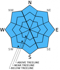
Avalanche danger remains MODERATE for all elevations and aspects on slopes 37 degrees and steeper due to another suspected poor overnight snow surface refreeze and subsequent loose wet avalanche concerns. Continuous snow cover on SE-S-SW-W aspects sufficient to allow for avalanche activity exists only in isolated areas.

2. Moderate

?

Above Treeline
Heightened avalanche conditions on specific terrain features. Evaluate snow and terrain carefully; identify features of concern.

2. Moderate

?

Near Treeline
Heightened avalanche conditions on specific terrain features. Evaluate snow and terrain carefully; identify features of concern.

2. Moderate

?

Below Treeline
Heightened avalanche conditions on specific terrain features. Evaluate snow and terrain carefully; identify features of concern.
    Heightened avalanche conditions on specific terrain features. Evaluate snow and terrain carefully; identify features of concern.
Avalanche Problem 1: Loose Wet
  • Type ?
  • Aspect/Elevation ?
  • Likelihood ?
    Certain
    Very Likely
    Likely
    Possible
    Unlikely
  • Size ?
    Historic
    Very Large
    Large
    Small

A second night of cloud cover and well above freezing air temperatures is once again expected to have allowed for a poor to nonexistent overnight snow surface refreeze. In areas where breaks in cloud cover allowed for a short window of radiational cooling, any snow surface refreeze that did form is expected to be superficial, thin, and weak. As daytime warming progresses, areas of wet surface snow will become widespread in the vast majority of areas. The lack of snow cover remaining on most SE-S-SW-W aspects will limit instability that forms today on those aspects to the isolated areas of continuous snow cover. Of the NW-N-NE-E aspects with continuous snow cover, E aspects will hold the greatest amount of wet snow with carry over from yesterday and the day before that did not refreeze last night. Potentially more problematic areas of wet snow will exist on NW-N-NE aspects where the snowpack remains more transitional with less previous melt-freeze. Human triggered loose wet avalanches are possible today on slopes 37 degrees and steeper. Keep in mind that secondary terrain hazards such as cliffs and terrain traps below hold the potential to greatly magnify consequences of an avalanche that would otherwise be too small to bury or injure a person.

recent observations

Observations made yesterday on Tamarack Peak (Mount Rose area) revealed that cloud cover and above freezing air temperatures overnight had allowed for only a minimal, weak overnight snow surface refreeze to occur. Boot penetration of 8 inches into wet snow was observed in non-compacted areas at the trailhead at 8,600' at 9:45 am. Previously compacted areas of traditional skin track placement and heavily trafficked slopes such as Hourglass and Proletariat were much more supportable than the vast majority of lesser trafficked surrounding areas. Ski cuts on the Far East Ridge of Tamarack Peak (N aspect, 9,100') produced small amounts of roller balls and pinwheels that reached up to 18 inches in diameter at 11:30 am. An upper snowpack structure of 2 to 4 inches of surface wet snow over old snow not yet affected by melt-freeze was noted in many areas on northerly aspects, including the Far East Ridge. Well established melt-freeze conditions were noted on the aspects that generally receive more sun exposure.

Weather and CURRENT CONDITIONS
weather summary

Moisture continues to stream by to the north of the forecast area. Another round of cloud cover and above average air temperatures is expected for today. Southwest winds that were slow to increase in speed yesterday have done so this morning with strong ridgetop winds forecast for today. Overnight cloud cover has air temperatures well above freezing again this morning. Remote sensors are reporting air temperatures in the mid 40s between 7,000' and 9,600' just prior to sunrise. Increasing southwest winds have mixed out any inversion with air temperatures on the mountain valley floors in the upper 40s to low 50s. Maximum daytime air temperatures are forecast to reach the mid 40s to upper 50s today for areas above 7,000'. Similar conditions are expected for tomorrow with gradually decreasing winds.

CONDITIONS ALONG THE SIERRA CREST BETWEEN 8200 FT. AND 9200 FT. IN THE LAST 24 HOURS
6am temperature: 42 to 46 deg. F.
Max. temperature: 52 to 56 deg. F.
Average ridgetop wind direction: Southwest
Average ridgetop wind speed: 23 mph
Maximum ridgetop wind gust: 61 mph
New snowfall: 0 inches
Total snow depth: 23 to 43 inches
Two-Day Mountain Weather Forecast Produced in partnership with the Reno NWS
For 7000 ft. to 8000 ft.
Sunday Sunday Night Monday
Weather: Mostly cloudy skies. Mostly cloudy skies. Mostly cloudy skies.
Temperatures: 52 to 58 deg. F. 29 to 36 deg. F. 52 to 58 deg. F.
Mid Slope Winds: SW SW SW
Wind Speed: 25 to 35 mph with gusts to 55 mph. 30 to 35 mph with gusts to 55 mph, decreasing to 15 to 25 mph with gusts to 35 mph after midnight. 15 to 20 mph with gusts to 30 mph.
Expected snowfall: 0 0 0
For 8000 ft. to 9000 ft.
Sunday Sunday Night Monday
Weather: Mostly cloudy skies. Mostly cloudy skies. Mostly cloudy skies.
Temperatures: 45 to 51 deg. F. 29 to 36 deg. F. 42 to 49 deg. F.
Ridge Top Winds: SW SW SW
Wind Speed: 45 to 55 mph with gusts to 75 mph. 55 to 60 mph with gusts to 85 mph, decreasing to 40 to 45 mph with gusts to 65 mph after midnight. 25 to 35 mph. Gusts to 55 mph, decreasing to 45 mph in the afternoon.
Expected snowfall: 0 0 0
Disclaimer

This avalanche advisory is provided through a partnership between the Tahoe National Forest and the Sierra Avalanche Center. This advisory covers the Central Sierra Nevada Mountains between Yuba Pass on the north and Ebbetts Pass on the south. Click here for a map of the forecast area. This advisory applies only to backcountry areas outside established ski area boundaries. This advisory describes general avalanche conditions and local variations always occur. This advisory expires 24 hours after the posted time unless otherwise noted. The information in this advisory is provided by the USDA Forest Service who is solely responsible for its content.