


For 7000 ft. to 8000 ft.
| Saturday | Saturday Night | Sunday | |
|---|---|---|---|
| Weather: | Partly cloudy skies. | Partly cloudy skies, becoming clear. | Sunny skies. |
| Temperatures: | 20 to 27 deg. F. | 4 to 10 deg. F. | 23 to 30 deg. F. |
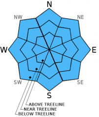
| Mid Slope Winds: | E | Variable | Variable |
| Wind Speed: | 10 to 15 mph | Light winds | Light winds |
| Expected snowfall: | 0 | 0 | 0 |
For 8000 ft. to 9000 ft.
| Saturday | Saturday Night | Sunday | |
|---|---|---|---|
| Weather: | Partly cloudy skies. | Partly cloudy skies, becoming clear. | Sunny skies. |
| Temperatures: | 16 to 23 deg. F. | 4 to 10 deg. F. | 20 to 27 deg. F. |
| Ridge Top Winds: | SE | Variable | SE |
| Wind Speed: | 15 to 20 mph with gusts to 30 mph. | Light winds | Light winds increasing to 10 to 15 mph in the afternoon. |
| Expected snowfall: | 0 | 0 | 0 |


