


For 7000 ft. to 8000 ft.
| Saturday | Saturday Night | Sunday | |
|---|---|---|---|
| Weather: | Sunny skies, becoming mostly cloudy. | Mostly cloudy skies. | Mostly cloudy skies. A slight chance of snow showers in the afternoon. |
| Temperatures: | 48 to 54 deg. F. | 23 to 30 deg. F. | 44 to 50 deg. F. |
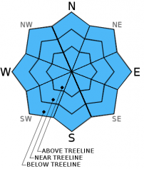
| Mid Slope Winds: | SW | SW | SW |
| Wind Speed: | 10 to 15 mph. Gusts up to 25 mph in the afternoon. | 15 to 20 mph with gusts to 30 mph in the evening, becoming light. | 15 to 20 mph with gusts to 30 mph, increasing to 25 to 30 mph with gusts to 45 mph in the afternoon. |
| Expected snowfall: | 0 | 0 | 0 to trace |
For 8000 ft. to 9000 ft.
| Saturday | Saturday Night | Sunday | |
|---|---|---|---|
| Weather: | Sunny skies, becoming mostly cloudy. | Mostly cloudy skies. | Mostly cloudy skies. A slight chance of snow showers in the afternoon. |
| Temperatures: | 42 to 48 deg. F. | 22 to 29 deg. F. | 40 to 46 deg. F. |
| Ridge Top Winds: | SW | SW | SW |
| Wind Speed: | 25 to 35 mph with gusts to 50 mph. | 25 to 30 mph with gusts to 45 mph, decreasing to 10 to 15 mph with gusts to 25 mph after midnight. | 25 to 30 mph with gusts to 50 mph, increasing to 35 to 40 mph with gusts to 60 mph in the afternoon. |
| Expected snowfall: | 0 | 0 | 0 to trace |


