THIS AVALANCHE FORECAST EXPIRED ON April 8, 2016 @ 7:01 am
Avalanche Forecast published on April 7, 2016 @ 7:01 am
Issued by Andy Anderson - Tahoe National Forest - Sierra Avalanche Center

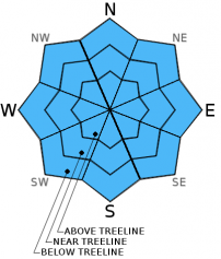
MODERATE danger will quickly form on slopes steeper than 35 degrees on all aspects and elevations starting in the mid morning hours with the E-SE-S-SW aspects that receive morning sun. This warming should continue onto the W-NW-N-NE aspects during the day. Loose wet avalanches large enough to threaten backcountry travelers will be possible again today. Evaluate snow and terrain carefully. Identify and avoid the areas where wet snow deep enough for loose wet avalanches exists. 

2. Moderate

?

Above Treeline
Heightened avalanche conditions on specific terrain features. Evaluate snow and terrain carefully; identify features of concern.

2. Moderate

?

Near Treeline
Heightened avalanche conditions on specific terrain features. Evaluate snow and terrain carefully; identify features of concern.

2. Moderate

?

Below Treeline
Heightened avalanche conditions on specific terrain features. Evaluate snow and terrain carefully; identify features of concern.
    Heightened avalanche conditions on specific terrain features. Evaluate snow and terrain carefully; identify features of concern.
Avalanche Problem 1: Loose Wet
  • Type ?
  • Aspect/Elevation ?
  • Likelihood ?
    Certain
    Very Likely
    Likely
    Possible
    Unlikely
  • Size ?
    Historic
    Very Large
    Large
    Small

Warmer overnight lows that remained well above freezing in most areas and some scattered thin cloud cover will mean that any refreeze that did occur as a result of radiational cooling last night will be weak and thin at best. Today's warm temperatures and plentiful morning sunshine will quickly melt through this weak refreeze. In addition to these warming influences, some afternoon cloud cover may help distribute the warmth to all aspects. Once the refreeze melts, the ice bonds that give the snowpack strength will have melted away leaving deep loose weak wet snow in many areas. Loose wet avalanches will become possible on slopes steeper than 35 degrees wherever loose wet snow exists. Loose wet activity will become possible on the E-SE-S-SW-W aspects at all elevations first and then progress to the NW-N-NE aspects as they warm up a little later. Most of the wet snow instabilities should manifest as loose wet avalanches but other forms of wet snow instabilities like glide cracks or wet slabs are not impossible. 

Once last night's melt-freeze crust starts to become unsupportable and the wet snow starts to deepen, it becomes unstable very quickly. In the last few days the snowpack has become unsupportable in many areas before noon. As soon as the snowpack starts becoming unsupportable, it is time to move to more frozen aspects, onto lower angle slopes away from anything steep, or to trade boots for flip-flops and head for an afternoon activity that does not involve snow.

Stepping off your equipment and sinking into wet snow above your boot tops and small surface instabilities like roller balls, pinwheels, or point releases can provide clues that enough wet snow has formed for larger loose wet avalanches to become an issue. Terrain traps like gullies, creeks, and cliffs can greatly increase the risk of any size loose wet avalanches.

recent observations

This week's observations have shown melt-freeze conditions on all aspects and elevations that start out frozen in the morning and quickly soften as the day warms up. The first slopes to soften in the mid morning hours are the E-SE-S aspects followed by the SW and W aspects. These slopes have held the most well developed melt-freeze crusts and corn snow conditions. The sun-exposed northerly aspects have soften slightly slower often waiting till late morning. On these northerly aspects transitional snow still exists below the melt freeze crusts. Several loose wet avalanches of various sizes have been reported this week as well as a few isolated larger wet snow instabilities like a wet slab and some glide cracks when the snow pack did not refreeze early in the week. 

Weather and CURRENT CONDITIONS
weather summary

Warm weather should prevail over the region again today with highs in the upper 50's above 7000 ft. Some cloud cover should begin to move into the area today and the winds should shift to the southwest and increase tonight ahead of a low pressure expected to arrive tomorrow afternoon. Some showers may start tomorrow afternoon but the bulk of the precipitation should hold off till Friday night. The forecast calls for high snow levels that start out above 9000 on Friday before they drop to 8000-8500 during the night on Friday night so much of the precipitation accompanying this storm should fall as rain. 

CONDITIONS ALONG THE SIERRA CREST BETWEEN 8200 FT. AND 9200 FT. IN THE LAST 24 HOURS
6am temperature: 37 to 45 deg. F.
Max. temperature: 53 to 58 deg. F.
Average ridgetop wind direction: East
Average ridgetop wind speed: 15 to 25 mph
Maximum ridgetop wind gust: 50 mph
New snowfall: 0 inches
Total snow depth: 68 to 110 inches
Two-Day Mountain Weather Forecast Produced in partnership with the Reno NWS
For 7000 ft. to 8000 ft.
Thursday Thursday Night Friday
Weather: Partly cloudy becoming mostly cloudy Mostly cloudy with a slight chance of rain showers after midnight Cloudy with a chance of rain showers in the morning and rain likely in the afternoon
Temperatures: 54 to 61 deg. F. 31 to 38 deg. F. 49 to 55 deg. F.
Mid Slope Winds: East Southwest Variable
Wind Speed: 10 to 15 mph 10 to 15 mph with gusts to 25 mph after midnight Light
Expected snowfall: 0 0 Rain: up to .3
For 8000 ft. to 9000 ft.
Thursday Thursday Night Friday
Weather: Partly cloudy becoming mostly cloudy Mostly cloudy with a slight chance of showers after midnight Cloudy with a chance of rain and snow showers in the morning and rain and snow likely in the afternoon. Snow levels around 9000 ft.
Temperatures: 50 to 57 deg. F. 31 to 38 deg. F. 41 to 48 deg. F.
Ridge Top Winds: East Southwest South shifting to southwest in the afternoon
Wind Speed: 15 to 25 mph with gusts to 40 mph 20 to 30 mph with gusts to 35 mph increasing to 45 mph after midnight 20 to 25 mph with gusts to 40 mph decreasing to 10 to 15 mph in the afternoon
Expected snowfall: 0 0 Mostly rain with upper elevation snow up to 3
Disclaimer

This avalanche advisory is provided through a partnership between the Tahoe National Forest and the Sierra Avalanche Center. This advisory covers the Central Sierra Nevada Mountains between Yuba Pass on the north and Ebbetts Pass on the south. Click here for a map of the forecast area. This advisory applies only to backcountry areas outside established ski area boundaries. This advisory describes general avalanche conditions and local variations always occur. This advisory expires 24 hours after the posted time unless otherwise noted. The information in this advisory is provided by the USDA Forest Service who is solely responsible for its content.

For a recorded version of the Avalanche Advisory call (530) 587-3558 x258