


For 7000 ft. to 8000 ft.
| Wednesday | Wednesday Night | Thursday | |
|---|---|---|---|
| Weather: | Partly cloudy. | Partly cloudy. | Partly cloudy. |
| Temperatures: | 47 to 54 deg. F. | 27 to 35 deg. F. | 47 to 54 deg. F. |
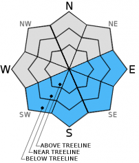
| Mid Slope Winds: | SW | W | SE |
| Wind Speed: | 10 to 15mph with gusts to 25mph. | 10 to 15mph shifting to the SE after midnight. | 10 to 15mph in the morning becoming light. |
| Expected snowfall: | 0 | 0 | 0 |
For 8000 ft. to 9000 ft.
| Wednesday | Wednesday Night | Thursday | |
|---|---|---|---|
| Weather: | Partly cloudy. | Partly cloudy. | Partly cloudy. |
| Temperatures: | 44 to 51 deg. F. | 25 to 32 deg. F. | 45 to 52 deg. F. |
| Ridge Top Winds: | SW | S | S |
| Wind Speed: | 15 to 25mph with gusts to 35mph. | 15 to 25mph with gusts to 35mph. | 15 to 20mph with gusts to 30mph. |
| Expected snowfall: | 0 | 0 | 0 |


