THIS AVALANCHE FORECAST EXPIRED ON February 12, 2016 @ 6:58 am
Avalanche Forecast published on February 11, 2016 @ 6:58 am
Issued by Andy Anderson - Tahoe National Forest - Sierra Avalanche Center

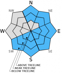
This morning the avalanche danger is LOW. As the day warms up, pockets of MODERATE danger will quickly form on E-SE-S-SW aspects due to the possibility of loose wet avalanches. Some small loose wet issues may form on near and below treeline N-NE aspects in isolated or extreme terrain. Small human triggered roller balls, pinwheels, and point-releases should comprise most of the loose wet activity, but some loose wet avalanches could involve enough snow to cause problems for backcountry travelers. 

2. Moderate

?

Above Treeline
Heightened avalanche conditions on specific terrain features. Evaluate snow and terrain carefully; identify features of concern.

2. Moderate

?

Near Treeline
Heightened avalanche conditions on specific terrain features. Evaluate snow and terrain carefully; identify features of concern.

2. Moderate

?

Below Treeline
Heightened avalanche conditions on specific terrain features. Evaluate snow and terrain carefully; identify features of concern.
    Heightened avalanche conditions on specific terrain features. Evaluate snow and terrain carefully; identify features of concern.
Avalanche Problem 1: Loose Wet
  • Type ?
  • Aspect/Elevation ?
  • Likelihood ?
    Certain
    Very Likely
    Likely
    Possible
    Unlikely
  • Size ?
    Historic
    Very Large
    Large
    Small

While some refreeze may have occurred last night due to heat radiating out into the night sky from the snowpack, the overnight temperatures well above freezing and the scattered cloud cover should mean that last night's refreeze was weak. Continued warm temperatures and some sunshine should quickly melt through last night's weak refreeze leaving a deep layer of wet snow on the surface even though the light to moderate winds and partly cloudy skies should keep slopes a little cooler today. The partly cloudy skies may also allow the wet snow to spread onto some of N and NE facing slopes as the clouds prevent radiational cooling and act as a blanket that can help distribute warmth to non-sun-exposed areas. Human triggered loose wet avalanches will become possible today on slopes 35 degrees and steeper where wet snow forms.

The majority of wet snow instabilities should form on sun-exposed E-SE-S-SW aspects, but some may also form on near and below treeline N-NE aspects. Small roller balls, pinwheels, and point release avalanches should comprise most of these loose wet instabilities, but some of them could entrain enough snow to cause problems for backcountry travelers. Stepping off your equipment and sinking into wet snow above your boots can indicate that enough wet snow exists on a slope for a loose wet avalanche problem. Small loose wet instabilities like roller balls and pinwheels often foreshadow larger loose wet snow issues as well. These clues or other signs of wet snow issues mean that it is time to find a more frozen slope or switch to a different afternoon activity.

recent observations

Yesterday observations from Negro Canyon and Castle Peak (Donner Summit area) showed firm melt freeze crusts and exposed rain crusts on the sun-exposed E-SE-S-SW aspects during the morning. By mid day some corn snow had formed above these crusts. Observations later in the day on Becker Peak (near Echo Summit) showed that the melt-freeze crusts on the SE-S-SW aspects became unsupportable by 1 pm, and shin deep wet snow existed on those aspects by that time. Loose wet avalanches also occurred around Emerald Bay yesterday with one of them running down an E aspect and depositing about 3 ft of debris onto the road. This slide occurred between 11 am and 3 pm. On the northerly aspects observers in Negro Canyon found some lingering patches of soft cold snow in sheltered areas. On Becker Peak the snow on the northerly aspects had started to become wet and sticky and allowed some small human triggered roller balls and pinwheels to occur by 2 pm. Snowpit data and general observations from both Negro Canyon and Becker Peak did not reveal any signs of instabilities buried in the snowpack. 

Weather and CURRENT CONDITIONS
weather summary

Warm weather and some overnight cloud cover kept temperatures well above freezing last night. Remote sensors between 8000 and 9000 ft. reported temperatures in the upper 30's to mid 40's at 6 am this morning. High pressure over the region will keep the weather warm and dry. The forecast calls for daytime highs in the upper 40's to mid 50's again today and tomorrow. Some cloud cover and light to moderate southwest winds should continue during the next 36 hours as some small low pressure systems move through the Pacific Northwest. 

CONDITIONS ALONG THE SIERRA CREST BETWEEN 8200 FT. AND 9200 FT. IN THE LAST 24 HOURS
6am temperature: 36 to 46 deg. F.
Max. temperature: 48 to 55 deg. F.
Average ridgetop wind direction: Southwest
Average ridgetop wind speed: 10 to 15 mph
Maximum ridgetop wind gust: 36 mph
New snowfall: 0 inches
Total snow depth: 64 to 82 inches
Two-Day Mountain Weather Forecast Produced in partnership with the Reno NWS
For 7000 ft. to 8000 ft.
Thursday Thursday Night Friday
Weather: Partly cloudy Partly cloudy Partly cloudy
Temperatures: 48 to 55 deg. F. 28 to 38 deg. F. 47 to 54 deg. F.
Mid Slope Winds: Southwest Southwest Southwest
Wind Speed: 15 to 20 mph with gusts to 30 mph in the afternoon 15 to 20 mph with gusts to 30 mph 15 to 20 mph with gusts to 30 mph
Expected snowfall: 0 0 0
For 8000 ft. to 9000 ft.
Thursday Thursday Night Friday
Weather: Partly cloudy Partly cloudy Partly cloudy
Temperatures: 45 to 52 deg. F. 30 to 36 deg. F. 42 to 49 deg. F.
Ridge Top Winds: Southwest Southwest Southwest
Wind Speed: 15 to 25 mph with gusts to 35 mph 20 to 30 mph with gusts to 45 mph 15 to 25 mph with gusts to 35 mph
Expected snowfall: 0 0 0
Disclaimer

This avalanche advisory is provided through a partnership between the Tahoe National Forest and the Sierra Avalanche Center. This advisory covers the Central Sierra Nevada Mountains between Yuba Pass on the north and Ebbetts Pass on the south. Click here for a map of the forecast area. This advisory applies only to backcountry areas outside established ski area boundaries. This advisory describes general avalanche conditions and local variations always occur. This advisory expires 24 hours after the posted time unless otherwise noted. The information in this advisory is provided by the USDA Forest Service who is solely responsible for its content.