THIS AVALANCHE FORECAST EXPIRED ON February 21, 2016 @ 6:53 am
Avalanche Forecast published on February 20, 2016 @ 6:53 am
Issued by Andy Anderson - Tahoe National Forest - Sierra Avalanche Center

MODERATE avalanche danger still exists on wind loaded near and above treeline NW-N-NE-E-SE aspects steeper than 35 degrees due to lingering wind slabs. Depending on the amount of daytime warming that occurs today, enough wet snow may form on the E-SE-S-SW-W aspects steeper than 35 degrees for the avalanche danger to rise to MODERATE on those slopes as well due to loose wet snow instabilities. Human triggered avalanches remain possible today.

2. Moderate

?

Above Treeline
Heightened avalanche conditions on specific terrain features. Evaluate snow and terrain carefully; identify features of concern.

2. Moderate

?

Near Treeline
Heightened avalanche conditions on specific terrain features. Evaluate snow and terrain carefully; identify features of concern.

2. Moderate

?

Below Treeline
Heightened avalanche conditions on specific terrain features. Evaluate snow and terrain carefully; identify features of concern.
    Heightened avalanche conditions on specific terrain features. Evaluate snow and terrain carefully; identify features of concern.
Avalanche Problem 1: Wind Slab
  • Type ?
  • Aspect/Elevation ?
  • Likelihood ?
    Certain
    Very Likely
    Likely
    Possible
    Unlikely
  • Size ?
    Historic
    Very Large
    Large
    Small

Two wind slab avalanches (one skier triggered and one triggered by an intentional cornice drop) that occurred yesterday as well as evidence of several other avalanches that occurred early Thursday morning during the storm were reported to the avalanche center yesterday. Wind loading and wind transport continued all day yesterday and last night and means that human triggered wind slab avalanches will remain possible today even though they may have grown more difficult to trigger. Due to the duration and strength of the winds a mix of firm, hard wind slabs that could break above the person that triggers them and softer wind slabs will exist on wind loaded slopes. Wind loaded N-NE-E aspects and cross loaded NW and SE aspects steeper than 35 degrees in near and above terrain represent the most likely places to find unstable wind slabs. Wind loaded couliors, unsupported slopes, convex rollovers, and slopes in complex or extreme terrain remain especially suspect. These wind slabs will most likely fail on weaknesses within the storm snow like density changes or graupel layers. The wind slab avalanches that remain possible today could still involve enough snow to have serious consequences.

Clues like recent wind slab avalanches on similar slopes, shooting cracks on lower angle wind loaded terrain, cornices above a slope, blowing snow, wind drifted snow, ripples in the snow surface, firm hollow sounding snow, and other wind created textures can help identify where wind slabs may exist. Use observations and clues like these to find where the wind slabs lurk and then avoid those wind slabs and their run out zones.

Avalanche Problem 2: Loose Wet
  • Type ?
  • Aspect/Elevation ?
  • Likelihood ?
    Certain
    Very Likely
    Likely
    Possible
    Unlikely
  • Size ?
    Historic
    Very Large
    Large
    Small

Today's warmer temperatures combined with periods of sun may provide enough warming for some loose wet snow instabilities to become possible as the recent snow starts to warm up. The forecasted cloud cover and light winds should limit the loose wet instabilities that do form and should prevent larger more widespread loose wet avalanches. Isolated, small loose wet point releases, roller balls, and pinwheels should comprise the majority of the loose wet instabilities that form today unless the forecasted cloud cover does not materialize and/or the temperatures climb higher than forecasted. More sun and higher daytime temperatures would mean larger and more widespread wet snow instabilities. 

recent observations

Yesterday wind slab avalanches occurred on Andesite Ridge (Donner Summit) and on a lower east facing slope on Slide Mountain (Mt. Rose area). On Andesite Ridge the crown depth measured 12 to 18 inches in depth and on Slide Mountain it measured 12 inches. A skier triggered the avalanche on Slide Mountain and an oven sized piece of cornice dropped onto the slope from above triggered the slide on Andesite Ridge. Wind transport and loading continued to occur at both of these locations yesterday. 

Other observations from Rose Knob Peak, Castle Peak, Luther Pass, and Stateline Ridge also showed continued wind loading in exposed areas. Snowpit tests on wind slabs on Castle Peak yielded unstable results that failed within the wind loaded snow. Tests on Rose Knob Peak and Stateline Ridge did not produce unstable results and indicated that the wind slabs have gained some strength. In more sheltered non wind affected areas near and below treeline, observations in all of these areas showed a more consolidated snowpack and signs of instability proved difficult to find.

Weather and CURRENT CONDITIONS
weather summary

The gale force southwest winds that have persisted since the start of Thursday's storm started to decrease after midnight last night. They still remain strong but should continue to decrease today as a high pressure ridge begins building over the region. The forecast calls for some cloud cover to develop over the area today and slightly warmer temperatures with daytime highs in the upper 30's to to low 40's above 7000 ft. and mid to upper 30's above 8000 ft. This cloud cover should move out of the region tonight, and tomorrow should bring sunny skies and warmer weather with highs in the mid to upper 40's above 7000 ft. and low 40's above 8000 ft.

CONDITIONS ALONG THE SIERRA CREST BETWEEN 8200 FT. AND 9200 FT. IN THE LAST 24 HOURS
6am temperature: 23 to 32 deg. F.
Max. temperature: 26 to 36 deg. F.
Average ridgetop wind direction: Southwest
Average ridgetop wind speed: 35 to 50 mph
Maximum ridgetop wind gust: 81 mph
New snowfall: up to 1 inches
Total snow depth: 66 to 95 inches
Two-Day Mountain Weather Forecast Produced in partnership with the Reno NWS
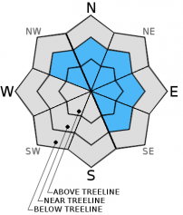
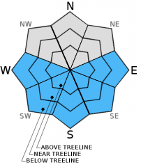
For 7000 ft. to 8000 ft.
Saturday Saturday Night Sunday
Weather: Sunny becoming partly cloudy Mostly cloudy becoming clear Sunny
Temperatures: 38 to 45 deg. F. 24 to 28 deg. F. 42 to 49 deg. F.
Mid Slope Winds: Southwest Southwest Southwest
Wind Speed: 10 to 20 mph with gusts to 30 mph in the morning becoming light in the afternoon 10 to 15 mph with gusts to 25 mph 10 to 20 mph with gusts to 30 mph
Expected snowfall: 0 0 0
For 8000 ft. to 9000 ft.
Saturday Saturday Night Sunday
Weather: Sunny becoming partly cloudy Mostly cloudy becoming clear Sunny
Temperatures: 32 to 38 deg. F. 28 to 32 deg. F. 37 to 42 deg. F.
Ridge Top Winds: Southwest Southwest West
Wind Speed: 30 to 45 mph with gusts to 60 mph decreasing to 10 to 15 mph with gusts to 25 mph in the afternoon 15 to 25 mph with gusts to 40 mph 15 to 25 mph with gusts to 40 mph
Expected snowfall: 0 0 0
Disclaimer

This avalanche advisory is provided through a partnership between the Tahoe National Forest and the Sierra Avalanche Center. This advisory covers the Central Sierra Nevada Mountains between Yuba Pass on the north and Ebbetts Pass on the south. Click here for a map of the forecast area. This advisory applies only to backcountry areas outside established ski area boundaries. This advisory describes general avalanche conditions and local variations always occur. This advisory expires 24 hours after the posted time unless otherwise noted. The information in this advisory is provided by the USDA Forest Service who is solely responsible for its content.