


For 7000 ft. to 8000 ft.
| Monday | Monday Night | Tuesday | |
|---|---|---|---|
| Weather: | Sunny skies. | Clear skies. | Sunny skies. |
| Temperatures: | 41 to 48 deg. F. | 25 to 30 deg. F. | 45 to 51 deg. F. |
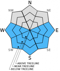
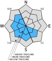
| Mid Slope Winds: | NW to N | N to E | E |
| Wind Speed: | 10 to 15 mph with gusts to 25 mph. | 10 to 20 mph with gusts to 30 mph. | 10 to 15 mph with gusts to 25 mph in the morning, becoming light. |
| Expected snowfall: | 0 | 0 | 0 |
For 8000 ft. to 9000 ft.
| Monday | Monday Night | Tuesday | |
|---|---|---|---|
| Weather: | Sunny skies. | Clear skies. | Sunny skies. |
| Temperatures: | 34 to 41 deg. F. | 30 to 33 deg. F. | 38 to 45 deg. F. |
| Ridge Top Winds: | N | N to NE | NE shifting to W |
| Wind Speed: | 15 to 25 mph with gusts to 40 mph. | 20 to 35 mph with gusts to 50 mph, increasing to 25 to 40 mph with gusts to 60 mph after midnight. | 20 to 30 mph with gusts to 50 mph, shifting and decreasing to 10 to 15 mph in the afternoon. |
| Expected snowfall: | 0 | 0 | 0 |


