THIS AVALANCHE FORECAST EXPIRED ON January 11, 2016 @ 6:59 am
Avalanche Forecast published on January 10, 2016 @ 6:59 am
Issued by Brandon Schwartz - Tahoe National Forest

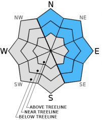
Unusual avalanche conditions exist with pockets of MODERATE avalanche danger in open areas at and below treeline on N-NE-E-SE aspects on slopes 35 degrees and steeper. This is due to persistent slabs associated with the Jan 5 buried surface hoar layer. For all other areas, LOW avalanche danger exists. Avoid steep terrain adjacent to areas of recent avalanche activity, even if the crown and debis are covered under a couple inches of new snow and now look old.

1. Low

?

Above Treeline
Generally safe avalanche conditions. Watch for unstable snow on isolated terrain features.

2. Moderate

?

Near Treeline
Heightened avalanche conditions on specific terrain features. Evaluate snow and terrain carefully; identify features of concern.

2. Moderate

?

Below Treeline
Heightened avalanche conditions on specific terrain features. Evaluate snow and terrain carefully; identify features of concern.
    Heightened avalanche conditions on specific terrain features. Evaluate snow and terrain carefully; identify features of concern.
Avalanche Problem 1: Persistent Slab
  • Type ?
  • Aspect/Elevation ?
  • Likelihood ?
    Certain
    Very Likely
    Likely
    Possible
    Unlikely
  • Size ?
    Historic
    Very Large
    Large
    Small

The Jan 5 surface hoar layer now buried 1 to 1.5 feet deep in the snowpack became very reactive on Tuesday and continued to contribute to skier/snowboarder triggered avalanches on Thursday and Friday on Andesite Ridge (Donner Summit area) and on Red Lake Peak (Carson Pass area). This is a very unusual avalanche problem for this region. Currently, the areas where avalanches are most likely to be triggered are not in the traditional wind loaded zones along the ridgelines, but in steep open areas at treeline and below treeline on N-NE-E aspects and possibly SE aspects. This layer has been very slow to stabilize with recent snowpit data pointing to ongoing problems. This weak layer is certainly not abiding by any mythical "24 hour rule".

Making travel decisions more difficult is the fact that this weak layer does not exist or is not reactive in all areas. Don't let a lack of evidence of instability in one portion of the forecast area affect how decisions are made when moving to another part of the forecast area. Continue to search out signs of instability including recent avalanche activity, even if it "looks old" buried under an inch or two of recent snowfall. Snowpit data is very helpful, but it has to come from the right locations, and it never proves stability. Have a conversation with your travel partner(s) and make sure everyone understands that this is an at treeline and below treeline problem. Shift the focus from the traditional wind loaded avalanche start zones up high to the steep wind protected open areas lower down on the mountain. If in doubt, stick to slopes less than 32 degrees in steepness.

Forecast discussion

Ridgetop winds did not materialize as forecast yesterday. This created little to no new wind slab formation over the past 24 hours in the vast majority of areas. Any isolated wind slabs that did form yesterday are expected to remain small. Isolated cracking is possible today in above treeline areas that actually received some wind loading. Actual natural or human triggered wind slab avalanches are unlikely today.

recent observations

Skier and snowboarder triggered avalanches were reported on Thursday on Andesite Ridge (Donner Summit area) and on Thursday and Friday on Red Lake Peak (Carson Pass area). In both cases avalanches occurred in steep open terrain near treeline to below treeline on NE to E aspects. Snowpack failure occurred 1 to 1.5 below the snow surface at the base of the recent storm snow accumulated since Jan 5. Snowpit data collected over the last two days in the Donner Summit area is indicating that where Jan 5 surface hoar crystals are 6 mm to 10 mm or larger they are remaining reactive and where they are 5 mm and smaller they are becoming less reactive. Several testpits dug yesterday in likely buried surface hoar terrain around Barker Peak and Barker Pass (Blackwood Canyon area) showed an absence of the Jan 5 buried surface hoar layer and no formal or informal signs of instability. No signs of the Jan 5 surface hoar layer have been reported this past week from the Mount Rose area.

Weather and CURRENT CONDITIONS
weather summary

High pressure will build over the region today and last through Tuesday. Some lingering clouds and snow showers are possible this morning, especially in areas along the east side of Lake Tahoe that experience enhanced moisture from lake effect. Most areas under snow showers are expected to receive a trace of new snow with up to a few inches possible in lake effect areas. Cloud cover is forecast to decrease as the day progresses. Maximum daytime air temperatures are expected to reach the mid 20s to low 30s today for areas above 7,000'. Ridgetop winds are forecast to remain light today through tomorrow morning. Air temperature inversion conditions will likely set up tonight. Increasing cloud cover and a chance for light snow showers returns tomorrow afternoon.

CONDITIONS ALONG THE SIERRA CREST BETWEEN 8200 FT. AND 9200 FT. IN THE LAST 24 HOURS
6am temperature: 21 to 25 deg. F.
Max. temperature: 29 to 31 deg. F.
Average ridgetop wind direction: SW
Average ridgetop wind speed: 10 mph
Maximum ridgetop wind gust: 35 mph
New snowfall: Trace to 2 inches
Total snow depth: 53 to 62 inches
Two-Day Mountain Weather Forecast Produced in partnership with the Reno NWS
For 7000 ft. to 8000 ft.
Sunday Sunday Night Monday
Weather: Mostly cloudy skies, becoming partly cloudy. Isolated snow showers in the morning. Partly cloudy skies. Mostly cloudy skies with a slight chance of snow showers in the afternoon.
Temperatures: 25 to 32 deg. F. 9 to 19 deg. F. 29 to 36 deg. F.
Mid Slope Winds: Variable Variable SW
Wind Speed: Light winds Light winds Light winds increasing to 10 to 15 mph with gusts to 25 mph in the afternoon.
Expected snowfall: 0 to trace 0 0 to trace
For 8000 ft. to 9000 ft.
Sunday Sunday Night Monday
Weather: Mostly cloudy skies, becoming partly cloudy. Isolated snow showers in the morning. Partly cloudy skies. Mostly cloudy skies with a slight chance of snow showers in the afternoon.
Temperatures: 23 to 30 deg. F. 13 to 19 deg. F. 26 to 33 deg. F.
Ridge Top Winds: SW Variable W
Wind Speed: 10 to 15 mph in the morning, becoming light. Light winds 10 to 15 mph increasing to 20 to 25 mph with gusts to 35 mph in the afternoon.
Expected snowfall: 0 to trace 0 0 to trace
Disclaimer

This avalanche advisory is provided through a partnership between the Tahoe National Forest and the Sierra Avalanche Center. This advisory covers the Central Sierra Nevada Mountains between Yuba Pass on the north and Ebbetts Pass on the south. Click here for a map of the forecast area. This advisory applies only to backcountry areas outside established ski area boundaries. This advisory describes general avalanche conditions and local variations always occur. This advisory expires 24 hours after the posted time unless otherwise noted. The information in this advisory is provided by the USDA Forest Service who is solely responsible for its content.