


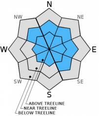


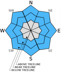
For 7000 ft. to 8000 ft.
| Monday | Monday Night | Tuesday | |
|---|---|---|---|
| Weather: | Cloudy skies, becoming mostly cloudy. Snow tapering by mid morning. | Cloudy skies with a slight chance of snow showers after midnight. | Cloudy skies with snow likely. |
| Temperatures: | 32 to 37 deg. F. | 22 to 27 deg. F. | 32 to 37 deg. F. |
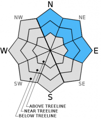
| Mid Slope Winds: | SW | SW | SW |
| Wind Speed: | 10 to 20 with gusts to 35 mph, decreasing to 10 to 15 mph with gusts to 25 mph in the afternoon. | 15 to 25 mph with gusts to 35 mph. | 25 to 35 mph with gusts to 50 mph, increasing to 35 to 45 mph with gusts to 70 mph in the afternoon. |
| Expected snowfall: | 3 to 5 | 0 to trace | 3 to 8 |
For 8000 ft. to 9000 ft.
| Monday | Monday Night | Tuesday | |
|---|---|---|---|
| Weather: | Cloudy skies, becoming mostly cloudy. Snow tapering by mid morning. | Cloudy skies with a slight chance of snow showers after midnight. | Cloudy skies with snow likely. |
| Temperatures: | 27 to 32 deg. F. | 20 to 26 deg. F. | 27 to 32 deg. F. |
| Ridge Top Winds: | W | SW | SW |
| Wind Speed: | 25 to 35 mph with gusts to 50 mph, decreasing to 20 to 25 mph with gusts to 40 mph in the afternoon. | 20 to 25 mph with gusts to 40 mph, increasing to 30 to 35 mph with gusts to 50 mph. | 50 to 55 mph with gusts to 85 mph, increasing to 65 to 70 mph with gusts to 105 mph in the afternoon. |
| Expected snowfall: | 3 to 5 | 0 to trace | 3 to 8 |


