


For 7000 ft. to 8000 ft.
| Wednesday | Wednesday Night | Thursday | |
|---|---|---|---|
| Weather: | Mostly cloudy then becoming partly cloudy. | Partly cloudy then becoming mostly cloudy. | Mostly cloudy. |
| Temperatures: | 36 to 42 deg. F. | 22 to 28 deg. F. | 37 to 43 deg. F. |
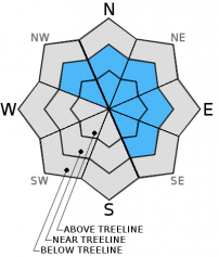
| Mid Slope Winds: | SW | SW | SW |
| Wind Speed: | 15 to 30mph with gusts to 40mph decreasing to 10 to 20mph with gusts to 30mph in the afternoon. | 10 to 20mph with gusts to 30mph in the evening then becoming light. | Light winds becoming 15 to 20mph with gusts to 30mph in the afternoon. |
| Expected snowfall: | 0 | 0 | 0 |
For 8000 ft. to 9000 ft.
| Wednesday | Wednesday Night | Thursday | |
|---|---|---|---|
| Weather: | Mostly cloudy then becoming partly cloudy. | Partly cloudy then becoming mostly cloudy. | Mostly cloudy. |
| Temperatures: | 31 to 36 deg. F. | 22 to 29 deg. F. | 34 to 40 deg. F. |
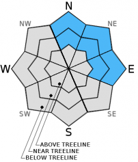
| Ridge Top Winds: | W | SW to SE | SE to SW |
| Wind Speed: | 35 to 40mph with gusts to 60mph decreasing to 25 to 30mph with gusts to 40mph in the afternoon. | Southwest 20 to 25mph with gusts to 40mph then becoming southeast 10 to 15mph after midnight. | Southeast 10 to 15mph increasing to southwest 35 to 40mph with gusts to 60mph in the afternoon. |
| Expected snowfall: | 0 | 0 | 0 |


