


For 7000 ft. to 8000 ft.
| Monday | Monday Night | Tuesday | |
|---|---|---|---|
| Weather: | Partly cloudy skies, becoming sunny. | Clear skies. | Sunny skies, becoming partly cloudy. |
| Temperatures: | 29 to 36 deg. F. | 18 to 26 deg. F. | 35 to 42 deg. F. |
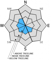
| Mid Slope Winds: | NE | SE | Variable |
| Wind Speed: | 15 to 20 mph with gusts to 30 mph. | 10 to 15 mph. | Light winds |
| Expected snowfall: | 0 | 0 | 0 |
For 8000 ft. to 9000 ft.
| Monday | Monday Night | Tuesday | |
|---|---|---|---|
| Weather: | Partly cloudy skies, becoming sunny. | Clear skies. | Sunny skies, becoming partly cloudy. |
| Temperatures: | 26 to 33 deg. F. | 16 to 23 deg. F. | 33 to 40 deg. F. |
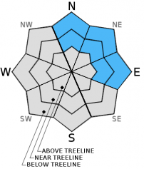
| Ridge Top Winds: | NE | E | E |
| Wind Speed: | 30 to 35 mph with gusts to 50 mph, decreasing to 20 to 25 mph with gusts to 40 mph in the afternoon. | 15 to 20 mph with gusts to 30 mph. | 10 to 15 mph in the morning, becoming light. |
| Expected snowfall: | 0 | 0 | 0 |


