THIS AVALANCHE FORECAST EXPIRED ON January 29, 2016 @ 7:00 am
Avalanche Forecast published on January 28, 2016 @ 7:00 am
Issued by Andy Anderson - Tahoe National Forest - Sierra Avalanche Center

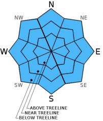
LOW avalanche danger exists on all elevations and aspects today. Some unstable snow could exist on isolated terrain features. As the next storm impacts the region tonight and tomorrow expect the avalanche danger to increase quickly.

1. Low

?

Above Treeline
Generally safe avalanche conditions. Watch for unstable snow on isolated terrain features.

1. Low

?

Near Treeline
Generally safe avalanche conditions. Watch for unstable snow on isolated terrain features.

1. Low

?

Below Treeline
Generally safe avalanche conditions. Watch for unstable snow on isolated terrain features.
    Generally safe avalanche conditions. Watch for unstable snow on isolated terrain features.
Avalanche Problem 1: Normal Caution
  • Type ?
  • Aspect/Elevation ?

Even though the winds will increase today, wind slab formation should remain limited due to the lack of snow available for transport on the sun crusted and wind scoured windward aspects. Other than some minor wind transport, today's warm temperatures, increased cloud cover, and possible light rain could allow some small loose wet instabilities like sluffs, roller balls, or pinwheels to form as well.  Both the loose wet snow and the isolated wind slabs should remain small.

Even though avalanche activity has become unlikely, backcountry travelers should still practice safe travel techniques like traveling one at a time in avalanche terrain, regrouping safe spots out of the avalanche paths, avoiding travel near terrain traps, and practicing good communication within your group. Small avalanches can still occur in isolated areas or extreme terrain during LOW avalanche danger

Forecast discussion

What happened to the deep persistent weak layer?

In early to mid January, up to 3 separate surface hoar layers formed and were buried by subsequent storms on N-NE-E aspects near treeline and below treeline.  These buried surface hoar layers are currently buried 1.5 to 4.5 feet deep in the snowpack.  A widespread persistent slab avalanche cycle occurred Jan 5 through Jan 19 on these weak layers.  Many slopes have been "cleaned out" by already avalanching, or the surface hoar has been collapsed or compressed and has gained strength.  Targeted observations and snowpack tests have shown that these layers, in the majority of locations, are no longer reactive and have assimilated into the snowpack.  No avalanche activity has been associated with these buried surface hoar layers since Jan. 19.

This deep persistent avalanche problem has become unlikely and has been removed as an avalanche problem.

recent observations

Observations from Donner Peak, Castle Peak, and Rubicon Peak found soft snow on northerly aspects yesterday. On Castle Peak observers reported some minor sluffing with no other signs of instability. Snowpit data and general observations from Donner Peak and Rubicon Peak also did not find any signs of instabilities. On Rubicon Peak snowpit work did identify the remains of a buried surface hoar layer, but this layer has rounded, become much stronger, and mostly assimilated into the snowpack. Tests targeting this layer also did not show any signs of lingering weakness.  

Weather and CURRENT CONDITIONS
weather summary

Warm dry weather will continue today due to the high pressure ridge over the region. This ridge should start to move eastward as a strong storm approaches the region. Cloud cover and southwest winds should begin to increase today and continue increasing as the storm moves into the area tonight and tomorrow. Some light rain may begin this afternoon especially north of I-80, and heavier precipitation should start to fall after midnight tonight and continue into Saturday. Snow levels will start high with the current forecast calling for 8000 to 9000 ft snow levels through tomorrow afternoon. The forecast calls for .5 to 1 inches of precipitation that falls as a mix of rain and snow depending on elevation by the end of the day tomorrow. Areas above snow line could see 3 to 7 inches of heavy wet snow with areas below that seeing mostly rain. The precipitation should start to change over to snow Friday afternoon and evening as cold front associated with this system moves into the area. Heavy snow should continue through Friday night and early Saturday morning. By Saturday morning snow levels should fall to below 5500 ft. For more information and the lasted weather forecasts check in with the Reno NWS.

CONDITIONS ALONG THE SIERRA CREST BETWEEN 8200 FT. AND 9200 FT. IN THE LAST 24 HOURS
6am temperature: 34 to 42 deg. F.
Max. temperature: 38 to 48 deg. F.
Average ridgetop wind direction: West to southwest
Average ridgetop wind speed: 15 to 20 mph
Maximum ridgetop wind gust: 30 mph
New snowfall: 0 inches
Total snow depth: 65 to 80 inches
Two-Day Mountain Weather Forecast Produced in partnership with the Reno NWS
For 7000 ft. to 8000 ft.
Thursday Thursday Night Friday
Weather: Partly cloudy with a slight chance of rain in the afternoon Cloudy with a chance of rain Rain
Temperatures: 39 to 46 deg. F. 32 to 37 deg. F. 37 to 42 deg. F.
Mid Slope Winds: Southwest Southwest Southwest
Wind Speed: 10 to 20 mph with gusts to 30 mph 15 to 25 mph with gusts to 40 mph 25 to 35 mph with gusts to 65 mph
Expected snowfall: 0 Rain: .06 - .1 Rain: .5-.75
For 8000 ft. to 9000 ft.
Thursday Thursday Night Friday
Weather: Partly cloudy with a slight chance of rain and snow in the afternoon Cloudy with a chance of rain and snow Rain and snow
Temperatures: 35 to 42 deg. F. 29 to 36 deg. F. 30 to 37 deg. F.
Ridge Top Winds: West to southwest West to southwest Southwest
Wind Speed: 25 to 30 mph with gusts to 45 mph increasing to 30 to 45 mph with gusts to 65 mph in the afternoon 40 to 45 mph with gusts to 70 mph increasing to 55 to 60 mph with gusts to 90 mph after midnight 50 to 75 mph with gusts between 90 and 110 mph
Expected snowfall: 0 Rain: .06 - .1 in. | Snow: 0 to 1 Rain: .5-.75 in. | Snow: 3 to 6
Disclaimer

This avalanche advisory is provided through a partnership between the Tahoe National Forest and the Sierra Avalanche Center. This advisory covers the Central Sierra Nevada Mountains between Yuba Pass on the north and Ebbetts Pass on the south. Click here for a map of the forecast area. This advisory applies only to backcountry areas outside established ski area boundaries. This advisory describes general avalanche conditions and local variations always occur. This advisory expires 24 hours after the posted time unless otherwise noted. The information in this advisory is provided by the USDA Forest Service who is solely responsible for its content.