THIS AVALANCHE FORECAST EXPIRED ON January 31, 2016 @ 7:00 am
Avalanche Forecast published on January 30, 2016 @ 7:00 am
Issued by Andy Anderson - Tahoe National Forest - Sierra Avalanche Center

CONSIDERABLE avalanche danger exists in near and above treeline terrain on NW-N-NE-E-SE aspects on slopes steeper than 35 degrees due to newly formed wind slabs. MODERATE avalanche danger exists elsewhere. The largest wind slabs will exist above 8700 ft. where more snow has accumulated. Human triggered wind slab avalanches are likely today, and some small sluffs may be possible. People traveling in the backcountry should make careful snowpack evaluations and use cautious route-finding and conservative decision-making.

3. Considerable

?

Above Treeline
Dangerous avalanche conditions. Careful snowpack evaluation, cautious route-finding and conservative decision-making essential.

3. Considerable

?

Near Treeline
Dangerous avalanche conditions. Careful snowpack evaluation, cautious route-finding and conservative decision-making essential.

2. Moderate

?

Below Treeline
Heightened avalanche conditions on specific terrain features. Evaluate snow and terrain carefully; identify features of concern.
    Dangerous avalanche conditions. Careful snowpack evaluation, cautious route-finding and conservative decision-making essential.
Avalanche Problem 1: Wind Slab
  • Type ?
  • Aspect/Elevation ?
  • Likelihood ?
    Certain
    Very Likely
    Likely
    Possible
    Unlikely
  • Size ?
    Historic
    Very Large
    Large
    Small

Above 8700 ft. fragile wind slabs large enough to bury people already exist and could already measure 2 to 4 ft in depth on wind loaded near and above treeline slopes. Wind slabs will become more widespread as more snow accumulates at all elevations today. The upper elevation wind slabs will grow in size and extent, and the smaller wind slabs that existed below 8700 ft. will become large enough to bury people. Human triggered wind slab avalanches are likely today and some natural wind slabs may still be possible. Wind loaded N-NE-E and cross loaded NW and SE aspects on open near and above treeline slopes represent the best places to find fragile wind slabs, but they could also exist in some below treeline areas or in some traditionally sheltered areas due to the strength of the winds. Use clues like blowing snow, cornices above a slope, wind drifted snow, ripples in the snow, and other wind created textures to help identify where wind slabs have formed.  

Avalanche Problem 2: Loose Dry
  • Type ?
  • Aspect/Elevation ?
  • Likelihood ?
    Certain
    Very Likely
    Likely
    Possible
    Unlikely
  • Size ?
    Historic
    Very Large
    Large
    Small

Some small loose dry instabilities may occur within the storm snow in non wind affected areas today. These should remain small and limited to point release slides or sluffs. If they do happen, they should not entrain much snow. Sheltered slopes steeper than 35 degrees with cold new snow on the surface represent the best places to trigger these small sluffs. Loose wet instabilities have become unlikely but not impossible since the rain has stopped and the temperatures have dropped, but a deep layer of wet snow will still exist below the surface today. 

recent observations

Yesterday 6 to 12 inches of rain soaked snow existed on the snow surface as of 11 am. As the rain continued this layer of wet snow kept getting deeper. Skiers could easily trigger large loose wet snow instabilities like pinwheels and roller balls that grew up to 6-7 ft in diameter as they rolled down the hill and loose wet point release sluffs that entrained all of the wet snow. The rain also cause some cornices to collapse and triggered some natural loose wet instabilities. Ski kicks on one steep test slope did result in some small shooting cracks that traveled up to 18 inches away from their origin.

Weather and CURRENT CONDITIONS
weather summary

So far this storm has dropped ~ 2 to 4 inches of water onto the mountains north of Emerald Bay and 1.5 to 2 inches south of Emerald Bay. Since snow levels hovered between 8700 and 9700 ft for much of yesterday, most of this precipitation fell as rain below 9000 ft. Snow level started dropping yesterday afternoon and finally fell below 7500 to 7000 ft. around 1 am this morning. Above 8700 ft. areas north of Emerald Bay have received 10 to 14 inches of new snow on top of a very wet snowpack while areas south of Emerald Bay have gotten more like 4 to 7 inches. Below 8700 ft. only 3 to 5 inches of snow has accumulated since 1 am. Snow levels have now fallen to below 5000 ft, and snow should continue through tonight with another 4 to 6 inches of accumulation today and 1 to 3 inches tonight across the region. The strong southwest winds should also continue to buffet the area before decreasing this afternoon and overnight. So far they have averaged 40 to 50 mph with gusts in the 90's and one sensor even recorded a gust of 120 mph. The forecast calls for unsettled cold and snowy weather again tomorrow as this system continues to move eastward. The mountains could see another 2 to 4 inches of new snow tomorrow.

CONDITIONS ALONG THE SIERRA CREST BETWEEN 8200 FT. AND 9200 FT. IN THE LAST 24 HOURS
6am temperature: 25 to 32 deg. F.
Max. temperature: 37 to 39 deg. F.
Average ridgetop wind direction: Southwest
Average ridgetop wind speed: 45 to 55 mph
Maximum ridgetop wind gust: 120 mph
New snowfall: Below 8700 ft: 3 to 5 inches | Above 8700 ft: 10 to 14 inches
Total snow depth: 66 to 90 inches
Two-Day Mountain Weather Forecast Produced in partnership with the Reno NWS
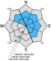
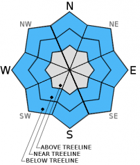
For 7000 ft. to 8000 ft.
Saturday Saturday Night Sunday
Weather: Cloudy with snow Cloudy with snow Cloudy with snow likely in the morning and snow showers in the afternoon
Temperatures: 24 to 31 deg. F. 11 to 18 deg. F. 18 to 25 deg. F.
Mid Slope Winds: Southwest Southwest Southwest
Wind Speed: 40 to 45 mph with gusts to 65 mph decreasing to 25 to 30 mph with gusts to 45 mph in the afternoon 15 to 20 mph with gusts to up to 35 mph decreasing to 10 to 15 mph with gusts to 25 mph after midnight 15 to 20 mph with gusts to 30 mph decreasing to 5 to 15 mph with gusts to 20 mph in the afternoon
Expected snowfall: 4 to 6 1 to 3 2 to 4
For 8000 ft. to 9000 ft.
Saturday Saturday Night Sunday
Weather: Cloudy with snow Cloudy with snow Cloudy with snow likely in the morning and snow showers in the afternoon
Temperatures: 21 to 28 deg. F. 9 to 16 deg. F. 13 to 29 deg. F.
Ridge Top Winds: Southwest West shifting to southwest Southwest
Wind Speed: 65 to 70 mph with gusts to 100 mph decreasing to 40 to 45 mph with gusts to 70 mph 30 to 35 mph with gusts to 50 mph decreasing to 15 to 20 mph with gusts to 30 mph after midnight 25 to 30 mph with gusts to 45 mph decreasing to 10 to 15 mph with gusts to 25 mph in the afternoon
Expected snowfall: 4 to 6 1 to 3 2 to 4
Disclaimer

This avalanche advisory is provided through a partnership between the Tahoe National Forest and the Sierra Avalanche Center. This advisory covers the Central Sierra Nevada Mountains between Yuba Pass on the north and Ebbetts Pass on the south. Click here for a map of the forecast area. This advisory applies only to backcountry areas outside established ski area boundaries. This advisory describes general avalanche conditions and local variations always occur. This advisory expires 24 hours after the posted time unless otherwise noted. The information in this advisory is provided by the USDA Forest Service who is solely responsible for its content.