THIS AVALANCHE FORECAST EXPIRED ON January 6, 2016 @ 6:54 am
Avalanche Forecast published on January 5, 2016 @ 6:54 am
Issued by Steve Reynaud - Tahoe National Forest

Avalanche danger will rise to considerable today on slopes 32 degrees and steeper on all aspects and elevations due to wind slabs and storm slabs.  Natural avalanches are possible and human triggered avalanches will be likely today.  Areas of greatest danger will be along the Sierra Crest and South of Hwy. 50.  For other areas avalanche danger will range from Moderate to Considerable.  Dangerous avalanche conditions exist, cautious route finding and conservative decision making will be essential today. 

3. Considerable

?

Above Treeline
Dangerous avalanche conditions. Careful snowpack evaluation, cautious route-finding and conservative decision-making essential.

3. Considerable

?

Near Treeline
Dangerous avalanche conditions. Careful snowpack evaluation, cautious route-finding and conservative decision-making essential.

3. Considerable

?

Below Treeline
Dangerous avalanche conditions. Careful snowpack evaluation, cautious route-finding and conservative decision-making essential.
    Dangerous avalanche conditions. Careful snowpack evaluation, cautious route-finding and conservative decision-making essential.
Avalanche Problem 1: Wind Slab
  • Type ?
  • Aspect/Elevation ?
  • Likelihood ?
    Certain
    Very Likely
    Likely
    Possible
    Unlikely
  • Size ?
    Historic
    Very Large
    Large
    Small

As the current storm impacts our forecast area, wind slabs will develop on NW-N-NE-E aspects above treeline, near treeline and even below treeline.  Winds are forecasted to be from the South at 40 to 50mph above 8000' with gusts up to 90mph.   Wind slabs will become larger and more dangerous throughout the day with human and natural avalanche activity expected.  These wind slabs will likely become large enough to bury a backcountry user.

Make a plan for avoiding wind loaded terrain today.  Look for blowing snow, cornice formation, wind pillows, and snow surface clues to help identify where wind slabs are located.

Avalanche Problem 2: Storm Slab
  • Type ?
  • Aspect/Elevation ?
  • Likelihood ?
    Certain
    Very Likely
    Likely
    Possible
    Unlikely
  • Size ?
    Historic
    Very Large
    Large
    Small

Storm slabs could develop today in near treeline terrain and below treeline terrain on all aspects.  The weather forecast calls for potentially 8 to 15'' of new snow today with chances for the most snow along the Sierra Crest and South of Hwy. 50.  These storm slabs could have weaknesses at the old snow/new snow interface or within the current new storm snow.  Snowfall rates along the Sierra Crest could exceed 2''/hour today, easily over stressing the strength of the new storm snow.

Avoid steeper slopes and terrain traps near and below treeline.  Use small, inconsequential test slopes to gather information.  Hand pits can be effective to see how the new storm snow is bonding to the old snow surface and for identifying weak layers within the new storm snow.


recent observations

Observations from Trimmer Peak (Luther Pass), Jakes Peak (West Shore), and Lincoln Ridge (Yuba Pass) all showed a consolidating snowpack with few issues moving forward.  Another day of cloudy and warmer conditions led to sticky snow conditions on all aspects below 7500' with some roller ball and small D1 wet loose avalanches in the afternoon hours.  The isolated, small, wind slab instabilities of the previous couple days were not reported to be an issue yesterday.

Weather and CURRENT CONDITIONS
weather summary

A winter weather advisory is in effect to 4pm this afternoon.  2'' of new snow has fallen along the Sierra Crest overnight.  Today, 8 to 15'' of new snow is expected along the Sierra Crest with 4 to 8'' of new snow expected East of Lake Tahoe.  This storm is coming from the South so there will be more snow accumulation south of Hwy. 50 then in the northern portion of the forecast area.  Winds will shift from the South to the Southwest during the day bringing better chances of snow into the Tahoe Basin.

CONDITIONS ALONG THE SIERRA CREST BETWEEN 8200 FT. AND 9200 FT. IN THE LAST 24 HOURS
6am temperature: 24 to 26 deg. F.
Max. temperature: 28 deg. F.
Average ridgetop wind direction: South
Average ridgetop wind speed: 30 to 40 mph
Maximum ridgetop wind gust: 65 mph
New snowfall: 1 to 2 inches
Total snow depth: 46 to 55 inches
Two-Day Mountain Weather Forecast Produced in partnership with the Reno NWS
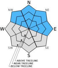
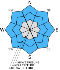
For 7000 ft. to 8000 ft.
Tuesday Tuesday Night Wednesday
Weather: Cloudy. Snow Cloudy. Snow likely in the evening, then chance of snow after midnight. Cloudy. Chance of snow in the morning then snow likely in the afternoon.
Temperatures: 25 to 32 deg. F. 15 to 21 deg. F. 20 to 27 deg. F.
Mid Slope Winds: South Southwest South
Wind Speed: 20 to 30mph with gusts to 45mph. 15 to 20mph with gusts to 30mph. 20 to 30mph with gusts to 40mph.
Expected snowfall: 5 to 11 Up to 2 2 to 7
For 8000 ft. to 9000 ft.
Tuesday Tuesday Night Wednesday
Weather: Cloudy. Snow. Cloudy. Snow likely in the evening then chance of snow after midnight. Cloudy. Chance of snow in the morning then snow likely in the afternoon.
Temperatures: 22 to 29 deg. F. 10 to 17 deg. F. 17 to 24 deg. F.
Ridge Top Winds: South Southwest South
Wind Speed: 40 to 50mph with gusts to 90mph. 20 to 30mph with gusts to 45mph. 35 to 40mph with gusts to 60mph increasing to 45 to 50mph with gusts to 75mph in the afternoon.
Expected snowfall: 6 to 12 Up to 2 3 to 9
Disclaimer

This avalanche advisory is provided through a partnership between the Tahoe National Forest and the Sierra Avalanche Center. This advisory covers the Central Sierra Nevada Mountains between Yuba Pass on the north and Ebbetts Pass on the south. Click here for a map of the forecast area. This advisory applies only to backcountry areas outside established ski area boundaries. This advisory describes general avalanche conditions and local variations always occur. This advisory expires 24 hours after the posted time unless otherwise noted. The information in this advisory is provided by the USDA Forest Service who is solely responsible for its content.