


For 7000 ft. to 8000 ft.
| Monday | Monday Night | Tuesday | |
|---|---|---|---|
| Weather: | Cloudy skies with rain and snow in the morning. Snow in the afternoon. | Cloudy skies with snow. | Mostly cloudy skies with scattered snow showers. |
| Temperatures: | 36 to 42 deg. F. | 18 to 25 deg. F. | 25 to 32 deg. F. |
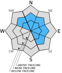
| Mid Slope Winds: | SW | SW | W |
| Wind Speed: | 25 to 40 mph with gusts to 50 mph. | 30 to 40 mph with gusts to 60 mph. | 25 to 30 mph with gusts to 40 mph, decreasing to 15 to 20 mph with gusts to 30 mph in the afternoon. |
| Expected snowfall: | Up to 2 | 3 to 5 | Up to 1 |
For 8000 ft. to 9000 ft.
| Monday | Monday Night | Tuesday | |
|---|---|---|---|
| Weather: | Cloudy skies with a chance of snow in the morning. Snow in the afternoon. | Cloudy skies with snow. | Mostly cloudy skies with scattered snow showers. |
| Temperatures: | 32 to 38 deg. F. | 15 to 22 deg. F. | 25 to 31 deg. F. |
| Ridge Top Winds: | SW | SW | W |
| Wind Speed: | 50 to 70 mph with gusts to 90 mph. Gusts to 105 mph in the afternoon. | 45 to 65 mph with gusts to 95 mph. Gusts decreasing to 80 mph after midnight. | 40 to 45 mph with gusts to 65 mph, decreasing to 25 to 30 mph with gusts to 45 mph in the afternoon. |
| Expected snowfall: | up to 2 | 4 to 8 | Up to 1 |


