THIS AVALANCHE FORECAST EXPIRED ON March 23, 2016 @ 6:50 am
Avalanche Forecast published on March 22, 2016 @ 6:50 am
Issued by Steve Reynaud - Tahoe National Forest

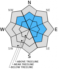
Considerable avalanche danger exists on NW-N-NE-E-SE aspects near and above treeline on slopes steeper than 35 degrees due to newly formed wind slabsModerate avalanche danger exists on all other aspects and elevations.  New snow, gale force winds and continuing winds throughout the day will make wind slabs grow larger and be sensitive to triggering.  Natural avalanches are possible with human triggered avalanches likely today.

3. Considerable

?

Above Treeline
Dangerous avalanche conditions. Careful snowpack evaluation, cautious route-finding and conservative decision-making essential.

3. Considerable

?

Near Treeline
Dangerous avalanche conditions. Careful snowpack evaluation, cautious route-finding and conservative decision-making essential.

2. Moderate

?

Below Treeline
Heightened avalanche conditions on specific terrain features. Evaluate snow and terrain carefully; identify features of concern.
    Dangerous avalanche conditions. Careful snowpack evaluation, cautious route-finding and conservative decision-making essential.
Avalanche Problem 1: Wind Slab
  • Type ?
  • Aspect/Elevation ?
  • Likelihood ?
    Certain
    Very Likely
    Likely
    Possible
    Unlikely
  • Size ?
    Historic
    Very Large
    Large
    Small

6-10'' of new snow with gale force winds overnight have created wind slabs on NW-N-NE-E-SE aspects near and above treeline.  With new snow available for wind transport these wind slabs will continue to grow with strong to gale force SW winds that will switch to the W and then to the NW into the afternoon hours.  These wind slabs have the potential to be over 2' deep in the most wind prone locations and will remain sensitive to triggering throughout the day.  Natural avalanches remain possible and human triggered avalanches are likely.

Identify and avoid steep wind loaded terrain where wind slabs exists.  Look for signs of recent avalanche activity, blowing snow, wind pillows, cornices, and human triggered snow surface cracking. Avoid slopes steeper than 35 degrees where signs of wind slabs are present.  

recent observations

Observations yesterday from Tamarack Peak (Mt. Rose area) showed 2-4'' of new snow with strong winds.  This new snow was being transported throughout the day and creating small wind slabs on leeward slopes.  With the limited new snow, wind transport amounts were small and most windward slopes were scoured down to old snow surface crusts by mid day.  Snowpack tests and informal observations showed that these wind slabs were bonding well and were not reactive throughout the day.

Weather and CURRENT CONDITIONS
weather summary

We received 6 to 10'' of new snow overnight throughout the forecast area with strong to gale force SW winds.  The main precipitation event ended around 3am although isolated snow showers are possible throughout the day with up to 1'' of additional accumulation.  Winds are forecasted to remain strong to gale force in speed and move from the SW to the W and eventually to the NW during the afternoon.  This low pressure system exists the area tonight with dryer conditions and a warming trend throughout the week.

CONDITIONS ALONG THE SIERRA CREST BETWEEN 8200 FT. AND 9200 FT. IN THE LAST 24 HOURS
6am temperature: 14 to 22 deg. F.
Max. temperature: 28 to 35 deg. F.
Average ridgetop wind direction: SW
Average ridgetop wind speed: 40 to 50 mph
Maximum ridgetop wind gust: 82 mph
New snowfall: 6 to 10 inches
Total snow depth: 86 to 126 inches
Two-Day Mountain Weather Forecast Produced in partnership with the Reno NWS
For 7000 ft. to 8000 ft.
Tuesday Tuesday Night Wednesday
Weather: Mostly cloudy. Scattered snow showers. Mostly cloudy. Isolated snow showers in the evening. Partly cloudy.
Temperatures: 25 to 32 deg. F. 21 to 27 deg. F. 35 to 42 deg. F.
Mid Slope Winds: W W E
Wind Speed: 15 to 25mph. Gusts up to 40mph decreasing to 30mph in the afternoon. 15 to 20mph shifting to the NE after midnight. Gusts up to 30mph. 15 to 20mph with gusts to 30mph.
Expected snowfall: Up to 1 0 0
For 8000 ft. to 9000 ft.
Tuesday Tuesday Night Wednesday
Weather: Mostly cloudy. Scattered snow showers. Mostly cloudy. Isolated snow showers in the evening. Partly cloudy.
Temperatures: 25 to 31 deg. F. 15 to 22 deg. F. 32 to 39 deg. F.
Ridge Top Winds: W NW E
Wind Speed: 35 to 40mph with gusts to 60mph becoming NW 25 to 30mph with gusts to 45mph. 25 to 30mph shifting to the NE after midnight. Gusts up to 50mph. 15 to 25mph with gusts to 40mph.
Expected snowfall: Up to 1 0 0
Disclaimer

This avalanche advisory is provided through a partnership between the Tahoe National Forest and the Sierra Avalanche Center. This advisory covers the Central Sierra Nevada Mountains between Yuba Pass on the north and Ebbetts Pass on the south. Click here for a map of the forecast area. This advisory applies only to backcountry areas outside established ski area boundaries. This advisory describes general avalanche conditions and local variations always occur. This advisory expires 24 hours after the posted time unless otherwise noted. The information in this advisory is provided by the USDA Forest Service who is solely responsible for its content.

For a recorded version of the Avalanche Advisory call (530) 587-3558 x258