THIS AVALANCHE FORECAST EXPIRED ON March 29, 2016 @ 6:58 am
Avalanche Forecast published on March 28, 2016 @ 6:58 am
Issued by Brandon Schwartz - Tahoe National Forest

Snowfall amounts and avalanche danger will vary greatly around the forecast area today. Adjust terrain choices and route selection according to localized conditions. Near and above treeline on NW-N-NE-E-SE-S aspects on slopes 35 degrees and steeper, avalanche danger could range from LOW danger to CONSIDERABLE danger based on the size of newly formed wind slabs. Below treeline, avalanche danger could range from LOW danger to MODERATE danger on all aspects on slopes 35 degrees and steeper based on snowfall.

2. Moderate

?

Above Treeline
Heightened avalanche conditions on specific terrain features. Evaluate snow and terrain carefully; identify features of concern.

2. Moderate

?

Near Treeline
Heightened avalanche conditions on specific terrain features. Evaluate snow and terrain carefully; identify features of concern.

1. Low

?

Below Treeline
Generally safe avalanche conditions. Watch for unstable snow on isolated terrain features.
    Heightened avalanche conditions on specific terrain features. Evaluate snow and terrain carefully; identify features of concern.
Avalanche Problem 1: Wind Slab
  • Type ?
  • Aspect/Elevation ?
  • Likelihood ?
    Certain
    Very Likely
    Likely
    Possible
    Unlikely
  • Size ?
    Historic
    Very Large
    Large
    Small

In some locations around the forecast area, new wind slabs will build this morning in near treeline and above treeline terrain on NW-N-NE-E-SE-S aspects. The presence or absence and size of wind slabs will vary greatly today as new snowfall amounts vary widely across the forecast area. In the areas of greatest snowfall, wind slabs 1 to 2+ feet deep are possible today. This is certainly large enough to bury or injure a person. In these localized areas of higher snowfall, human triggered avalanches are possible to likely today and natural avalanches are possible. This avalanche problem may not exist in areas of minimal snowfall today.

Be aware of highly localized avalanche conditions today and avoid potentially unstable wind slabs where they have formed. Use clues such as blowing snow, recent avalanche activity, cornice formations, wind pillows, and human triggered snow surface cracking to help identify areas to avoid.


Avalanche Problem 2: Storm Slab
  • Type ?
  • Aspect/Elevation ?
  • Likelihood ?
    Certain
    Very Likely
    Likely
    Possible
    Unlikely
  • Size ?
    Historic
    Very Large
    Large
    Small

In localized areas where new snow amounts exceed 6 inches today, storm slabs could form in wind protected areas on all aspects below treeline on slope 35 degrees and steeper. Evaluate localized conditions for new snow amounts and the potential for unstable storm slabs. Clues such as human triggered snow surface cracking, test slope failures, and unstable snowpit test results in wind protected areas below treeline are helpful in identifying potentially unstable storm slabs. This avalanche problem may not exist in areas of minimal snowfall today.

recent observations

Observations made below 8,000' yesterday on Lincoln Ridge (Yuba Pass area) and near Blackwall on Donner Pass revealed widespread unstable wet snow conditions on all aspects. Loose wet avalanches were easily skier triggered on slopes 40 degrees and steeper. A few small to medium size loose wet avalanches were noted to have occurred naturally. Snow surface refreeze from the night before varied from poor to decent and was melted by mid to late morning in most areas. With the below freezing air temperatures last night and today, snow surface refreeze is expected to have occurred with new snow deposited on top of crust at all elevations on solar aspects and as well as on northerly aspects below 8,000' to 8,500'.

Weather and CURRENT CONDITIONS
weather summary

An "Inside Slider" type weather system is moving from NW to SE through Nevada this morning. A narrow band of snowfall has set up near I-80 and is depositing snow over the NE portion of the forecast area. Accumulated snowfall amounts will vary widely over the forecast are today with some locations picking up just a trace to 2 inches while other locations could see accumulations as much as 12 inches. A cold front associated with this weather system will decrease maximum daytime air temperatures by about 15 degrees over yesterday. This will keep maximum daytime air temperatures today in the 20s for areas above 7,000'. Ridgetop winds remain out of the SW this morning and are strong in speed. Wind direction is expected to shift to the W to NW as the day progresses. Wind speed will decrease tomorrow with continued cloud cover and snow showers.

CONDITIONS ALONG THE SIERRA CREST BETWEEN 8200 FT. AND 9200 FT. IN THE LAST 24 HOURS
6am temperature: 25 to 29 deg. F.
Max. temperature: 39 to 46 deg. F.
Average ridgetop wind direction: SW
Average ridgetop wind speed: 37 mph
Maximum ridgetop wind gust: 61 mph
New snowfall: 0 to 4 inches
Total snow depth: 74 to 114 inches
Two-Day Mountain Weather Forecast Produced in partnership with the Reno NWS
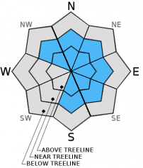
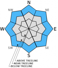
For 7000 ft. to 8000 ft.
Monday Monday Night Tuesday
Weather: Cloudy skies with snow showers in the morning. Scattered snow showers in the afternoon. Mostly cloudy skies with scattered snow showers in the evening. Isolated snow showers after midnight. Mostly cloudy skies with a chance of snow showers.
Temperatures: 25 to 30 deg. F. 15 to 20 deg. F. 29 to 34 deg. F.
Mid Slope Winds: NW N N
Wind Speed: 15 to 25 mph with gusts to 35 mph. 15 to 25 mph with gusts to 35 mph 15 to 20 mph. Gusts up to 30 mph in the morning.
Expected snowfall: Localized higher, but generally 1 to 4 Up to 1 0 to trace
For 8000 ft. to 9000 ft.
Monday Monday Night Tuesday
Weather: Cloudy skies with snow showers. Mostly cloudy skies with scattered snow showers in the evening. Isolated snow showers after midnight. Mostly cloudy skies with a chance of snow showers.
Temperatures: 23 to 29 deg. F. 9 to 16 deg. F. 25 to 30 deg. F.
Ridge Top Winds: W to NW N N
Wind Speed: 35 to 40 mph with gusts to 60 mph, decreasing to 20 to 25 mph with gusts to 35 mph in the afternoon. 20 to 30 mph with gusts to 50 mph. 15 to 25 mph with gusts to 35 mph.
Expected snowfall: Localized higher, but generally 2 to 5 Up to 1 0 to trace
Disclaimer

This avalanche advisory is provided through a partnership between the Tahoe National Forest and the Sierra Avalanche Center. This advisory covers the Central Sierra Nevada Mountains between Yuba Pass on the north and Ebbetts Pass on the south. Click here for a map of the forecast area. This advisory applies only to backcountry areas outside established ski area boundaries. This advisory describes general avalanche conditions and local variations always occur. This advisory expires 24 hours after the posted time unless otherwise noted. The information in this advisory is provided by the USDA Forest Service who is solely responsible for its content.

For a recorded version of the Avalanche Advisory call (530) 587-3558 x258