THIS AVALANCHE FORECAST EXPIRED ON March 5, 2016 @ 7:01 am
Avalanche Forecast published on March 4, 2016 @ 7:01 am
Issued by Andy Anderson - Tahoe National Forest - Sierra Avalanche Center

Increased cloud cover and winds combined with cooler daytime highs should keep the avalanche danger LOW for all elevations and aspects today. Some small loose wet snow instabilities may still form on isolated terrain features on slopes that receive rain today. Use normal caution in the backcountry. 

As a series of storms starts impacting the forecast area this afternoon and evening, the avalanche danger will increase quickly and avalanche problems like wind slabs and storm slabs will begin to form. 

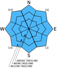
1. Low

?

Above Treeline
Generally safe avalanche conditions. Watch for unstable snow on isolated terrain features.

1. Low

?

Near Treeline
Generally safe avalanche conditions. Watch for unstable snow on isolated terrain features.

1. Low

?

Below Treeline
Generally safe avalanche conditions. Watch for unstable snow on isolated terrain features.
    Generally safe avalanche conditions. Watch for unstable snow on isolated terrain features.
Avalanche Problem 1: Normal Caution
  • Type ?
  • Aspect/Elevation ?

Avalanche activity should remain unlikely today. The cloudy skies, increased winds, slightly cooler temperatures, and the fact that the snowpack has been through a prolonged melt-freeze cycle should limit the formation of wet snow instabilities today, and the predicted snow and rain amounts should not be enough to form new avalanche problems. Some small isolated loose wet snow instabilities like roller balls, pinwheels, and the occasional point release may still form on isolated terrain features below 8500 ft. especially on slopes that receive rain. 

Once the snow starts accumulating the avalanche danger will increase, and avalanche problems like wind slabs and storm storm slabs will become increasingly likely and widespread. Wind slabs will begin forming tonight and could easily become a problem by tomorrow if the high end of forecasted snow amounts occurs. 

recent observations

Observations yesterday on Red Lake Peak (Carson Pass area) found stable, strong, well bonded snow on all aspects and did not reveal any signs of instability. The southerly aspects held melt-freeze conditions with 1-2 inches of soft corn snow resting above a solid and supportable melt-freeze crust above 8400 ft. The northerly aspects above 8400 ft. held a mix of firm, dry, cold snow and wind packed surfaces. This data agrees with most of the other data gathered this week around the forecast area and indicates that the current snowpack should handle new loading well. 

Weather and CURRENT CONDITIONS
weather summary

The forecast calls for increasing southwest winds and cloud cover today as the first in a series of storms approaches the region. Some light precipitation could arrive north of I-80 this morning. The precipitation should become more widespread this afternoon as the storm arrives over the region. Expect precipitation to continue through the night. Due to the warmer air associated with this first storm, snow levels should hover around 8000 to 8500 ft. today and through most of the night. After a short break in the weather tomorrow morning the southwest winds should increase to gale force speeds as second stronger winter storm moves into the area on Saturday afternoon. Precipitation should start tomorrow with snow levels between 7500 and 8500 ft. before they begin to fall with the arrival of a cold front tomorrow night. Snow fall amounts today, tonight and tomorrow could reach up to 10 inches above 8000 ft. by tomorrow afternoon if the stars align, but they will likely remain lower in the 4 to 8 inch range. The most intense part of the storm should arrive during the night on Saturday and continue into Sunday morning. The bulk of the snow and intense wind and high snowfall rates will occur during this timeframe. Check in with the Reno NWS for all the latest details on these impending storms.

CONDITIONS ALONG THE SIERRA CREST BETWEEN 8200 FT. AND 9200 FT. IN THE LAST 24 HOURS
6am temperature: 33 to 37 deg. F.
Max. temperature: 40 to 47 deg. F.
Average ridgetop wind direction: Southwest
Average ridgetop wind speed: 25 to 35 mph
Maximum ridgetop wind gust: 68 mph
New snowfall: 0 inches
Total snow depth: 53 to 81 inches
Two-Day Mountain Weather Forecast Produced in partnership with the Reno NWS
For 7000 ft. to 8000 ft.
Friday Friday Night Saturday
Weather: Mostly cloudy with a 30% chance of scattered rain showers. Snow levels around 8000 ft. Cloudy with a 50% chance of rain through the night and a chance of rain and snow after midnight. Snow levels between 7500 and 8500 ft. Cloudy with rain and snow likely. Snow level between 7500 and 8500 ft.
Temperatures: 42 to 49 deg. F. 27 to 34 deg. F. 40 to 47 deg. F.
Mid Slope Winds: Southwest Southwest Southwest
Wind Speed: 20 to 30 mph with gusts to 45 mph 25 to 35 mph with gusts to 45 mph increasing to 55 mph after midnight 40 to 50 mph with gusts to 65 mph increasing to 75 mph in the afternoon
Expected snowfall: Rain: up to .1 in. | Snow: up to 1 up to 2 up to 3
For 8000 ft. to 9000 ft.
Friday Friday Night Saturday
Weather: Mostly cloudy with a 30% chance of isolated snow showers in the morning then scattered snow showers in the afternoon. Snow levels around 8000 ft. Cloudy with a 50% chance of rain through the night and a chance of snow after midnight. Snow levels between 7500 and 8500 ft. Cloudy with snow likely. Snow level between 7500 and 8500 ft.
Temperatures: 38 to 45 deg. F. 26 to 33 deg. F. 36 to 43 deg. F.
Ridge Top Winds: Southwest Southwest Southwest
Wind Speed: 25 to 35 mph with gusts to 55 mph 30 to 35 mph with gusts to 55 mph increasing to 50 to 55 mph with gusts to 80 mph after midnight 55 to 60 mph with gusts to 95 mph increasing to 70 to 75 mph with gusts to 110 mph in the afternoon
Expected snowfall: up to 1 up to 4 up to 5
Disclaimer

This avalanche advisory is provided through a partnership between the Tahoe National Forest and the Sierra Avalanche Center. This advisory covers the Central Sierra Nevada Mountains between Yuba Pass on the north and Ebbetts Pass on the south. Click here for a map of the forecast area. This advisory applies only to backcountry areas outside established ski area boundaries. This advisory describes general avalanche conditions and local variations always occur. This advisory expires 24 hours after the posted time unless otherwise noted. The information in this advisory is provided by the USDA Forest Service who is solely responsible for its content.