


For 7000 ft. to 8000 ft.
| Monday | Monday Night | Tuesday | |
|---|---|---|---|
| Weather: | Cloudy skies with snow in the morning. Snow showers in the afternoon. | Mostly cloudy skies becoming partly cloudy. A chance of snow showers in the evening. A slight chance of snow showers after midnight. | Partly cloudy skies. A slight chance of snow showers in the morning. |
| Temperatures: | 25 to 32 deg. F. | 12 to 19 deg. F. | 32 to 39 deg. F. |
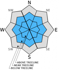
| Mid Slope Winds: | SW shifting to NW | N | S |
| Wind Speed: | 35 to 40 mph with gusts to 55 mph, shifting and decreasing to 10 to 15 mph in the afternoon. | 10 to 15 mph with gusts to 25 mph. | Light winds increasing to 10 to 15 mph with gusts to 25 mph in the afternoon. |
| Expected snowfall: | 3 to 6 | Up to 1 | 0 to trace |
For 8000 ft. to 9000 ft.
| Monday | Monday Night | Tuesday | |
|---|---|---|---|
| Weather: | Cloudy skies with snow in the morning. Snow showers in the afternoon. | Mostly cloudy skies becoming partly cloudy. A chance of snow showers in the evening. A slight chance of snow showers after midnight. | Partly cloudy skies. A slight chance of snow showers in the morning. |
| Temperatures: | 20 to 27 deg. F. | 10 to 17 deg. F. | 29 to 36 deg. F. |
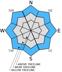
| Ridge Top Winds: | SW shifting to NW | N | NE shifting to SW |
| Wind Speed: | 55 to 60 mph with gusts to 85 mph, shifting and decreasing to 15 to 20 mph with gusts to 35 mph in the afternoon. | 20 to 30 mph with gusts to 45 mph. | 10 to 15 mph shifting and increasing to 20 to 25 mph with gusts to 35 mph in the afternoon. |
| Expected snowfall: | 3 to 6 | Up to 1 | 0 to trace |


