THIS AVALANCHE FORECAST EXPIRED ON November 29, 2016 @ 7:00 am
Avalanche Forecast published on November 28, 2016 @ 7:00 am
Issued by Andy Anderson - Tahoe National Forest - Sierra Avalanche Center

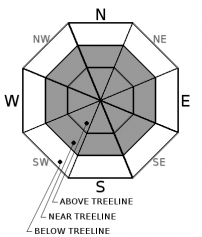
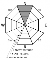
MODERATE avalanche danger exists on N aspects steeper than 30 degrees above 8300 ft. along the Sierra Crest and above 9300 ft. in the Mt. Rose area due to a persistent slab problem. MODERATE danger also exists on wind loaded near and above treeline slopes steeper than 35 degrees due to wind slab problems. Wind slabs may exist on any aspect due to the changing winds today. 

2. Moderate

?

Above Treeline
Heightened avalanche conditions on specific terrain features. Evaluate snow and terrain carefully; identify features of concern.

2. Moderate

?

Near Treeline
Heightened avalanche conditions on specific terrain features. Evaluate snow and terrain carefully; identify features of concern.

2. Moderate

?

Below Treeline
Heightened avalanche conditions on specific terrain features. Evaluate snow and terrain carefully; identify features of concern.
    Heightened avalanche conditions on specific terrain features. Evaluate snow and terrain carefully; identify features of concern.
Avalanche Problem 1: Wind Slab
  • Type ?
  • Aspect/Elevation ?
  • Likelihood ?
    Certain
    Very Likely
    Likely
    Possible
    Unlikely
  • Size ?
    Historic
    Very Large
    Large
    Small

Human triggered wind slab avalanches will remain possible today on steep wind-loaded slopes in near and above treeline terrain. The wind slabs that formed during the storm will still exist on the N-NE-E aspects as well as on some of the cross-loaded NW and SE aspects. Avalanches involving these wind slabs could entrain enough snow to bury a person. In addition to these wind slabs, new wind slabs may start to form on the E-SE-S aspects with cross loading on the NE and SW aspects as the winds shift to the northwest this afternoon. While these new wind slabs should remain smaller and not extend very far from ridgelines, they will also remain more sensitive and fragile.

Clues like blowing snow, cornices, drifted snow, and wind pillows can all help identify where wind slabs exist. Cracking around skis or snowmobiles in wind loaded terrain not only indicates that wind slabs exist, but also that a person's weight could break them loose. Avoiding areas where wind slabs exist represents a wise choice. Remember that even small avalanches can have serious consequences in these early season conditions.

Avalanche Problem 2: Persistent Slab
  • Type ?
  • Aspect/Elevation ?
  • Likelihood ?
    Certain
    Very Likely
    Likely
    Possible
    Unlikely
  • Size ?
    Historic
    Very Large
    Large
    Small

Persistent slab avalanches may be more difficult to trigger, but if one does release it would have dire consequences. Snowpit data continues to show a persistent weak layer buried 2 to 3 ft deep below the surface on N facing terrain above 8300 ft. in the northern part of the Sierra Crest (especially on Castle Peak) and above 9300 ft. in the Mt. Rose area. Tests targeting these persistent weak layers show that if these layers break the resulting fracture could travel long distances through those weak layers. Larger triggers like multiple people on the same slope, large cornice failures, or other avalanches could cause these layers to break. Smaller triggers that find the right trigger point could also initiate fractures in these layers. Shallowly buried rocks, areas near cliffs, or areas where the snowpack is more shallow represent some potential trigger points. This problem could exist on slopes 30 degrees and steeper. Persistent slabs can be remotely triggered.

While this problem is not widespread, its location matches the places that have the best coverage. Think twice about charging into these areas. Most informal observations do not give reliable information, and existing tracks do not indicate stability when dealing with persistent slabs.  Digging in the snow may be required to see if this problem exists in your area on your specific slope.  Avoiding North aspects above 30 degrees is another strategy to deal with this persistent weak layer


Forecast discussion

The most usable snowpack within the forecast area exists along the northern portion of the Sierra Crest where more snow exists. Along the Sierra Crest south of Tahoe City, snowpack depths decrease, even at the highest elevations. Recent storms have added to the snowpack in all areas but many rocks and shallowly buried obstacles still exist. The Mount Rose area in the NE portion of the forecast area has decent snowcover, but impact with rocks remains likely at the lower elevations in this area as well.

Due to the wide variances in snowcover between the northern and southern portions of the forecast area, this advisory is heavily biased towards the northern areas where the snowpack is more usable for over snow travel.

The avalanche center is still working on a limited number of observations so please submit observations through the "submit observations" buttons found throughout this website.

recent observations

Yesterday, observations revealed natural wind slab avalanches with crowns 1 to 3 ft. deep that had occurred in the early morning hours in the Grouse Rocks area, on the Castle Peak, and on Andesite Ridge. These wind slabs failed on steep NE-E aspects near upper elevation ridges. They all entrained enough snow to bury a person and ran over exposed rocks. In addition to these avalanches, some cracking and whumfing also occurred in response to a person's added weight on small wind loaded test slopes in the Castle Peak area during the day yesterday. Snowpit test targeting the wind slab/old snow interface at the upper elevations on Castle showed a mix of results with most tests yielding unstable results at this interface. In the Grouse Rocks area below the ridgelines, observers reported signs of good bonding between the old and new snow. 

Deeper in the snowpack weak layers of soft sugary snow still exist on N aspects at upper elevations. On Castle Peak at 8500 ft. and on Relay Ridge at 10,000 ft. snowpit data showed that the 11/16 facet layer still exists. Snowpit tests targeting this layer indicated that it may have been more difficult to trigger, but if it breaks fractures could still travel along that persistent weak layer.

Weather and CURRENT CONDITIONS
weather summary

After a period of decreased winds yesterday afternoon, the W and SW winds increased again last night. These strong winds should continue this morning before shifting to the NW this afternoon and decreasing. Some snow showers may occur today, but any accumulation should remain limited with only up to 1 inch of new snow forecasted. Tonight the winds should shift to the N and increase again as a small high-pressure ridge moves towards the region. These N and E winds should continue into tomorrow. Temperatures should remain cold with daytime highs in the upper 20's above 7000 ft. and overnight lows in the upper teens.

CONDITIONS ALONG THE SIERRA CREST BETWEEN 8200 FT. AND 9200 FT. IN THE LAST 24 HOURS
6am temperature: 23 to 28 deg. F.
Max. temperature: 24 to 30 deg. F.
Average ridgetop wind direction: West and southwest
Average ridgetop wind speed: Before midnight: 20-30 mph | After midnight: 50 mph mph
Maximum ridgetop wind gust: 90 mph
New snowfall: trace to 1 inches
Total snow depth: 13 to 26 inches
Two-Day Mountain Weather Forecast Produced in partnership with the Reno NWS
For 7000 ft. to 8000 ft.
Monday Monday Night Tuesday
Weather: Mostly cloudy with a chance of snow Mostly cloudy becoming partly cloudy Partly cloudy becoming sunny
Temperatures: 28 to 33 deg. F. 16 to 21 deg. F. 28 to 33 deg. F.
Mid Slope Winds: West shifting to northwest in the afternoon North East
Wind Speed: 20 to 30 mph with gusts to 55 mph decreasing to 10 to 15 mph with gusts to 30 mph in the afternoon 10 to 15 mph with gusts to 35 mph 10 to 20 mph with gusts to 35 mph
Expected snowfall: up to 1 0 0
For 8000 ft. to 9000 ft.
Monday Monday Night Tuesday
Weather: Mostly cloudy with a chance of snow Mostly cloudy becoming partly cloudy Partly cloudy becoming sunny
Temperatures: 24 to 29 deg. F. 16 to 21 deg. F. 29 to 34 deg. F.
Ridge Top Winds: West shifting to northwest in the afternoon Northeast Northeast
Wind Speed: 35 to 55 mph with gusts to 100 mph decreasing to 15 to 25 mph with gusts to 55 mph in the afternoon 20 to 40 mph with gusts to 55 mph increasing to 75 mph after midnight 20 to 40 mph with gusts to 95 mph decreasing to 70 mph in the afternoon
Expected snowfall: up to 1 0 0
Disclaimer

This avalanche advisory is provided through a partnership between the Tahoe National Forest and the Sierra Avalanche Center. This advisory covers the Central Sierra Nevada Mountains between Yuba Pass on the north and Ebbetts Pass on the south. Click here for a map of the forecast area. This advisory applies only to backcountry areas outside established ski area boundaries. This advisory describes general avalanche conditions and local variations always occur. This advisory expires 24 hours after the posted time unless otherwise noted. The information in this advisory is provided by the USDA Forest Service who is solely responsible for its content.

For a recorded version of the Avalanche Advisory call (530) 587-3558 x258