


For 7000 ft. to 8000 ft.
| Wednesday | Wednesday Night | Thursday | |
|---|---|---|---|
| Weather: | Partly cloudy skies, becoming mostly cloudy. Slight chance of snow showers in the afternoon. | Mostly cloudy skies. Slight chance of snow showers in the evening. Chance of snow showers after midnight. | Partly cloudy skies, becoming mostly cloudy. Chance of snow showers in the morning. A slight chance of snow showers in the afternoon. |
| Temperatures: | 32 to 37 deg. F. | 15 to 20 deg. F. | 25 to 30 deg. F. |
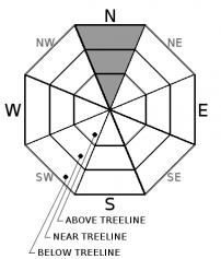
| Mid Slope Winds: | W | NW | NE |
| Wind Speed: | Light winds, increasing to 10 to 15 mph with gusts to 25 mph in the afternoon. | Light winds | Light winds, increasing to 10 to 15 mph with gusts to 30 mph in the afternoon. |
| Expected snowfall: | 0 to trace | Up to 1 | Up to 1 |
For 8000 ft. to 9000 ft.
| Wednesday | Wednesday Night | Thursday | |
|---|---|---|---|
| Weather: | Partly cloudy skies, becoming mostly cloudy. Slight chance of snow showers in the afternoon. | Mostly cloudy skies. Slight chance of snow showers in the evening. Chance of snow showers after midnight. | Partly cloudy skies, becoming mostly cloudy. Chance of snow showers in the morning. A slight chance of snow showers in the afternoon. |
| Temperatures: | 28 to 32 deg. F. | 14 to 19 deg. F. | 20 to 25 deg. F. |
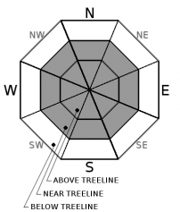
| Ridge Top Winds: | W | NW | NE |
| Wind Speed: | 15 to 20 mph with gusts to 40 mph. | 10 to 15 mph with gusts to 40 mph. | 10 to 20 mph with gusts to 35 mph, increasing to 15 to 25 mph with gusts to 45 mph in the afternoon. |
| Expected snowfall: | 0 to trace | Up to 1 | Up to 1 |


