

The last avalanche forecast for the 2023-2024 season will post on April 21st. Thank you to all who contributed to the avalanche center this season through observations, volunteer time, and/or financial contributions.
In partnership with: 
The last avalanche forecast for the 2023-2024 season will post on April 21st. Thank you to all who contributed to the avalanche center this season through observations, volunteer time, and/or financial contributions.
|
February 23, 2012 at 8:00 am |
|
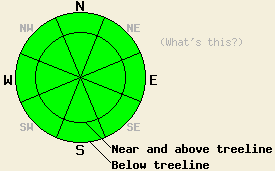
The avalanche danger remains LOW for all elevations and aspects. LOW danger does not mean no danger. Continue to use normal caution when traveling in the backcountry. |
|
|
|
North and east winds should bring some cooler air into the region today taht should limit daytime highs to the mid to upper 30's. The surface pressure gradient causing these winds should decrease tonight. By tomorrow the winds should shift back to the south and west. As the northerly winds cease bringing cool air into the region, temperatures should climb once again. Tomorrow's daytime highs should reach into the upper 40's and low 50's. The high pressure ridge over CA should keep skies clear through Friday.
Yesterday a wide variety of snow surface conditions existed on Tamarack Peak (photos, more info). A breakable crust has formed on the northerly aspects up to at least 9200 ft. On some slopes this crust exists at higher elevations. On the more exposed N-NE-E facing slopes, firm wind scoured surfaces prevailed. On a few of the shaded and sheltered NW-N-NE slopes above 9200 ft, softer conditions remained. Even in these areas the surface snow remained slightly more dense than the snow below it creating a "punchy" feel. People also reported breakable crusts on Rubicon and Maggie's yesterday. In the Tamarack Peak area on the more sun-exposed southerly aspects, melt-freeze conditions predominated. The warm temperatures and sunshine did manage to cause enough melting for a few inches of wet snow to form on these aspects by the afternoon. Below the surface the crust/facet combination still exists at the base of the recent snow on the NW-N-NE aspects on Tamarack Peak. Hand pits and slopes cuts on test slopes showed no signs of instability associated with this layer in this area yesterday. Extended column tests also indicated that fractures in this layer are harder to initiate, and they are also unlikely to travel though this layer. These observations match well with data collected across the forecast area over the last few days.
Today's Avalanche Concerns: Persistent Slabs
Observations over the last several days have indicated that the persistent weak layer made up of faceted snow and crusts at the base of the recent new snow has gone dormant. As this layer has adjusted to the weight of the recent snow above it, triggering avalanches has become more unlikely on near or below treeline NW-N-NE aspects. Unlikely does not mean impossible, and persistent weak layers like this one warrant extra caution. This weak layer has not gone away. It could re-awaken when more snow arrives. Continue to use caution and exercise good travel habits in order to minimize risk.
Few if any wet snow instabilities should form today due to daytime highs forecasted in the mid to upper 30's and north through easterly winds keeping the snow surface cool. Some roller balls or pinwheels may form near exposed rocks and trees on steep sun-exposed SE-S-SW facing slopes. If temperatures climb higher than forecasted today, wet snow instabilities may become more widespread and larger.
The avalanche danger remains LOW for all elevations and aspects. LOW danger does not mean no danger. Continue to use normal caution when traveling in the backcountry.
| 0600 temperature: | 28-33 deg. F. |
| Max. temperature in the last 24 hours: | 46-52 deg. F. |
| Average wind direction during the last 24 hours: | Southwest to northeast |
| Average wind speed during the last 24 hours: | 10-20 mph |
| Maximum wind gust in the last 24 hours: | Along the Sierra Crest: 34 mph | In the Mt Rose area: 49 mph |
| New snowfall in the last 24 hours: | O inches |
| Total snow depth: | 23-33 inches |
For 7000-8000 ft: |
|||
| Thursday: | Thursday Night: | Friday: | |
| Weather: | Sunny | Clear | Sunny |
| Temperatures: | 35-42 deg. F. | 19-26 deg. F. | 43-50 deg. F. |
| Wind direction: | Northeast | East | Southeast shifting to southwest in the afternoon |
| Wind speed: | 10-15 mph with gusts to 25 mph | 10-15 mph | 10-15 mph with gusts to 25 mph increasing to 20-25 mph with gusts to 40 mph in the afternoon |
| Expected snowfall: | O in. | O in. | O in. |
For 8000-9000 ft: |
|||
| Thursday: | Thursday Night: | Friday: | |
| Weather: | Sunny | Clear | Sunny |
| Temperatures: | 31-38 deg. F. | 21-28 deg. F. | 44-50 deg. F. |
| Wind direction: | Northeast | East | Southwest |
| Wind speed: | 20-30 mph with gusts to 50 mph decreasing to 40 mph in the afternoon | 20-25 mph with gusts to 35 mph decreasing to 10-15 mph with gusts to 25 mph after midnight | 20-30 mph with gusts to 35 mph increasing to 30-35 mph with gusts to 55 mph in the afternoon |
| Expected snowfall: | O in. | O in. | O in. |


This website is owned and maintained by the non-profit arm of the Sierra Avalanche Center. Some of the content is updated by the USDA avalanche forecasters including the forecasts and some observational data. The USDA is not responsible for any advertising, fund-raising events/information, or sponsorship information, or other content not related to the forecasts and the data pertaining to the forecasts.