

The last avalanche forecast for the 2023-2024 season will post on April 21st. Thank you to all who contributed to the avalanche center this season through observations, volunteer time, and/or financial contributions.
In partnership with: 
The last avalanche forecast for the 2023-2024 season will post on April 21st. Thank you to all who contributed to the avalanche center this season through observations, volunteer time, and/or financial contributions.
|
March 6, 2012 at 8:00 am |
|
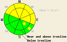
MODERATE avalanche danger exists on NW-N-NE-E aspects on slopes 35 degrees and steeper both above and below treeline due to ongoing deep slab instability and new wind loading. Pockets of MODERATE danger may also form on wind-loaded SE aspects 35 degrees and steeper today. Large destructive human triggered avalanches remain possible today. |
|
|
|
The southwest winds increased yesterday due to a strong cold front approaching the region. Snow showers started early this morning dropping one to three inches of snow across the area. Snow should continue through today with an additional three to seven inches of accumulation expected above 7000 ft and two to four inches at Lake level. The most intense period of snowfall should occur this morning with snowfall rates at up to two inches per hour. By this afternoon snow and clouds should start to decrease and the winds should shift to the north and northeast as the front departs. Temperatures should fall today and stay cold through tomorrow. Expect today's highs to occur this morning. By tonight lows could dip to near zero in the mountains. A high pressure ridge should start to build over the region bringing clear skies and strong north and east winds to the forecast area tonight and tomorrow. The forecast calls for average wind speeds of 50-60 mph with gusts above 95 mph along the ridgetops.
The persistent weak layer comprised of old crusts and weak sugary snow (facets) still exists near the base of the snow that fell at the end of February and the beginning of March. Observations across the forecast area have show that this problematic layer has become more variable as it tries to adjust to the weight of the slab on top it. As of yesterday it could support the slab in some areas but not in others. Due to the way that these kind of layers stabilize areas of stability and areas of instability could exist within a few feet of each other on the same slope. Yesterday, snowpit data and observations from Forestdale Divide near the recent snowmobile triggered avalanche showed that even though this layer remains well defined, the recent avalanche and subsequent explosive control work had made fractures less likely to travel through this layer on those slopes. Around the forecast area other recent data from uncontrolled slopes that have not avalanched have shown that propagation along this layer remains possible in some areas.
Today's Primary Avalanche Concern: Persistent Deep Slabs
Just as the persistent weak layer started to adjust to the weight above it, more snow and wind in the mountains will add more weight to the snowpack today. This additional weight could make triggering avalanches on this layer possible in more areas again today. Observations have shown that this layer exists on NW-N-NE aspects in both above and below treeline terrain. Digging into the snowpack will reveal whether or not this layer exists. The difference between the snow in this layer and the snow above it remains very easy to see and feel. Large human triggered deep slab avalanches remain possible today both above and below treeline on NW-N-NE aspects. Areas near exposed rock outcrops and other similar trigger points are locations where triggering a deep slab avalanche is more likely. Caution and conservative decision making remain prudent due to the variability of this layer and the consequences of its failure.
Today's Secondary Avalanche Concerns: Wind Slabs
Today's strong winds and additional snow will create new wind slabs on top of the snowpack. These slabs will not only add weight to the snowpack that could reactivate the persistent weak layer mentioned above, but they also present an avalanche concern themselves due to their rapid formation. Human triggered avalanches resulting from the failure of these wind slabs will become possible today as these slabs grow larger and more widespread. Avalanches that result from these wind slabs could also cause the persistent weak layer mentioned above to fail creating larger, deeper, and farther running avalanches. The largest and most fragile wind slabs will exist near and above treeline on heavily wind-loaded N-NE-E aspects and on cross-loaded NW and SE aspects. As the winds shift to the north and northeast this afternoon, they should begin to strip snow away from these newly formed wind slabs and deposit it back onto the previously scoured W-SW-S aspects. The wind slabs that form on these aspects should remain smaller and less problematic today. By tomorrow they could grow larger and more widespread.
MODERATE avalanche danger exists on NW-N-NE-E aspects on slopes 35 degrees and steeper both above and below treeline due to ongoing deep slab instability and new wind loading. Pockets of MODERATE danger may also form on wind-loaded SE aspects 35 degrees and steeper today. Large destructive human triggered avalanches remain possible today.
| 0600 temperature: | 19-26 deg. F. |
| Max. temperature in the last 24 hours: | 39-49 deg. F. |
| Average wind direction during the last 24 hours: | West southwest |
| Average wind speed during the last 24 hours: | 50 mph |
| Maximum wind gust in the last 24 hours: | 92 mph |
| New snowfall in the last 24 hours: | 1-3 inches |
| Total snow depth: | 27-51 inches |
For 7000-8000 ft: |
|||
| Tuesday: | Tuesday Night: | Wednesday: | |
| Weather: | Cloudy in the morning with snow. Clouds and snow decreasing in the afternoon. Temperatures dropping during the day. | Partly cloudy | Sunny |
| Temperatures: | 24-30 deg. F. | 0-7 deg. F. | 22-29 deg. F. |
| Wind direction: | West shifting to the north in the afternoon | Northeast | Northeast |
| Wind speed: | 20-30 mph with gusts to 50 mph decreasing to gusts to 40 mph in the afternoon | 35-45 mph with gusts to 70 mph | 35-40 mph with gusts to 60 mph decreasing to 25-30 mph with gusts to 50 mph in the afternoon |
| Expected snowfall: | 3-5 in. | O in. | O in. |
For 8000-9000 ft: |
|||
| Tuesday: | Tuesday Night: | Wednesday: | |
| Weather: | Cloudy in the morning with snow. Clouds and snow decreasing in the afternoon. Temperatures dropping during the day. | Partly cloudy | Sunny |
| Temperatures: | 20-26 deg. F. | 0-6 deg. F. | 23-28 deg. F. |
| Wind direction: | West shifting to the north in the afternoon | Northeast | Northeast shifting to the east |
| Wind speed: | 30-40 mph with gusts to 50 mph increasing to 60 mph in the afternoon | 55-65 mph with gusts to 95 mph | 60-65 mph with gusts to 100 mph decreasing to 40-45 mph with gusts to 70 mph in the afternoon |
| Expected snowfall: | 4-7 in. | O in. | O in. |


This website is owned and maintained by the non-profit arm of the Sierra Avalanche Center. Some of the content is updated by the USDA avalanche forecasters including the forecasts and some observational data. The USDA is not responsible for any advertising, fund-raising events/information, or sponsorship information, or other content not related to the forecasts and the data pertaining to the forecasts.