

The last avalanche forecast for the 2023-2024 season will post on April 21st. Thank you to all who contributed to the avalanche center this season through observations, volunteer time, and/or financial contributions.
In partnership with: 
The last avalanche forecast for the 2023-2024 season will post on April 21st. Thank you to all who contributed to the avalanche center this season through observations, volunteer time, and/or financial contributions.
| Date and time of observation or avalanche occurrence | Location | Media | Observation made by |
|---|---|---|---|
|
02/21/2021 - 12:00 Snowpack Observation |
Talking Mountain Echo Summit Area |
     |
Professional Observer |
|
02/21/2021 - 12:00 Snowpack Observation |
Deep Creek Cabin Creek, Deep Creek, or Pole Creek Area |
   |
Guide Alpenglow Expeditio |
|
02/21/2021 - 10:30 Snowpack Observation |
Lincoln Ridge Yuba Pass Area |
     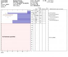 |
Forecaster |
|
02/21/2021 - 10:30 Avalanche Observation |
Incline Peak Mount Rose Area |
Public | |
|
02/20/2021 - 14:45 Snowpack Observation |
Backside of Incline Peak Mount Rose Area |
  |
Public |
|
02/20/2021 - 14:36 Avalanche Observation |
1/4 mile north of mt Lola Little Truckee Summit Areas |
  |
Public |
|
02/20/2021 - 13:56 Snowpack Observation |
Observation point Shirley canyon Cabin Creek, Deep Creek, or Pole Creek Area |
 |
Guide Alpenglow Expeditio |
|
02/20/2021 - 13:30 Avalanche Observation |
Horse Canyon Bear Valley Area |
Public | |
|
02/20/2021 - 12:30 Snowpack Observation |
Tragedy Springs Carson Pass Area |
  |
Public |
|
02/20/2021 - 10:30 Snowpack Observation |
Saddle between Scotts Lake and Big Meadow Carson Pass Area |
 |
Public |
|
02/20/2021 - 09:00 Snowpack Observation |
Andesite Peak Donner Summit Area |
     |
Forecaster |
|
02/19/2021 - 16:00 Snowpack Observation |
Mt tamarack Mount Rose Area |
 |
Public |
|
02/19/2021 - 11:30 Snowpack Observation |
Tamarack Peak Mount Rose Area |
       |
Forecaster |
|
02/19/2021 - 09:00 Snowpack Observation |
Hope Valley / Tamarack Junction Carson Pass Area |
Public | |
|
02/19/2021 - 07:00 Avalanche Observation |
Tamarack Peak Mount Rose Area |
 |
Public |


This website is owned and maintained by the non-profit arm of the Sierra Avalanche Center. Some of the content is updated by the USDA avalanche forecasters including the forecasts and some observational data. The USDA is not responsible for any advertising, fund-raising events/information, or sponsorship information, or other content not related to the forecasts and the data pertaining to the forecasts.