THIS AVALANCHE FORECAST EXPIRED ON March 7, 2014 @ 7:00 am
Avalanche Forecast published on March 6, 2014 @ 7:00 am
Issued by Andy Anderson - Tahoe National Forest - Sierra Avalanche Center

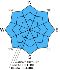
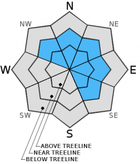
MODERATE avalanche danger still exists at all elevations and on all aspects on slopes 35 degrees and steeper due to a mix of loose wet snow and wind slabs.

2. Moderate

?

Above Treeline
Heightened avalanche conditions on specific terrain features. Evaluate snow and terrain carefully; identify features of concern.

2. Moderate

?

Near Treeline
Heightened avalanche conditions on specific terrain features. Evaluate snow and terrain carefully; identify features of concern.

2. Moderate

?

Below Treeline
Heightened avalanche conditions on specific terrain features. Evaluate snow and terrain carefully; identify features of concern.
    Heightened avalanche conditions on specific terrain features. Evaluate snow and terrain carefully; identify features of concern.
Avalanche Problem 1: Loose Wet
  • Type ?
  • Aspect/Elevation ?
  • Likelihood ?
    Certain
    Very Likely
    Likely
    Possible
    Unlikely
  • Size ?
    Historic
    Very Large
    Large
    Small

Rain on snow and warm temperatures should have prevented much of a refreeze last night meaning that wet snow remains widespread across all aspects below 8500 ft. Human triggered loose wet avalanche activity will remain possible on slopes 35 degrees and steeper on all aspects below 8500 ft. Some natural loose wet avalanche activity could also occur. Most of these wet snow instabilities should remain limited to roller balls, pinwheels, and small wet snow sluffs, but some of them could entrain enough snow to cause problems for backcountry travelers. Wet slab avalanche activity should remain unlikely but isolated wet slabs are not impossible today.

Avalanche Problem 2: Wind Slab
  • Type ?
  • Aspect/Elevation ?
  • Likelihood ?
    Certain
    Very Likely
    Likely
    Possible
    Unlikely
  • Size ?
    Historic
    Very Large
    Large
    Small

Above 8500 ft. new snow and strong winds could have formed new winds slabs on the leeward NW-N-NE-E-SE aspects in near and above treeline terrain. These wind slabs should remain small due to the small amounts of new snow received overnight but could reach up to 1 ft. in depth in some areas. Human triggering of these wind slabs will be possible today.

recent observations

Yesterday wet snow existed on all aspects near Becker Peak and on Tamarack Peak. Ski cuts triggered loose wet roller balls at all elevations in both areas. In the Becker Peak area some larger wet snow sluffs resulted from ski cuts on steep N-NE facing tests slopes and pinwheels up to 8 ft. in diameter resulted from dropping small cornice pieces onto slopes. General observations in both areas and formal snowpit tests on Tamarack Peak did not indicate any slab instabilities.

Weather and CURRENT CONDITIONS
weather summary

A warm wet storm delivered rain and strong winds to the forecast area overnight. .5 to 1 inch of water fell during the night. Most of this precipitation fell as rain since snow levels remained above 9000. ft for most of the night. By the early morning hours, temperatures and snow levels did fall allowing 2-4 inches of snow to accumulate above 8500 ft. By the time snow level fell lower, most of the precipitation had already stopped. Some scattered rain and snow showers and strong southwest winds should continue today before this system moves out of the area. Daytime highs should climb into the upper 30's and low 40's above 7000 ft. today. Skies should start to clear up overnight and temperatures should drop into the 20's. By tomorrow the forecast calls for sunny skies and light to moderate east winds as a high pressure ridge rebuilds over the region.

CONDITIONS ALONG THE SIERRA CREST BETWEEN 8200 FT. AND 9200 FT. IN THE LAST 24 HOURS
6am temperature: 26 to 34 deg. F.
Max. temperature: 37 to 46 deg. F.
Average ridgetop wind direction: Southwest
Average ridgetop wind speed: 40 to 50 mph
Maximum ridgetop wind gust: 83 mph
New snowfall: Below 8500 ft: .5-1 inches of rain | Above 8500 ft: Snow 2 to 4 inches
Total snow depth: 45 to 58 inches
Two-Day Mountain Weather Forecast Produced in partnership with the Reno NWS
For 7000 ft. to 8000 ft.
Thursday Thursday Night Friday
Weather: Mostly cloudy with scattered snow showers Partly cloudy Sunny
Temperatures: 36 to 43 deg. F. 18 to 25 deg. F. 39 to 46 deg. F.
Mid Slope Winds: Southwest West East
Wind Speed: 35 to 40 mph with gusts to 70 mph decreasing to 60 mph in the afternoon 20 to 25 mph with gusts to 40 mph decreasing to 10 to 15 mph after midnight 10 to 15 mph with gusts to 25 mph in the morning
Expected snowfall: 0 0 0
For 8000 ft. to 9000 ft.
Thursday Thursday Night Friday
Weather: Mostly cloudy with scattered snow showers Partly cloudy Sunny
Temperatures: 37 to 43 deg. F. 17 to 24 deg. F. 34 to 41 deg. F.
Ridge Top Winds: Southwest West shifting to the northwest after midnight East
Wind Speed: 50 to 65 mph with gusts to 90 mph 30 to 40 mph with gusts to 60 mph decreasing to 15 to 20 mph after midnight 15 to 20 mph with gusts to 30 mph
Expected snowfall: 0 0 0
Disclaimer

This avalanche advisory is provided through a partnership between the Tahoe National Forest and the Sierra Avalanche Center. This advisory covers the Central Sierra Nevada Mountains between Yuba Pass on the north and Ebbetts Pass on the south. Click here for a map of the forecast area. This advisory applies only to backcountry areas outside established ski area boundaries. This advisory describes general avalanche conditions and local variations always occur. This advisory expires 24 hours after the posted time unless otherwise noted. The information in this advisory is provided by the USDA Forest Service who is solely responsible for its content.