THIS AVALANCHE FORECAST EXPIRED ON April 15, 2014 @ 6:54 am
Avalanche Forecast published on April 14, 2014 @ 6:54 am
Issued by Brandon Schwartz - Tahoe National Forest

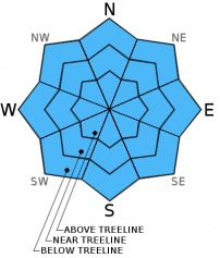
Early this morning, avalanche danger is LOW for all elevations and aspects. In response to daytime warming, pockets of MODERATE danger will form on all aspects at all elevations on slopes 37 degrees and steeper. Human triggered loose wet avalanches are possible. Natural avalanches are unlikely.

2. Moderate

?

Above Treeline
Heightened avalanche conditions on specific terrain features. Evaluate snow and terrain carefully; identify features of concern.

2. Moderate

?

Near Treeline
Heightened avalanche conditions on specific terrain features. Evaluate snow and terrain carefully; identify features of concern.

2. Moderate

?

Below Treeline
Heightened avalanche conditions on specific terrain features. Evaluate snow and terrain carefully; identify features of concern.
    Heightened avalanche conditions on specific terrain features. Evaluate snow and terrain carefully; identify features of concern.
Avalanche Problem 1: Loose Wet
  • Type ?
  • Aspect/Elevation ?
  • Likelihood ?
    Certain
    Very Likely
    Likely
    Possible
    Unlikely
  • Size ?
    Historic
    Very Large
    Large
    Small

A decent to fairly good snow surface refreeze is expected to have occurred last night with near freezing air temperatures and clear skies. As daytime warming progresses, snow surface melt will allow for human triggered loose wet avalanches to become possible on all aspects at all elevations. Any avalanches that occur today are expected to be small. Once last night's snow surface refreeze is fully melted and the snowpack becomes unsupportable, move to more northerly aspects or exit from in or below avalanche terrain for the remainder of the day.

recent observations

Observations made yesterday on Stevens Peak (Carson Pass area) revealed that a decent overnight refreeze had occurred in the area. Snow surface conditions remained supportable on all aspects until about noon and remained supportable longer on northerly aspects above 8,200'. Ski cuts on steep NE aspects at 8,000' to 8,200' at 12:30 pm produced only very limited wet snow instability in the form of small roller balls and tiny loose wet avalanches despite deep ski and boot penetration into wet snow. Significant snowpack melt has occurred in this area. Most areas of continuous snowcover are limited to NW-N-NE and previously wind loaded E aspects above 8,200'.

Yesterday on Powderhouse Peak (Luther Pass area), observations targeting the old near crust facets in the upper portion of the snowpack revealed isolated evidence of instability on a N aspect in an area near the valley floor (about 8,000'), likely due to cold air pooling.

Weather and CURRENT CONDITIONS
weather summary

High pressure in place over the forecast area will provide sunny skies and above average air temperatures for today. Remote sensors between 8,200' and 9,600' and reporting air temperatures in the low 30s this morning. Maximum daytime air temperatures are expected to reach the upper 40s to upper 50s today for areas above 7,000'. Ridgetop winds remain out of the northeast this morning, but are forecast to shift to the southwest by this afternoon. Moderate speed winds are expected over the higher elevation ridgetops this afternoon. Light winds are expected elsewhere.

CONDITIONS ALONG THE SIERRA CREST BETWEEN 8200 FT. AND 9200 FT. IN THE LAST 24 HOURS
6am temperature: 30 to 33 deg. F.
Max. temperature: 48 to 53 deg. F.
Average ridgetop wind direction: Northeast
Average ridgetop wind speed: 22 mph
Maximum ridgetop wind gust: 35 mph
New snowfall: 0 inches
Total snow depth: 25 to 56 inches
Two-Day Mountain Weather Forecast Produced in partnership with the Reno NWS
For 7000 ft. to 8000 ft.
Monday Monday Night Tuesday
Weather: Sunny skies. Partly cloudy skies. Partly cloudy skies.
Temperatures: 54 to 60 deg. F. 31 to 37 deg. F. 53 to 59 deg. F.
Mid Slope Winds: Northeast shifting to southwest Southwest Southwest
Wind Speed: Light winds 10 to 15 mph. Gusts to 25 mph after midnight. 15 to 20 mph with gusts to 30 mph.
Expected snowfall: 0 0 0
For 8000 ft. to 9000 ft.
Monday Monday Night Tuesday
Weather: Sunny skies. Partly cloudy skies. Partly cloudy skies.
Temperatures: 48 to 54 deg. F. 30 to 34 deg. F. 47 to 53 deg. F.
Ridge Top Winds: Northeast shifting to southwest. West to southwest West
Wind Speed: Light winds increasing to 10 to 15 mph with gusts to 25 mph in the afternoon. 10 to 15 mph with gusts to 25 mph, increasing to 20 to 25 mph with gusts to 35 mph after midnight. 20 to 30 mph with gust to 45 mph.
Expected snowfall: 0 0 0
Disclaimer

This avalanche advisory is provided through a partnership between the Tahoe National Forest and the Sierra Avalanche Center. This advisory covers the Central Sierra Nevada Mountains between Yuba Pass on the north and Ebbetts Pass on the south. Click here for a map of the forecast area. This advisory applies only to backcountry areas outside established ski area boundaries. This advisory describes general avalanche conditions and local variations always occur. This advisory expires 24 hours after the posted time unless otherwise noted. The information in this advisory is provided by the USDA Forest Service who is solely responsible for its content.