THIS AVALANCHE FORECAST EXPIRED ON December 17, 2014 @ 6:51 am
Avalanche Forecast published on December 16, 2014 @ 6:51 am
Issued by Andy Anderson - Tahoe National Forest - Sierra Avalanche Center

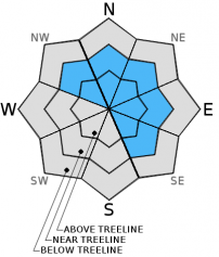
Human-triggered wind slab avalanches are possible (MODERATE avalanche danger) on wind-loaded NW-N-NE-E aspects 35 degrees and steeper in near and above treeline terrain. Due to shifting winds some isolated pockets of wind slabs may exist on SE aspects in near and above treeline terrain. Use clues like cornices, drifted snow, ripples in the snow surface, and other wind created textures to help determine where wind slabs may exist.

2. Moderate

?

Above Treeline
Heightened avalanche conditions on specific terrain features. Evaluate snow and terrain carefully; identify features of concern.

2. Moderate

?

Near Treeline
Heightened avalanche conditions on specific terrain features. Evaluate snow and terrain carefully; identify features of concern.

1. Low

?

Below Treeline
Generally safe avalanche conditions. Watch for unstable snow on isolated terrain features.
    Heightened avalanche conditions on specific terrain features. Evaluate snow and terrain carefully; identify features of concern.
Avalanche Problem 1: Wind Slab
  • Type ?
  • Aspect/Elevation ?
  • Likelihood ?
    Certain
    Very Likely
    Likely
    Possible
    Unlikely
  • Size ?
    Historic
    Very Large
    Large
    Small

Human-triggered avalanches involving the wind slabs that formed over the last 24 hours will remain possible today. These wind slabs rest on a layer of softer snow that can serve as a weak layer. Wind-loaded NW-N-NE-E aspects in near and above treeline terrain represent the most likely places to find wind slabs today. However, some cross-loaded SE may hold small wind slabs as well. Due to winds shifting between south and southwest during the storm wind slabs may have formed in some atypical areas. Use clues like cornices, drifted snow, ripples in the snow surface, and other wind created textures to help determine where wind slabs may exist. Most of these wind slabs should not extend too far down slope but many of them could be 1 to 2 ft. in depth. In the most heavily wind-loaded areas or in areas where terrain traps magnify the consequences of the wind slabs, they could involve enough snow to bury a person. 

recent observations

Yesterday more snow than expected created larger wind slabs than expected. On Mt. Judah wind slabs 6 to 12 inches in depth existed on the N-NE-ENE aspects in near and above treeline terrain. Several small skier-triggered avalanches occurred on wind-loaded test slopes and a few small wind slabs failed due to natural cornice failures. A layer of softer snow below the wind slabs served as the weak layer in all of these wind slab failures. Check out yesterday's observations for photos, videos, and more information. 

Weather and CURRENT CONDITIONS
weather summary

4 to 7 inches of new snow has accumulated during the last 24 hours. Some snow showers may linger around the forecast area through mid morning especially along the Sierra Crest and in areas east of Lake Tahoe affected by lake effect snow. The snow should diminish through the morning, and the area should see a break in precipitation this afternoon. The forecast calls for light accumulations up to 1 inch during the day today with a slight chance of up to 3 inches in some areas. By this evening another small storm should arrive over the region bringing more snow and increased south and southwest winds. Most of the snow associated with this system should fall late tonight and early tomorrow morning. The forecast calls for another 3 to 7 inches by mid day on Wednesday. This storm should continue moving east tomorrow and snow showers and winds should decrease during the day.

CONDITIONS ALONG THE SIERRA CREST BETWEEN 8200 FT. AND 9200 FT. IN THE LAST 24 HOURS
6am temperature: 22 to 28 deg. F.
Max. temperature: 24 to 36 deg. F.
Average ridgetop wind direction: South and Southwest
Average ridgetop wind speed: 25 to 35 mph
Maximum ridgetop wind gust: 61 mph
New snowfall: 4 to 7 inches
Total snow depth: 24 to 39 inches
Two-Day Mountain Weather Forecast Produced in partnership with the Reno NWS
For 7000 ft. to 8000 ft.
Tuesday Tuesday Night Wednesday
Weather: Cloudy with scattered snow showers Cloudy with snow likely Cloudy with a chance of snow showers
Temperatures: 26 to 33 deg. F. 17 to 24 deg. F. 24 to 31 deg. F.
Mid Slope Winds: Southwest South Southwest
Wind Speed: 15 to 20 mph with gusts to 30 mph 15 to 25 mph with gusts 35 mph 10 to 15 mph in the morning becoming light in the afternoon
Expected snowfall: up to 1 2 to 6 up to 1
For 8000 ft. to 9000 ft.
Tuesday Tuesday Night Wednesday
Weather: Cloudy with scattered snow showers Cloudy with snow likely Cloudy with a chance of snow showers
Temperatures: 23 to 30 deg. F. 15 to 22 deg. F. 21 to 28 deg. F.
Ridge Top Winds: Southwest South Southwest
Wind Speed: 15 to 20 mph increasing to 25 to 30 mph in the afternoon. Gusts up to 40 mph 20 to 30 mph with gusts to 45 mph 15 to 20 mph with gusts to 30 mph in the morning
Expected snowfall: up to 1 2 to 6 up to 1
Disclaimer

This avalanche advisory is provided through a partnership between the Tahoe National Forest and the Sierra Avalanche Center. This advisory covers the Central Sierra Nevada Mountains between Yuba Pass on the north and Ebbetts Pass on the south. Click here for a map of the forecast area. This advisory applies only to backcountry areas outside established ski area boundaries. This advisory describes general avalanche conditions and local variations always occur. This advisory expires 24 hours after the posted time unless otherwise noted. The information in this advisory is provided by the USDA Forest Service who is solely responsible for its content.