THIS AVALANCHE FORECAST EXPIRED ON January 2, 2016 @ 6:53 am
Avalanche Forecast published on December 31, 2015 @ 6:53 am
Issued by Andy Anderson - Tahoe National Forest - Sierra Avalanche Center

This advisory will cover Dec. 31 and Jan. 1. The next update to the avalanche advisory will occur on Jan. 2 at 7:00 am. 

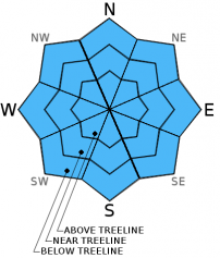
The avalanche danger remains low on all aspects and elevations. While avalanches remain unlikely, some unstable snow could linger on isolated terrain features. Continue to use normal caution when traveling in the backcountry.

1. Low

?

Above Treeline
Generally safe avalanche conditions. Watch for unstable snow on isolated terrain features.

1. Low

?

Near Treeline
Generally safe avalanche conditions. Watch for unstable snow on isolated terrain features.

1. Low

?

Below Treeline
Generally safe avalanche conditions. Watch for unstable snow on isolated terrain features.
    Generally safe avalanche conditions. Watch for unstable snow on isolated terrain features.
Avalanche Problem 1: Normal Caution
  • Type ?
  • Aspect/Elevation ?
  • Likelihood ?
    Certain
    Very Likely
    Likely
    Possible
    Unlikely
  • Size ?
    Historic
    Very Large
    Large
    Small

Avalanches will remain unlikely, and avalanche problems will remain limited today and tomorrow. In most areas observations have shown a well bonded snowpack with a variety of snow surface conditions. In near and below treeline areas sheltered from the scouring winds, 12 to 15 inches of soft unconsolidated snow exists on the snow on top of the snowpack. In more exposed near and above treeline areas, firm wind scoured surfaces or exposed icy crusts comprise the snow surface. Arresting a fall on some of these icy exposed slopes may be difficult. As the winds shift back and forth from east to south and southwest between today and tomorrow, some minor wind slabs may form on some of the upper elevation slopes near ridgelines. These wind slabs should remain small, shallow, and not extend very far away from the ridgelines due to previous scouring that reduced the amount of snow available for transport. Some cornices still loom over previously wind loaded slopes as well. 

Continue to practice normal caution and safe travel techniques when traveling in the backcountry. Those techniques include avoiding areas of unstable snow, only exposing one person at a time to avalanche terrain, regrouping in safe spots out of the avalanche path, avoiding terrain traps, and communicating clearly with your partners.

recent observations

Yesterday on Andesite Ridge and Waterhouse observations showed soft unconsolidated snow in sheltered areas on all aspects and wind scoured surfaces and exposed crusts on near and above treeline open slopes. Some wind transport did start occurring along the summit ridgeline of Waterhouse Peak and along some of the upper elevation peaks around Carson Pass during the afternoon, but new wind slab formation remained minimal due to the lack of snow available for transport. Ski cuts and general observations on both Andesite and Waterhouse did not reveal any signs of instabilities. Snowpit data from Andesite Ridge showed a well-bonded snowpack and did not reveal any layers/interfaces of concern.

Weather and CURRENT CONDITIONS
weather summary

The winds shifted back to the east yesterday around 4 pm as a cold, dry low pressure system moved into the region. While some cloud cover and very light snow with no accumulation may accompany this system tonight, expect partly cloudy to mostly sunny skies today, tomorrow and Saturday. Temperatures should stay cold for the next few days as well. Daytime highs above 7000 ft. should remain in the teens today, tomorrow, and Saturday, while overnight lows drop into the single digits. Expect to see even colder temperatures in the valleys as cold air becomes trapped at the lower elevations. The winds should remain out of the east and southeast until Friday night or Saturday when they will shift back towards the south and southwest. 

CONDITIONS ALONG THE SIERRA CREST BETWEEN 8200 FT. AND 9200 FT. IN THE LAST 24 HOURS
6am temperature: 11 to 16 deg. F.
Max. temperature: 20 to 30 deg. F.
Average ridgetop wind direction: Southwest until 4pm yesterday then east
Average ridgetop wind speed: 15 to 25 mph
Maximum ridgetop wind gust: 41 mph
New snowfall: 0 inches
Total snow depth: 48 to 59 inches
Two-Day Mountain Weather Forecast Produced in partnership with the Reno NWS
For 7000 ft. to 8000 ft.
Thursday Thursday Night Friday
Weather: Partly cloudy to mostly sunny Partly cloudy with a 15% chance of very light snow Partly cloudy to mostly sunny
Temperatures: 17 to 24 deg. F. 3 to 11 deg. F. 14 to 21 deg. F.
Mid Slope Winds: East East East
Wind Speed: 10 to 15 mph 15 to 20 mph with gusts to 30 mph 15 to 20 mph with gusts to 30 mph
Expected snowfall: 0 0 0
For 8000 ft. to 9000 ft.
Thursday Thursday Night Friday
Weather: Partly cloudy to mostly sunny Partly cloudy with a 15% chance of very light snow Partly cloudy to mostly sunny
Temperatures: 16 to 23 deg. F. 6 to 12 deg. F. 13 to 20 deg. F.
Ridge Top Winds: East East East shifting to southeast in the afternoon
Wind Speed: 15 to 20 mph with gusts to 30 mph 20 to 25 mph with gusts to 35 mph 20 to 25 mph with gusts to 35 mph decreasing to 10 to 15 mph with gusts to 25 mph in the afternoon
Expected snowfall: 0 0 0
Disclaimer

This avalanche advisory is provided through a partnership between the Tahoe National Forest and the Sierra Avalanche Center. This advisory covers the Central Sierra Nevada Mountains between Yuba Pass on the north and Ebbetts Pass on the south. Click here for a map of the forecast area. This advisory applies only to backcountry areas outside established ski area boundaries. This advisory describes general avalanche conditions and local variations always occur. This advisory expires 24 hours after the posted time unless otherwise noted. The information in this advisory is provided by the USDA Forest Service who is solely responsible for its content.