THIS AVALANCHE FORECAST EXPIRED ON February 17, 2015 @ 6:30 am
Avalanche Forecast published on February 16, 2015 @ 6:30 am
Issued by Andy Anderson - Tahoe National Forest - Sierra Avalanche Center

Avalanche danger should remain LOW for all elevations and aspects again today. While avalanches are unlikely, a few scattered loose wet avalanches are not impossible on some isolated terrain features. Use normal caution when traveling in the backcountry.

1. Low

?

Above Treeline
Generally safe avalanche conditions. Watch for unstable snow on isolated terrain features.

1. Low

?

Near Treeline
Generally safe avalanche conditions. Watch for unstable snow on isolated terrain features.

1. Low

?

Below Treeline
Generally safe avalanche conditions. Watch for unstable snow on isolated terrain features.
    Generally safe avalanche conditions. Watch for unstable snow on isolated terrain features.
Avalanche Problem 1: Loose Wet
  • Type ?
  • Aspect/Elevation ?
  • Likelihood ?
    Certain
    Very Likely
    Likely
    Possible
    Unlikely
  • Size ?
    Historic
    Very Large
    Large
    Small

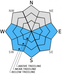
Another refreeze should have occurred last night since the clear skies allowed the snowpack to radiate heat out into the night. While slightly cooler temperatures and light to moderate winds should help keep the snow surface from melting too quickly, today's sunny skies and warm temperatures will still cause wet snow to form by mid-morning. Despite the wet snow formation, wet snow instabilities should remain limited since the snowpack has already been through so many melt freeze cycles and the sun still remains relatively low in the sky. If any wet snow instabilities do occur today, human triggered roller balls and pinwheels should represent the majority of them. Actual loose wet avalanches are unlikely but not impossible. The sun-exposed E-SE-S-SW-W aspects will represent the best places to find wet snow instabilities today.

recent observations

The wind scoured SW-W aspects of Castle Peak held 2-4 inches of soft corn snow above a supportable base by 2:30 pm yesterday. Some minor softening also occurred on the NW aspects. Ski cuts and general observations on these aspects did not reveal significant signs of wet snow instabilities. On more northerly aspects of Castle Peak, the snow surface was a mix of firm melt freeze crusts and soft wet snow. Snowpit data on a NNW aspect at 8500 ft. showed a well bonded and strong snowpack consisting of the softer surface snow above a thick rain crust with wet snow below that.

Weather and CURRENT CONDITIONS
weather summary

The high pressure ridge will keep the weather warm, dry, and clear over the region. Today's highs should be slightly cooler than yesterday's with temperatures reaching into the mid to upper 40's above 7000 ft. Tomorrow, expect a few degrees of warming as temperatures climb into the upper 40's and low 50's above 7000 ft. Light to moderate winds shifting between the northwest, east, and southwest should continue through tomorrow at the higher elevations.

CONDITIONS ALONG THE SIERRA CREST BETWEEN 8200 FT. AND 9200 FT. IN THE LAST 24 HOURS
6am temperature: 33 to 42 deg. F.
Max. temperature: 47 to 50 deg. F.
Average ridgetop wind direction: East shifting to southwest
Average ridgetop wind speed: 15 to 20 mph
Maximum ridgetop wind gust: 45 mph
New snowfall: 0 inches
Total snow depth: 29 to 45 inches
Two-Day Mountain Weather Forecast Produced in partnership with the Reno NWS
For 7000 ft. to 8000 ft.
Monday Monday Night Tuesday
Weather: Sunny Clear Sunny
Temperatures: 43 to 50 deg. F. 25 to 32 deg. F. 46 to 53 deg. F.
Mid Slope Winds: Variable Variable Variable
Wind Speed: Light Light Light
Expected snowfall: 0 0 0
For 8000 ft. to 9000 ft.
Monday Monday Night Tuesday
Weather: Sunny Clear Sunny
Temperatures: 40 to 47 deg. F. 27 to 34 deg. F. 42 to 49 deg. F.
Ridge Top Winds: Northwest East Southwest
Wind Speed: 10 to 15 mph with gusts to 25 mph 10 to 15 mph with gusts to 25 mph 10 to 15 mph with gusts to 25 mph in the afternoon
Expected snowfall: 0 0 0
Disclaimer

This avalanche advisory is provided through a partnership between the Tahoe National Forest and the Sierra Avalanche Center. This advisory covers the Central Sierra Nevada Mountains between Yuba Pass on the north and Ebbetts Pass on the south. Click here for a map of the forecast area. This advisory applies only to backcountry areas outside established ski area boundaries. This advisory describes general avalanche conditions and local variations always occur. This advisory expires 24 hours after the posted time unless otherwise noted. The information in this advisory is provided by the USDA Forest Service who is solely responsible for its content.