THIS AVALANCHE FORECAST EXPIRED ON March 25, 2015 @ 7:00 am
Avalanche Forecast published on March 24, 2015 @ 7:00 am
Issued by Andy Anderson - Tahoe National Forest - Sierra Avalanche Center

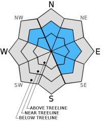
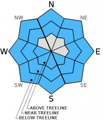
The avalanche danger should remain LOW in most places today. Small human triggerable wind slabs may linger on isolated terrain features on previously wind loaded NW-N-NE-E-SE aspects in near and above treeline terrain. These terrain features could include extreme or complex terrain, wind loaded slopes above cliffs, other unsupported slopes, couliors, and gullies. If enough warming occurs today, some small isolated loose wet snow instabilities may also form.

1. Low

?

Above Treeline
Generally safe avalanche conditions. Watch for unstable snow on isolated terrain features.

1. Low

?

Near Treeline
Generally safe avalanche conditions. Watch for unstable snow on isolated terrain features.

1. Low

?

Below Treeline
Generally safe avalanche conditions. Watch for unstable snow on isolated terrain features.
    Generally safe avalanche conditions. Watch for unstable snow on isolated terrain features.
Avalanche Problem 1: Wind Slab
  • Type ?
  • Aspect/Elevation ?
  • Likelihood ?
    Certain
    Very Likely
    Likely
    Possible
    Unlikely
  • Size ?
    Historic
    Very Large
    Large
    Small

While triggering a small wind slab has become unlikely in most areas today, some small human triggerable wind slabs may linger on isolated terrain features on some wind loaded and cross loaded NW-N-NE-E-SE aspects. The isolated terrain features where small unstable wind slabs may linger include extreme or complex terrain, wind loaded slopes above cliffs, other unsupported slopes, couliors, and gullies near ridge lines along the Sierra Crest. This kind of terrain magnifies the consequences of small avalanches. Most of the wind slabs that have formed remain relatively small and do not extend very far down slope. In some of the more heavily wind loaded areas where the most new snow fell, wind slabs around a foot in depth may exist.

Avalanche Problem 2: Loose Wet
  • Type ?
  • Aspect/Elevation ?
  • Likelihood ?
    Certain
    Very Likely
    Likely
    Possible
    Unlikely
  • Size ?
    Historic
    Very Large
    Large
    Small

Some loose wet snow instabilities may start to occur this afternoon if enough daytime warming occurs. These wet snow instabilities should remain limited to small loose wet snow sluffs, pinwheels, and roller balls. While wet snow could form on any aspect, most of the wet snow activity should remain limited to slopes below 8000 ft. If the day warms up more than expected or the sunshine breaks through the clouds earlier than expected, wet snow instabilities could become more widespread.

recent observations

Yesterday on Andesite Ridge the new snow fell on bare ground in some places and on warm melt-freeze crusts in other places. The storm deposited a lighter softer layer of snow at first. A heavier layer of snow that fell later in the storm existed on top of that lighter layer. Skier triggered shooting cracks and unstable snowpit test results did occur on wind loaded test slopes in near and above treeline terrain. The winds slabs measured about 1 ft. in depth and did not extend very far down slope. In non wind loaded areas, some small loose wet snow sluffs started to occur on very steep test slopes during the afternoon as the day warmed up.

Weather and CURRENT CONDITIONS
weather summary

Another 1 to 2 inches of snow fell along the Sierra Crest yesterday before the storm dissipated. Snow totals ranged from 4 to 6 inches along the Sierra Crest to 3 to 5 inches in areas east of Lake Tahoe. The winds started to decrease during the night and should continue to diminish today. Another low pressure sliding across northern CA and the Pacific Northwest should allow cloud cover to persist over the region today. Most of the precipitation associated with this system should stay well north of the forecast area, but a few isolated snow showers could be possible this afternoon in this region. This instability and cloud cover should keep daytime highs in the mid 30's to mid 40's above 7000 ft. today. Another high pressure ridge will start to form over the region tonight bringing clearing skies and north and east winds. By tomorrow expect sunny skies, light east winds, and daytime highs in the mid to upper 40's above 7000 ft.

CONDITIONS ALONG THE SIERRA CREST BETWEEN 8200 FT. AND 9200 FT. IN THE LAST 24 HOURS
6am temperature: 24 to 30 deg. F.
Max. temperature: 27 to 37 deg. F.
Average ridgetop wind direction: Southwest to west
Average ridgetop wind speed: 25 to 30 mph
Maximum ridgetop wind gust: 63 mph
New snowfall: 0 to 2 inches
Total snow depth: 18 to 42 inches
Two-Day Mountain Weather Forecast Produced in partnership with the Reno NWS
For 7000 ft. to 8000 ft.
Tuesday Tuesday Night Wednesday
Weather: Mostly cloudy with a slight chance for isolated snow showers in the afternoon Mostly cloudy becoming partly cloudy Partly cloudy to mostly sunny
Temperatures: 40 to 46 deg. F. 23 to 29 deg. F. 43 to 50 deg. F.
Mid Slope Winds: West Northwest East
Wind Speed: 15 to 20 mph with gusts to 30 mph 10 to 15 mph in the evening becoming light Light in the morning increasing to 10 to 15 mph in the afternoon
Expected snowfall: 0 0 0
For 8000 ft. to 9000 ft.
Tuesday Tuesday Night Wednesday
Weather: Mostly cloudy with a slight chance for isolated snow showers in the afternoon Mostly cloudy becoming partly cloudy Partly cloudy to mostly sunny
Temperatures: 34 to 42 deg. F. 20 to 27 deg. F. 41 to 48 deg. F.
Ridge Top Winds: West North East
Wind Speed: 25 to 30 mph with gusts to 45 mph decreasing to 15 to 20 mph with gusts to 30 mph in the afternoon 10 to 15 mph with gusts to 25 mph 15 to 20 mph with gusts to 30 mph in the afternoon
Expected snowfall: 0 0 0
Disclaimer

This avalanche advisory is provided through a partnership between the Tahoe National Forest and the Sierra Avalanche Center. This advisory covers the Central Sierra Nevada Mountains between Yuba Pass on the north and Ebbetts Pass on the south. Click here for a map of the forecast area. This advisory applies only to backcountry areas outside established ski area boundaries. This advisory describes general avalanche conditions and local variations always occur. This advisory expires 24 hours after the posted time unless otherwise noted. The information in this advisory is provided by the USDA Forest Service who is solely responsible for its content.