THIS AVALANCHE FORECAST EXPIRED ON April 10, 2016 @ 6:42 am
Avalanche Forecast published on April 9, 2016 @ 6:42 am
Issued by Brandon Schwartz - Tahoe National Forest

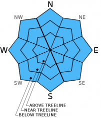
MODERATE avalanche danger continues for all aspects below 9,500' on slopes 35 degrees and steeper due to ongoing loose wet avalanche problems. Little to no snow surface refreeze is expected to have occurred last night. The minimal amount of new snow that deposits over the highest elevations today is not expected to create new avalanche problems. Evaluate snow and terrain carefully. Identify and avoid the areas where wet snow depth is sufficient for loose wet avalanches to occur.

2. Moderate

?

Above Treeline
Heightened avalanche conditions on specific terrain features. Evaluate snow and terrain carefully; identify features of concern.

2. Moderate

?

Near Treeline
Heightened avalanche conditions on specific terrain features. Evaluate snow and terrain carefully; identify features of concern.

2. Moderate

?

Below Treeline
Heightened avalanche conditions on specific terrain features. Evaluate snow and terrain carefully; identify features of concern.
    Heightened avalanche conditions on specific terrain features. Evaluate snow and terrain carefully; identify features of concern.
Avalanche Problem 1: Loose Wet
  • Type ?
  • Aspect/Elevation ?
  • Likelihood ?
    Certain
    Very Likely
    Likely
    Possible
    Unlikely
  • Size ?
    Historic
    Very Large
    Large
    Small

Rain on snow below 9,000' will continue to melt and weaken the snowpack today. Areas above 9,500' may slowly refreeze today, or at least stop producing free water. Free water drainage is fairly well established on E-SE-S-SW-W aspects at all elevations. Free water drainage is not yet established above 8,000' on NW-N-NE aspects. All aspects that did not refreeze last night and remain unfrozen today will be prone to wet snow instability. Rain on snow on NW-N-NE aspects above 8,000' will be particularly prone to wet snow instability today. The vast majority of today's instability is expected to take the form of loose wet avalanches, however isolated wet slab and glide avalanches are not impossible.

Widespread areas of deep wet snow are expected first thing this morning and all day today. Some weak and superficial snow surface refreeze may have occurred last night over the northern portion of the forecast area where cloud cover was thin. This weak and superficial refreeze is not expected to provide a workable window of quality travel conditions this morning. Evaluate areas of wet snow today for supportability. If in doubt, step off of equipment and observed the depth of body weight boot penetration into wet snow. Anything deeper than 8 to 10 inches is problematic. Avoid travel on or below slopes 35 degrees and steeper when deep wet snow conditions are present.

recent observations

Observations made yesterday on Relay Peak (Mount Rose area) indicated that a poor snow surface refreeze had occurred in the area Thursday night. Deep wet snow conditions existed at the trailhead by 10:30 am. By 11:45 am, very few areas of supportable crust remained on E-SE-S aspects. Ski cuts on E-SE aspect test slopes at 9,100' produced loose wet avalanches at 11:25 am. On N aspects at 9,600', surface melt freeze conditions had only affected the top 2 to 3 inches of the snowpack. Snow below the surface crust had yet to undergo melt-freeze. Snow on upper elevation N aspects in this area is in poor condition to handle a rain on snow event.

Weather and CURRENT CONDITIONS
weather summary

A cut off low pressure system sitting to the west of Baja/SoCal will move east today. Moisture associated with the system is moving into the forecast area from the south. Light rain and snow showers are occurring this morning over the southern half of the forecast area. Snow level is running 8,500' to 9,000'. Significantly colder air is not associated with this system so snow levels will remain high today. Maximum daytime air temperatures are expected in the mid 30s to mid 40s today for areas above 7,000'. Ridgetop winds are expected to remain light in speed out of the SW. Snow level is expected to lower a bit tonight, but snowfall accumulation will remain light and limited to areas above 8,000'.

CONDITIONS ALONG THE SIERRA CREST BETWEEN 8200 FT. AND 9200 FT. IN THE LAST 24 HOURS
6am temperature: 36 to 40 deg. F.
Max. temperature: 52 to 55 deg. F.
Average ridgetop wind direction: SW
Average ridgetop wind speed: 7 mph
Maximum ridgetop wind gust: 29 mph
New snowfall: 0 inches
Total snow depth: 63 to 106 inches
Two-Day Mountain Weather Forecast Produced in partnership with the Reno NWS
For 7000 ft. to 8000 ft.
Saturday Saturday Night Sunday
Weather: Cloudy skies with rain showers. Mostly cloudy skies with rain showers in the evening. A chance of rain showers after midnight. Mostly cloudy skies with a chance of rain showers in the morning. Rain showers likely in the afternoon.
Temperatures: 39 to 45 deg. F. 33 to 36 deg. F. 40 to 47 deg. F.
Mid Slope Winds: W W Variable
Wind Speed: Light winds becoming up to 10 mph in the afternoon. Up to 10 mph in the evening, becoming light. Light winds
Expected snowfall: 0 0 0
For 8000 ft. to 9000 ft.
Saturday Saturday Night Sunday
Weather: Cloudy skies with a chance of rain and snow showers. Snow level 8,500' to 9,000'. Mostly cloudy skies with rain and snow showers in the evening. A chance of rain and snow showers after midnight. Cloudy skies becoming mostly cloudy. A chance of snow showers in the morning. Snow showers likely in the afternoon.
Temperatures: 34 to 39 deg. F. 29 to 33 deg. F. 34 to 40 deg. F.
Ridge Top Winds: SW W Variable
Wind Speed: 10 to 15 mph 10 to 15 mph in the evening, becoming light. Light winds
Expected snowfall: Up to 3 Up to 2 Up to 1
Disclaimer

This avalanche advisory is provided through a partnership between the Tahoe National Forest and the Sierra Avalanche Center. This advisory covers the Central Sierra Nevada Mountains between Yuba Pass on the north and Ebbetts Pass on the south. Click here for a map of the forecast area. This advisory applies only to backcountry areas outside established ski area boundaries. This advisory describes general avalanche conditions and local variations always occur. This advisory expires 24 hours after the posted time unless otherwise noted. The information in this advisory is provided by the USDA Forest Service who is solely responsible for its content.

For a recorded version of the Avalanche Advisory call (530) 587-3558 x258