THIS AVALANCHE FORECAST EXPIRED ON February 7, 2016 @ 6:56 am
Avalanche Forecast published on February 6, 2016 @ 6:56 am
Issued by Andy Anderson - Tahoe National Forest - Sierra Avalanche Center

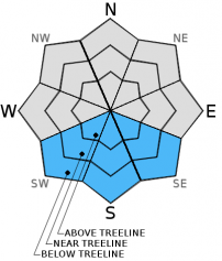
LOW avalanche danger exists this morning. As the day warms up, some pockets of MODERATE danger may form on sun-exposed SE-S-SW aspects steeper than 35 degrees up to 9500 ft. due to the possibility of some small loose wet snow instabilities like pinwheels, roller-balls, and point release avalanches. Most of these loose wet snow instabilities should remain small and isolated, but a few could entrain enough snow to create issues for backcountry travelers on slopes that experience the most warming. 

2. Moderate

?

Above Treeline
Heightened avalanche conditions on specific terrain features. Evaluate snow and terrain carefully; identify features of concern.

2. Moderate

?

Near Treeline
Heightened avalanche conditions on specific terrain features. Evaluate snow and terrain carefully; identify features of concern.

2. Moderate

?

Below Treeline
Heightened avalanche conditions on specific terrain features. Evaluate snow and terrain carefully; identify features of concern.
    Heightened avalanche conditions on specific terrain features. Evaluate snow and terrain carefully; identify features of concern.
Avalanche Problem 1: Loose Wet
  • Type ?
  • Aspect/Elevation ?
  • Likelihood ?
    Certain
    Very Likely
    Likely
    Possible
    Unlikely
  • Size ?
    Historic
    Very Large
    Large
    Small

Warmer overnight temperatures should mean a weaker overnight refreeze for the snowpack. Today's warm temperatures and sunny skies will cause this weaker refreeze to thaw more quickly, and some loose wet snow instabilities may form on the sun-exposed SE-S-SW aspects. Most of the loose wet snow instabilities should manifest as pinwheels, roller balls, and point release avalanches (sluffs). They should remain small and isolated since the snowpack has already been through several melt-freeze cycles this week and since the Feb. sun remains relatively low in the sky. However, a few of these instabilities could entrain enough snow to cause issues for backcountry travelers in isolated areas or extreme terrain. As the snowpack continues to melt and refreeze, these wet snow instabilities will continue to decrease in size, distribution, and likelihood. 

recent observations

Yesterday observations from Mt. Judah and Silver Peak both showed melt freeze crusts sitting above cold dry snow on the sun exposed SE-S-SW aspects. By midday the crusts had melted, and some small loose wet snow instabilities had started to form in the most sun exposed areas. On shaded northerly aspects, cold soft snow still existed on the surface in near and below treeline terrain sheltered from the winds. In near and above treeline areas exposed to the winds, a mix of scoured crusts, firm wind packed snow, and other wind sculpted features existed on the surface. Observations, ski cuts, and snowpit tests on the northerly aspects showed a well bonded snowpack and did not reveal any signs of instability on those aspects

Weather and CURRENT CONDITIONS
weather summary

High pressure over the forecast area will keep the weather calm, sunny, and dry. Some upper elevation sensors already reported above freezing temperatures as of 6 am this morning. Daytime highs should continue to warm with today's highs in the mid 40's above 7000 ft, and tomorrow's highs in the upper 40's above 7000 ft. The cloud cover scattered across the area this morning should clear by this afternoon. The forecast calls for light southwest winds today that shift to the north and east tonight and tomorrow. 

CONDITIONS ALONG THE SIERRA CREST BETWEEN 8200 FT. AND 9200 FT. IN THE LAST 24 HOURS
6am temperature: 30 to 36 deg. F.
Max. temperature: 37 to 43 deg. F.
Average ridgetop wind direction: Southwest and west
Average ridgetop wind speed: 10 to 20 mph
Maximum ridgetop wind gust: 41 mph
New snowfall: 0 inches
Total snow depth: 69 to 88 inches
Two-Day Mountain Weather Forecast Produced in partnership with the Reno NWS
For 7000 ft. to 8000 ft.
Saturday Saturday Night Sunday
Weather: Partly cloudy in the morning becoming sunny this afternoon Clear Sunny
Temperatures: 40 to 47 deg. F. 18 to 26 deg. F. 44 to 51 deg. F.
Mid Slope Winds: Southwest Variable Variable
Wind Speed: 10 to 15 mph in the morning decreasing in the afternoon Light Light
Expected snowfall: 0 0 0
For 8000 ft. to 9000 ft.
Saturday Saturday Night Sunday
Weather: Partly cloudy in the morning becoming sunny this afternoon Clear Sunny
Temperatures: 37 to 44 deg. F. 17 to 24 deg. F. 41 to 48 deg. F.
Ridge Top Winds: Southwest Northeast East
Wind Speed: 15 to 25 mph with gusts to 35 mph 15 to 20 mph with gusts to 30 mph 15 to 20 mph with gusts to 30 mph
Expected snowfall: 0 0 0
Disclaimer

This avalanche advisory is provided through a partnership between the Tahoe National Forest and the Sierra Avalanche Center. This advisory covers the Central Sierra Nevada Mountains between Yuba Pass on the north and Ebbetts Pass on the south. Click here for a map of the forecast area. This advisory applies only to backcountry areas outside established ski area boundaries. This advisory describes general avalanche conditions and local variations always occur. This advisory expires 24 hours after the posted time unless otherwise noted. The information in this advisory is provided by the USDA Forest Service who is solely responsible for its content.