THIS AVALANCHE FORECAST EXPIRED ON April 24, 2020 @ 6:55 am
Avalanche Forecast published on April 23, 2020 @ 6:55 am
Issued by Steve Reynaud - Tahoe National Forest

Above freezing overnight temperatures along with mostly clear skies will provide a weak refreeze of the snow surface.  Rapid warming starting early this morning will make loose wet avalanches and cornice fall avalanche problems for today.  MODERATE avalanche danger will exist at all elevations.

2. Moderate

?

Above Treeline
Heightened avalanche conditions on specific terrain features. Evaluate snow and terrain carefully; identify features of concern.

2. Moderate

?

Near Treeline
Heightened avalanche conditions on specific terrain features. Evaluate snow and terrain carefully; identify features of concern.

2. Moderate

?

Below Treeline
Heightened avalanche conditions on specific terrain features. Evaluate snow and terrain carefully; identify features of concern.
    Heightened avalanche conditions on specific terrain features. Evaluate snow and terrain carefully; identify features of concern.
Avalanche Problem 1: Loose Wet
  • Type ?
  • Aspect/Elevation ?
  • Likelihood ?
    Certain
    Very Likely
    Likely
    Possible
    Unlikely
  • Size ?
    Historic
    Very Large
    Large
    Small

Above freezing overnight temperatures with mostly clear skies should have allowed radiational cooling to provide a weak refreeze of the snow surface.  Rapid warming will quickly melt through this snow surface crust and weaken bonds starting early this morning.  E-SE-S aspects will melt the quickest, followed by varied rates on SW-W-NW-N-NE aspects.  Loose wet avalanches will become possible as the snow becomes wet and deep. 

Avoid avalanche terrain once it becomes unsupportable.  Monitor snow surface conditions while in the backcountry .  Once it becomes wet and deep, it's time to change aspects or call it a day. 

Avalanche Problem 2: Cornice
  • Type ?
  • Aspect/Elevation ?
  • Likelihood ?
    Certain
    Very Likely
    Likely
    Possible
    Unlikely
  • Size ?
    Historic
    Very Large
    Large
    Small

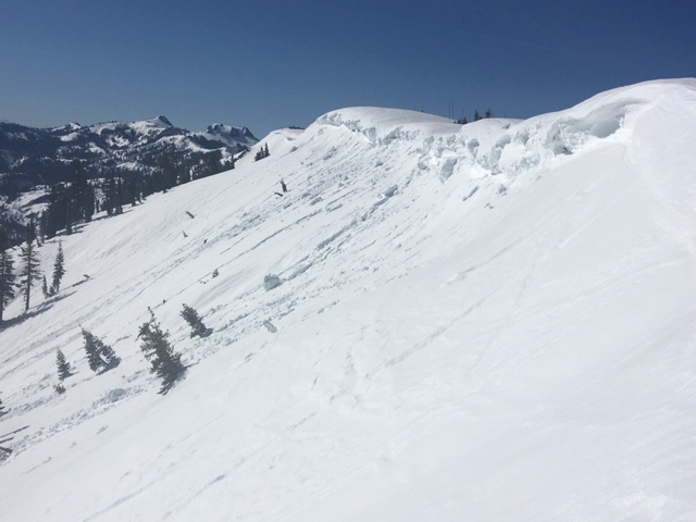
A weak overnight refreeze with rapid warming today could allow for additional cornice fall to occur.  Large cornices can be destructive by themselves and could additionally cause loose wet or wet slab avalanches to occur on the slopes below. 

Avoid areas below large cornices.  Stay well back from the edge of cornices along ridgelines and avoid any large cracks that are developing on the backside of cornices.

   Photo:  Small cornice fall along Mt. Judah, Donner Summit area.


recent observations

Observations were received yesterday from Forestdale (Carson Pass area).  A better than expected snow surface refreeze occurred with supportable riding conditions until 1:30pm.  Large cornices overhang many slopes throughout this terrain.

Observations from Mt. Judah (Donner Summit area) showed a short window for supportable conditions on sun exposed slopes.  By 9:30am, E aspects below 7600' were deep, wet, and unsupportable.  Many loose wet avalanches and cornice fall have occurred in this area over the last few days.

Weather and CURRENT CONDITIONS
weather summary

Sunny skies will continue through the weekend.  Temperatures are expected to be around 10 degrees above normal with light to moderate W to NW winds.  Remote sensors throughout the forecast region are reporting mid 30's to low 40's for overnight low temperatures with only a couple locations reaching the low 30 degree mark.  A warming trend continues with very warm temperatures possible for next week.

CONDITIONS ALONG THE SIERRA CREST BETWEEN 8200 FT. AND 9200 FT. IN THE LAST 24 HOURS
6am temperature: 33 to 40 deg. F.
Max. temperature: 44 to 54 deg. F.
Average ridgetop wind direction: W
Average ridgetop wind speed: 15 to 35 mph
Maximum ridgetop wind gust: 53 mph
New snowfall: 0 inches
Total snow depth: 47 to 73 inches
Two-Day Mountain Weather Forecast Produced in partnership with the Reno NWS
For 7000 ft. to 8000 ft.
Thursday Thursday Night Friday
Weather: Sunny. Snow levels 9000 feet. Chance of precipitation is 0%. Clear. Snow levels 9500 feet. Chance of precipitation is 0%. Sunny. Snow levels 9500 feet. Chance of precipitation is 0%.
Temperatures: 54 to 60. deg. F. 33 to 38. deg. F. 57 to 63. deg. F.
Mid Slope Winds: Light winds. Light winds. Light winds.
Expected snowfall: No accumulation. | SWE = none. No accumulation. | SWE = none. No accumulation. | SWE = none.
For 8000 ft. to 9000 ft.
Thursday Thursday Night Friday
Weather: Sunny. Snow levels 9000 feet. Chance of precipitation is 0%. Clear. Snow levels 9500 feet. Chance of precipitation is 0%. Sunny. Snow levels 9500 feet. Chance of precipitation is 0%.
Temperatures: 47 to 55. deg. F. 30 to 35. deg. F. 48 to 56. deg. F.
Ridge Top Winds: Northwest around 15 mph with gusts to 30 mph. Northwest around 15 mph in the evening becoming light. Gusts up to 30 mph. West around 15 mph with gusts to 30 mph.
Expected snowfall: No accumulation. | SWE = none. No accumulation. | SWE = none. No accumulation. | SWE = none.
Disclaimer

This avalanche forecast is provided through a partnership between the Tahoe National Forest and the Sierra Avalanche Center. This forecast covers the Central Sierra Nevada Mountains between Yuba Pass on the north and Ebbetts Pass on the south. Click here for a map of the forecast area. This forecast applies only to backcountry areas outside established ski area boundaries. This forecast describes general avalanche conditions and local variations always occur. This forecast expires 24 hours after the posted time unless otherwise noted. The information in this forecast is provided by the USDA Forest Service who is solely responsible for its content.

For a recorded version of the avalanche forecast call (530) 587-3558 x258