THIS AVALANCHE FORECAST EXPIRED ON April 10, 2020 @ 7:00 am
Avalanche Forecast published on April 9, 2020 @ 7:00 am
Issued by Steve Reynaud - Tahoe National Forest

Elevated avalanche conditions continue with wind slab, persistent slab, and loose wet avalanche problems.  Human triggered avalanches remain possible today.  MODERATE avalanche danger exists at all elevations.

2. Moderate

?

Above Treeline
Heightened avalanche conditions on specific terrain features. Evaluate snow and terrain carefully; identify features of concern.

2. Moderate

?

Near Treeline
Heightened avalanche conditions on specific terrain features. Evaluate snow and terrain carefully; identify features of concern.

2. Moderate

?

Below Treeline
Heightened avalanche conditions on specific terrain features. Evaluate snow and terrain carefully; identify features of concern.
    Heightened avalanche conditions on specific terrain features. Evaluate snow and terrain carefully; identify features of concern.
Avalanche Problem 1: Wind Slab
  • Type ?
  • Aspect/Elevation ?
  • Likelihood ?
    Certain
    Very Likely
    Likely
    Possible
    Unlikely
  • Size ?
    Historic
    Very Large
    Large
    Small

Strong to gale force NE winds are forecasted to continue through today.  Wind slabs will remain a problem on SE-S-SW-W-NW-N aspects in near and above treeline areas.  A skier triggered wind slab avalanche yesterday measured up to 3 feet deep in size.  These wind slabs are expected to remain reactive today.

Look for blowing snow, wind scoured areas, wind pillows, and newer cornice formation to help identify what slopes are being wind loaded.  Solar radiation and additional warming may increase instability on these newly formed wind slabs.  Large cornices that were built out during the storm may become weaker with increased warming today. 

   Skier triggered D1 wind slab avalanche on Mt. Tallac.

Avalanche Problem 2: Persistent Slab
  • Type ?
  • Aspect/Elevation ?
  • Likelihood ?
    Certain
    Very Likely
    Likely
    Possible
    Unlikely
  • Size ?
    Historic
    Very Large
    Large
    Small

Concern continues for a persistent slab avalanche problem on NW-N-NE-E aspects at all elevations.  Avalanches have failed on the old snow surface crust which is now buried 1 to 3 feet deep below the snow surface.  Another potential persistent slab avalanche was skier triggered yesterday on Relay Peak in the Mt. Rose area.  Details are limited, but this avalanche does have some of the same characteristics of the other persistent slab avalanches.  Observations in other areas throughout the forecast region suggest that this layer has gained strength.  While this weak layer may be isolated throughout our area, pockets of instabilities still continue to exist. 

Avalanches associated with this problem could be large, propagate wide, and be remotely triggered.  It is very difficult to know exactly where this weak layer exists and is problematic.  Avoidance is a repeatable backcountry strategy where you either don't go on the aspects of concern or stay under 30 degrees in steepness with no steeper connected terrain above or to the side.

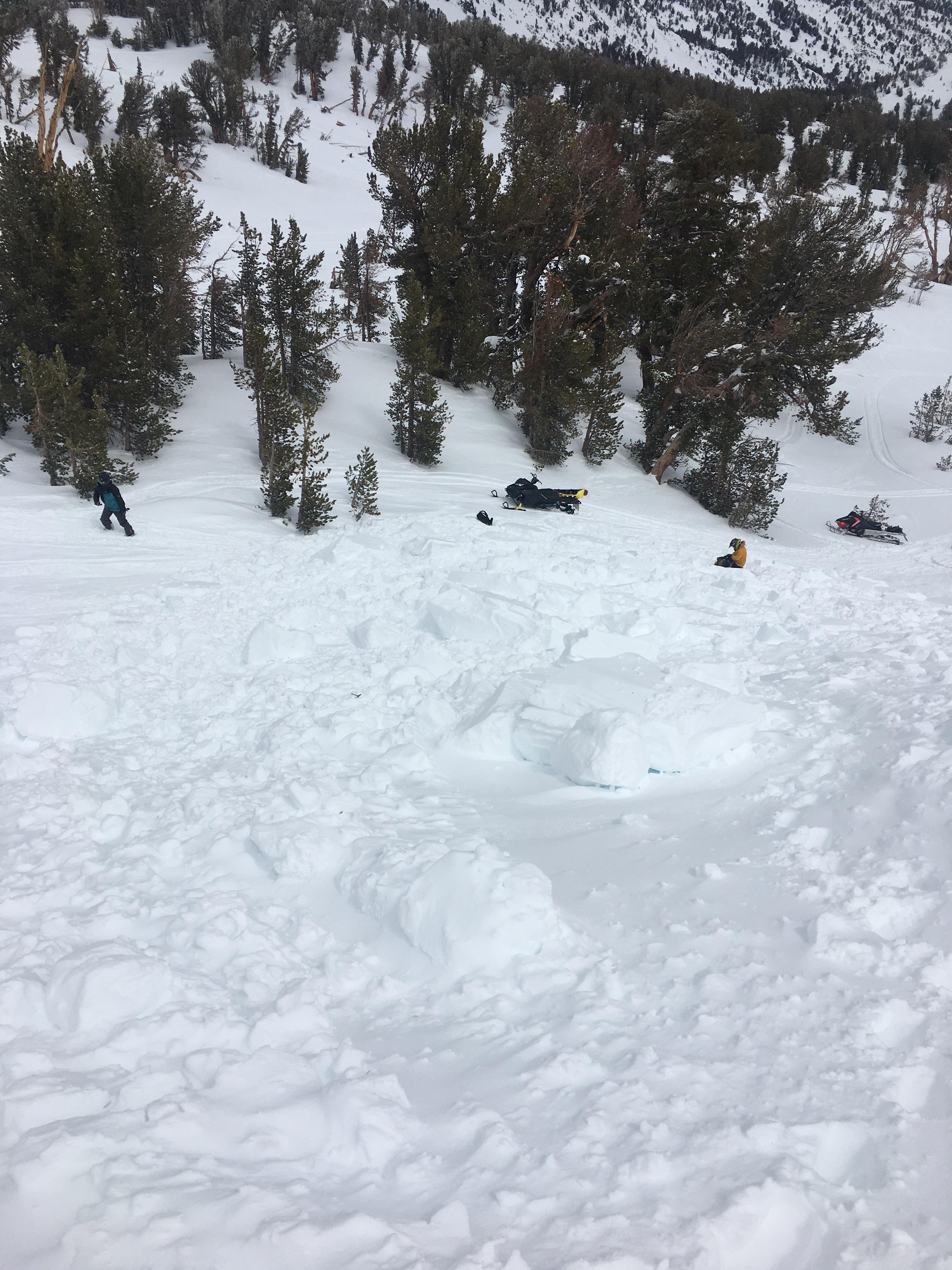
  Skier triggered avalanche yesterday on Relay Peak.

Avalanche Problem 3: Loose Wet
  • Type ?
  • Aspect/Elevation ?
  • Likelihood ?
    Certain
    Very Likely
    Likely
    Possible
    Unlikely
  • Size ?
    Historic
    Very Large
    Large
    Small

Warm overnight temperatures with periods of sunshine today will allow for loose wet avalanches to form on all wind protected aspects and elevations.  Areas that receive light rain today will see an increase in loose wet avalanche activity.  While wind exposed areas should limit some of the warming today, loose wet avalanches could occur in wind protected higher elevation terrain.  Roller balls and pinwheels will be indications that larger loose wet avalanches could occur.  Loose wet avalanches could increase your risk of being pushed into rocks, trees, and over cliffs. 

recent observations

A group of skiers were caught in a wind slab avalanche on Mt. Tallac in the North Bowl.  3 skiers were caught with 1 taking a ride for 500'.  The wind slab avalanche crown was up to 3 feet deep.

A skier accidentally triggered an avalanche on Relay Peak on a NE aspect around 9500'.  Another group responded to the avalanche and potential burial-with no one was injured.  This avalanche was reported as a wind slab, but it is thought that it could have been a persistent slab avalanche.  

Loose wet avalanche activity was reported from several locations throughout the forecast region. 

Weather and CURRENT CONDITIONS
weather summary

Warm overnight temperatures with most remote sensors reporting mid 30's to low 40's.  Bands of rain and higher elevation snow will be possible today throughout the Tahoe Basin with areas south of Hwy. 50 expecting more precipitation today.  Snow levels could vary between 7000-8000'.  Gusty NE winds will continue today and tonight.  This disturbance should clear out tonight with a warming trend and clearing skies starting on Friday. 

CONDITIONS ALONG THE SIERRA CREST BETWEEN 8200 FT. AND 9200 FT. IN THE LAST 24 HOURS
6am temperature: 27 to 38 deg. F.
Max. temperature: 35 to 45 deg. F.
Average ridgetop wind direction: E to NE
Average ridgetop wind speed: 15 to 45 mph
Maximum ridgetop wind gust: 70 mph
New snowfall: 0 to trace inches
Total snow depth: 68 to 89 inches
Two-Day Mountain Weather Forecast Produced in partnership with the Reno NWS
For 7000 ft. to 8000 ft.
Thursday Thursday Night Friday
Weather: Mostly cloudy. Chance of showers. Snow levels 7500 feet. Chance of precipitation is 60%. Mostly cloudy then becoming partly cloudy. Chance of showers in the evening, then chance of snow showers after midnight. Snow levels 8000 feet decreasing to 7000 feet after midnight. Chance of precipitation is 40%. Partly cloudy then becoming sunny. Snow levels below 7000 feet increasing to 8000 feet in the afternoon. Chance of precipitation is 5%.
Temperatures: 39 to 47. deg. F. 24 to 30. deg. F. 46 to 52. deg. F.
Mid Slope Winds: Light winds becoming northeast around 15 mph in the afternoon. North around 15 mph in the evening becoming light. Gusts up to 25 mph. Light winds.
Expected snowfall: 40% probability 1-2 inches. 60% probability up to 3 inches. | SWE = up to 0.20 inch. 60% probability up to 2 inches. 40% probability no accumulation. | SWE = up to 0.15 inch. No accumulation. | SWE = none.
For 8000 ft. to 9000 ft.
Thursday Thursday Night Friday
Weather: Mostly cloudy. Snow showers likely in the morning, then chance of showers in the afternoon. Snow levels 7500 feet. Chance of precipitation is 65%. Mostly cloudy then becoming partly cloudy. Chance of showers in the evening, then chance of snow showers after midnight. Snow levels 7500 feet. Chance of precipitation is 45%. Sunny. Snow levels below 7000 feet increasing to 8000 feet in the afternoon. Chance of precipitation is 5%.
Temperatures: 33 to 41. deg. F. 21 to 27. deg. F. 40 to 46. deg. F.
Ridge Top Winds: Northeast 20 to 35 mph with gusts to 65 mph. North 15 to 30 mph with gusts to 65 mph. North 15 to 20 mph with gusts to 35 mph.
Expected snowfall: 60% probability of 1 to 3 inches. 40% probability less than 1 inch. | SWE = up to 0.25 inch. 60% probability up to 2 inches. 40% probability no accumulation. | SWE = up to 0.15 inch. No accumulation. | SWE = none.
Disclaimer

This avalanche forecast is provided through a partnership between the Tahoe National Forest and the Sierra Avalanche Center. This forecast covers the Central Sierra Nevada Mountains between Yuba Pass on the north and Ebbetts Pass on the south. Click here for a map of the forecast area. This forecast applies only to backcountry areas outside established ski area boundaries. This forecast describes general avalanche conditions and local variations always occur. This forecast expires 24 hours after the posted time unless otherwise noted. The information in this forecast is provided by the USDA Forest Service who is solely responsible for its content.

For a recorded version of the avalanche forecast call (530) 587-3558 x258