THIS AVALANCHE FORECAST EXPIRED ON January 23, 2020 @ 7:00 am
Avalanche Forecast published on January 22, 2020 @ 7:00 am
Issued by Steve Reynaud - Tahoe National Forest

Human triggered avalanches remain possible today with potential high consequences.  MODERATE avalanche danger exists with possible wind slabs and persistent slab avalanche problems.


2. Moderate

?

Above Treeline
Heightened avalanche conditions on specific terrain features. Evaluate snow and terrain carefully; identify features of concern.

2. Moderate

?

Near Treeline
Heightened avalanche conditions on specific terrain features. Evaluate snow and terrain carefully; identify features of concern.

2. Moderate

?

Below Treeline
Heightened avalanche conditions on specific terrain features. Evaluate snow and terrain carefully; identify features of concern.
    Heightened avalanche conditions on specific terrain features. Evaluate snow and terrain carefully; identify features of concern.
Avalanche Problem 1: Wind Slab
  • Type ?
  • Aspect/Elevation ?
  • Likelihood ?
    Certain
    Very Likely
    Likely
    Possible
    Unlikely
  • Size ?
    Historic
    Very Large
    Large
    Small

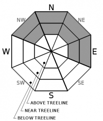
In near and above treeline terrain that received the most storm snow yesterday, we will have up to size D2 wind slab avalanches possible today.  Winds have been elevated into the strong to gale force range in the higher terrain over the last 36 hours with locations along the Sierra Crest receiving up to 5'' of storm snow yesterday.  High winds will continue today before decreasing this afternoon.  Newly formed wind slabs will exist and could be human triggered today.

Look for signs of wind loading: blowing snow, built out cornices, wind scouring along ridges, and wind pillows.  Cornices and wind slabs could be reactive to the weight of a backcountry user.

Avalanche Problem 2: Persistent Slab
  • Type ?
  • Aspect/Elevation ?
  • Likelihood ?
    Certain
    Very Likely
    Likely
    Possible
    Unlikely
  • Size ?
    Historic
    Very Large
    Large
    Small

Large and destructive avalanches remain possible failing on a weak layer of snow buried 2’ deep or more beneath the snow surface.  The Jan 4 weak layer has been showing signs of gaining strength and adjusting to the load of recent storm snow.  Snowpack tests and informal observations have shown improvement with no avalanche activity reported for the last 2-3 days.  While it is becoming harder to trigger this persistent slab, the consequences remain high.  Avalanches associated with this weak layer would be large avalanche events. 

The places that would be most likely to trigger this weak layer would be:  complex terrain, convex slopes, and shallower snowpack area.  Remote triggering a persistent slab avalanche or a persistent slab avalanche occurring on a slope that has been previously tracked out remain possible.  Assess slopes before you commit to them.  Talk about consequences with your group and discuss what would happen if an avalanche were to occur.  Avoidance continues to be the best strategy to address persistent weak layers.  Pick a aspect where the problem doesn't exist, or ski slopes below 30 degrees with no overhead hazard.

recent observations

Observations were submitted from Donner Ridge (Donner Summit area), Elephants Hump (Carson Pass area), and Upper Deep Creek.  Many snowpack tests targeting the Jan 4 weak layer were conducted.  While the facets below the Jan 4 rain crust still exist, they are gaining strength and adjusting to the load of the recent storm slab.  Many ECT's and PST's targeting this layer indicated that propagation was not likely.

Persistent slab avalanches have not been reported since Sunday.

Moderate wind transport was observed on Elephants Hump with strong to gale force SW winds moving moderate amounts of existing snow.

Weather and CURRENT CONDITIONS
weather summary

The weak storm that moved through our area yesterday brought strong to gale force winds with  0 to 5'' of new snow.  Cloudy skies today with mostly dry conditions, decreasing winds, and warming temperatures into Thursday.  A weak and warmer storm is possible for Thursday night into Friday morning.  This storm has limited moisture with snow levels looking to be around 6500-7500'.  A splitting storm is possible for Sunday to Monday, but at this point confidence is low in storm potential. 

CONDITIONS ALONG THE SIERRA CREST BETWEEN 8200 FT. AND 9200 FT. IN THE LAST 24 HOURS
6am temperature: 24 to 31 deg. F.
Max. temperature: 25 to 32 deg. F.
Average ridgetop wind direction: SW
Average ridgetop wind speed: 35 to 60 mph
Maximum ridgetop wind gust: 91 mph
New snowfall: 1 to 4 inches
Total snow depth: 46 to 51 inches
Two-Day Mountain Weather Forecast Produced in partnership with the Reno NWS
For 7000 ft. to 8000 ft.
Wednesday Wednesday Night Thursday
Weather: Mostly cloudy. Slight chance of snow in the morning. Snow levels below 7000 feet. Chance of precipitation is 10%. Mostly cloudy then becoming partly cloudy. Snow levels 7000 feet. Chance of precipitation is 0%. Partly cloudy then becoming mostly cloudy. Slight chance of rain and snow in the afternoon. Snow levels below 7000 feet increasing to 7500 feet in the afternoon. Chance of precipitation is 10%.
Temperatures: 38 to 43. deg. F. 20 to 25. deg. F. 40 to 45. deg. F.
Mid Slope Winds: Southwest around 15 mph with gusts to 45 mph in the morning becoming light. Light winds. Light winds.
Expected snowfall: No accumulation. | SWE = none. No accumulation. | SWE = none. No accumulation. | SWE = none.
For 8000 ft. to 9000 ft.
Wednesday Wednesday Night Thursday
Weather: Mostly cloudy. Slight chance of snow in the morning. Snow levels below 7000 feet increasing to 7000 feet in the afternoon. Chance of precipitation is 10%. Mostly cloudy then becoming partly cloudy. Snow levels 7000 feet. Chance of precipitation is 0%. Partly cloudy then becoming mostly cloudy. Slight chance of snow in the afternoon. Snow levels below 7000 feet increasing to 7500 feet in the afternoon. Chance of precipitation is 10%.
Temperatures: 32 to 36. deg. F. 19 to 24. deg. F. 37 to 43. deg. F.
Ridge Top Winds: Southwest 25 to 35 with gusts up to 70 mph in the morning becoming west 15 to 30 mph with gusts to 45 mph. West around 15 mph with gusts to 30 mph. Southwest around 15 mph in the morning becoming light.
Expected snowfall: No accumulation. | SWE = none. No accumulation. | SWE = none. No accumulation. | SWE = none.
Disclaimer

This avalanche forecast is provided through a partnership between the Tahoe National Forest and the Sierra Avalanche Center. This forecast covers the Central Sierra Nevada Mountains between Yuba Pass on the north and Ebbetts Pass on the south. Click here for a map of the forecast area. This forecast applies only to backcountry areas outside established ski area boundaries. This forecast describes general avalanche conditions and local variations always occur. This forecast expires 24 hours after the posted time unless otherwise noted. The information in this forecast is provided by the USDA Forest Service who is solely responsible for its content.

For a recorded version of the avalanche forecast call (530) 587-3558 x258