THIS AVALANCHE FORECAST EXPIRED ON November 21, 2020 @ 6:53 am
Avalanche Forecast published on November 20, 2020 @ 6:53 am
Issued by Steve Reynaud - Tahoe National Forest

Wind slab and persistent slab avalanche problems remain possible throughout the forecast area.  Early season conditions exist with a shallow snowpack and many obstacles.  Use extra caution if traveling in the backcountry with thin snowpack conditions.

2. Moderate

?

Above Treeline
Heightened avalanche conditions on specific terrain features. Evaluate snow and terrain carefully; identify features of concern.

2. Moderate

?

Near Treeline
Heightened avalanche conditions on specific terrain features. Evaluate snow and terrain carefully; identify features of concern.

2. Moderate

?

Below Treeline
Heightened avalanche conditions on specific terrain features. Evaluate snow and terrain carefully; identify features of concern.
    Heightened avalanche conditions on specific terrain features. Evaluate snow and terrain carefully; identify features of concern.
Avalanche Problem 1: Wind Slab
  • Type ?
  • Aspect/Elevation ?
  • Likelihood ?
    Certain
    Very Likely
    Likely
    Possible
    Unlikely
  • Size ?
    Historic
    Very Large
    Large
    Small

Large dense wind slabs that formed during and after the storm may still be reactive to human triggering.  These wind slabs exist on NW-N-NE-E-SE aspects in near and above treeline terrain. 

Look for previous signs of wind loading like snow surface wind scouring, built our cornices, and wind pillows.  Large cornices may still be fragile and could break along ridglines with large chunks falling downslope.  Limit exposure time below these corniced slopes and steep wind loaded terrain. 

Avalanche Problem 2: Persistent Slab
  • Type ?
  • Aspect/Elevation ?
  • Likelihood ?
    Certain
    Very Likely
    Likely
    Possible
    Unlikely
  • Size ?
    Historic
    Very Large
    Large
    Small

The weak faceted snow that formed between the Nov 7 and Nov 13 storms continues to be a concern.  While no avalanches have been reported, this weak layer still shows unstable snowpack test results in some locations throughout the forecast area.  It has been found in below and near treeline areas on NW-N-NE aspects above 8300' along the Sierra Crest and the Mt. Rose areas and more prominent at higher elevations.

This weak layer is limited to areas that were not wind scoured by previous NE/E winds in earlier November.  Cautious travel in these specific terrain areas or sticking to slopes under 30 degrees with no overhead hazard remain good travel protocols with any persistent slab avalanche problem.  Any whumping sounds, collapsing, shooting cracks, or recent avalanches would indicate unstable snow in the immediate area. 


recent observations

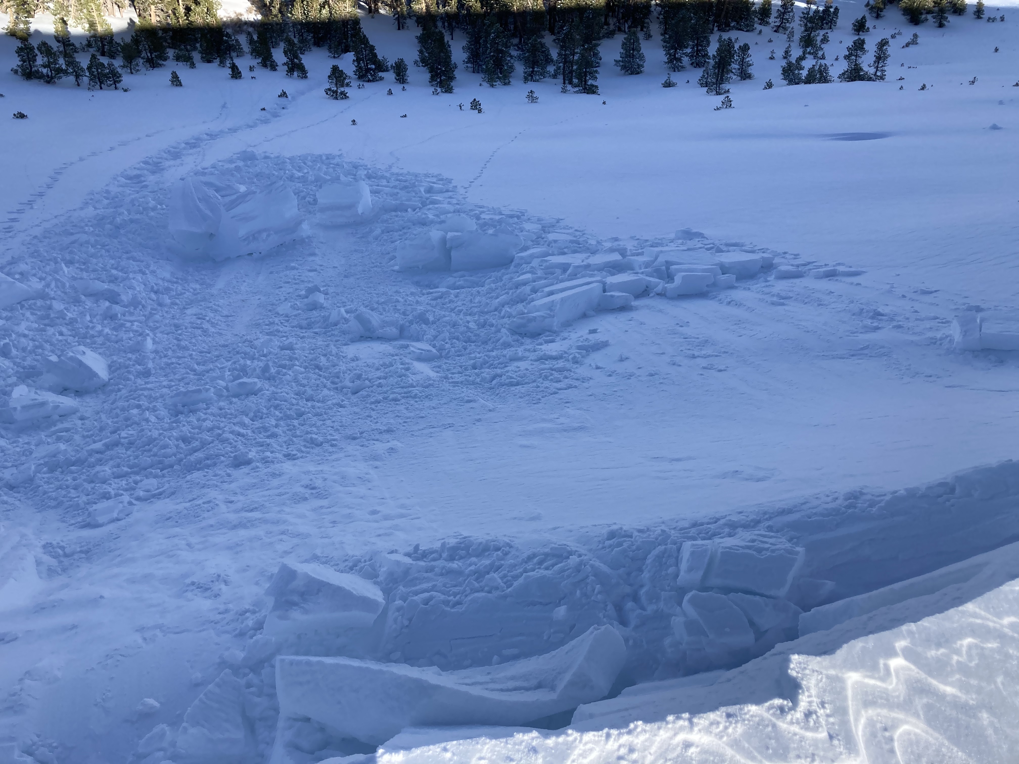
A large intentionally triggered cornice collapse occurred on Meiss Ridge in the Carson Pass area.

Unstable snowpack results on the Nov 13 facet layer were observed at Grouse Rock in the Ward Canyon area.  Snowpack tests were done at 8300' on a northerly aspect with multiple ECTP results.  Test results and observations were inconclusive at Castle Peak on Donner Summit.  The buried facet layer was reactive at 8300' on a NW aspect, but was not near 8800' on a NW aspect at higher elevation.  Other observations submitted showed the facet layer to be non-reactive or could not be found.

Early season snowpack conditions exist in the forecast area with 2-3’ of a dense snowpack above 7800’ along the Sierra Crest and above 8600’ in the Mt. Rose area.

.   

Intentional cornice collapse on Meiss Ridge.


Weather and CURRENT CONDITIONS
weather summary

Quiet weather, with light winds and mostly sunny skies, will take us into the weekend.  Cold overnight lows with inversions setting up and seasonal sunny days are forecasted.  2 weak weather systems will pass by our area next week with limited precipitation at this point.    

CONDITIONS ALONG THE SIERRA CREST BETWEEN 8200 FT. AND 9200 FT. IN THE LAST 24 HOURS
6am temperature: 22 to 30 deg. F.
Max. temperature: 32 to 34 deg. F.
Average ridgetop wind direction: SW to variable
Average ridgetop wind speed: 5 to 15 mph
Maximum ridgetop wind gust: 26 mph
New snowfall: 0 inches
Total snow depth: 18 to 22 inches
Two-Day Mountain Weather Forecast Produced in partnership with the Reno NWS
For 7000 ft. to 8000 ft.
Friday Friday Night Saturday
Weather: Partly cloudy. Snow levels below 7000 feet. Chance of precipitation is 0%. Clear. Snow levels below 7000 feet. Chance of precipitation is 0%. Sunny. Snow levels below 7000 feet. Chance of precipitation is 0%.
Temperatures: 39 to 45. deg. F. 21 to 27. deg. F. 40 to 46. deg. F.
Mid Slope Winds: Light winds. Light winds. Light winds.
Expected snowfall: No accumulation. | SWE = none. No accumulation. | SWE = none. No accumulation. | SWE = none.
For 8000 ft. to 9000 ft.
Friday Friday Night Saturday
Weather: Mostly cloudy then becoming partly cloudy. Snow levels below 7000 feet increasing to 7000 feet in the afternoon. Chance of precipitation is 0%. Clear. Snow levels below 7000 feet. Chance of precipitation is 0%. Sunny. Snow levels below 7000 feet. Chance of precipitation is 0%.
Temperatures: 35 to 41. deg. F. 21 to 26. deg. F. 36 to 42. deg. F.
Ridge Top Winds: Southwest around 15 mph with gusts up to 30 mph Southwest around 15 mph with gusts to 30 mph. Light winds.
Expected snowfall: No accumulation. | SWE = none. No accumulation. | SWE = none. No accumulation. | SWE = none.
Disclaimer

This avalanche forecast is provided through a partnership between the Tahoe National Forest and the Sierra Avalanche Center. This forecast covers the Central Sierra Nevada Mountains between Yuba Pass on the north and Ebbetts Pass on the south. Click here for a map of the forecast area. This forecast applies only to backcountry areas outside established ski area boundaries. This forecast describes general avalanche conditions and local variations always occur. This forecast expires 24 hours after the posted time unless otherwise noted. The information in this forecast is provided by the USDA Forest Service who is solely responsible for its content.

For a recorded version of the avalanche forecast call (530) 587-3558 x258