THIS AVALANCHE FORECAST EXPIRED ON January 14, 2020 @ 6:59 am
Avalanche Forecast published on January 13, 2020 @ 6:59 am
Issued by Andy Anderson - Tahoe National Forest - Sierra Avalanche Center

Continous strong SW winds have formed slabs of wind drifted snow that the weight of a person could still break on many leeward facing slopes in near and above treeline terrain. As more snow accumulates tonight, expect larger and easier to trigger wind slabs to form. MODERATE avalanche danger exists near and above treeline with LOW avalanche danger below treeline.

2. Moderate

?

Above Treeline
Heightened avalanche conditions on specific terrain features. Evaluate snow and terrain carefully; identify features of concern.

2. Moderate

?

Near Treeline
Heightened avalanche conditions on specific terrain features. Evaluate snow and terrain carefully; identify features of concern.

1. Low

?

Below Treeline
Generally safe avalanche conditions. Watch for unstable snow on isolated terrain features.
    Heightened avalanche conditions on specific terrain features. Evaluate snow and terrain carefully; identify features of concern.
Avalanche Problem 1: Wind Slab
  • Type ?
  • Aspect/Elevation ?
  • Likelihood ?
    Certain
    Very Likely
    Likely
    Possible
    Unlikely
  • Size ?
    Historic
    Very Large
    Large
    Small

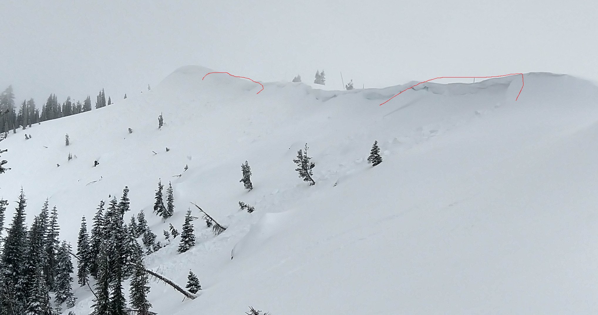
The strong SW winds continue to drift snow onto the leeward NW-N-NE-E-SE aspects. This continuous wind-loading has not given these slabs of wind drifted snow the chance to bond to the old snow below them. Human-triggered wind slab avalanches will remain possible today. In most areas, these wind slabs should remain small and may only knock a person off balance (D1). In the areas where more snow accumulated recently (like Donner Summit), they could involve enough snow to bury or injure a person (D2). As more snow starts to fall tonight, these wind slabs will become easier to trigger, more widespread, and larger in size. Large fragile cornices also exist along ridgelines across the forecast area.

Stay alert for areas where possibly unstable wind slabs may exist by looking for clues like cornices above a slope, drifted snow, scoured ridges with smooth snow on one side, and wind-created surface textures. Use this information to plan travel routes with safety margins that appropriately manage this potential hazard. 

D2 wind slabs on Mt. Judah that likely occurred on Jan 11. 

recent observations

* Strong winds and blowing snow were reported across the forecast area. Observers in the Donner Summit area noted new cornice formation and wind slab growth. Large cornices above wind loaded slopes were also reported along the Mt. Reba Ridge near Bear Valley. 

* A few D1 and D2 skier and cornice triggered wind slab avalanches have occurred in the last 2 days in the Donner Summit (ob 1 and ob 2) and Echo Summit areas.

* Weak snow (facets) still exists below the Jan 4 rain crust. This layer varies in burial depth and strength around the forecast area, In many places, tests on this layer have indicated that it may fail under a significant new snow loading event like what is expected on Wed and Thursday. 

Weather and CURRENT CONDITIONS
weather summary

A little more snow fell last night with some areas along the Sierra Crest reporting up to an inch of new snow and most places around the forecast area reporting only a trace amount of new snow. Strong SW winds accompanied this light snow with gusts reaching into the 80's along the Crest and up to 96 mph on Slide Mountain. The second in a series of progressively stronger winter storms should arrive this evening with more wind and snow. By midday tomorrow the mountains could see another 2 to 8 inches of new snow with some places along the Sierra Crest getting 6 to 10 inches. Another stronger storm should arrive Wednesday night and continue through Thursday with low snow levels, intense snowfall, and gale-force winds. For more details check in with the Reno NWS. 

CONDITIONS ALONG THE SIERRA CREST BETWEEN 8200 FT. AND 9200 FT. IN THE LAST 24 HOURS
6am temperature: 14 to 23 deg. F.
Max. temperature: 18 to 29 deg. F.
Average ridgetop wind direction: SW
Average ridgetop wind speed: 30 to 45 mph
Maximum ridgetop wind gust: 82 mph
New snowfall: Trace to 1 inches
Total snow depth: 41 to 45 inches
Two-Day Mountain Weather Forecast Produced in partnership with the Reno NWS
For 7000 ft. to 8000 ft.
Monday Monday Night Tuesday
Weather: Partly cloudy then becoming sunny. Slight chance of snow in the morning. Snow levels below 7000 feet. Chance of precipitation is 5%. Partly cloudy then becoming mostly cloudy. Slight chance of snow in the evening, then snow likely after midnight. Snow levels below 7000 feet. Chance of precipitation is 60%. Cloudy then becoming partly cloudy. Chance of snow through the day. Snow levels below 7000 feet. Chance of precipitation is 55%.
Temperatures: 30 to 36 deg. F. 20 to 25 deg. F. 27 to 32 deg. F.
Mid Slope Winds: Southwest 15 to 25 mph with gusts to 50 mph. Southwest 20 to 35 mph with gusts to 60 mph increasing to 30 to 45 mph with gusts to 90 mph after midnight. Southwest 30 to 45 mph decreasing to 20 to 30 mph in the afternoon. Gusts up to 80 mph.
Expected snowfall: 100% probability up to 1 inch. | SWE = up to 0.02 inches. 80% probability of 1 to 4 inches. 20% probability of 4 to 7 inches. | SWE = 0.15-0.25 inch. 70% probability of 1 to 3 inches. 30% probability no accumulation. | SWE = up to 0.15 inch.
For 8000 ft. to 9000 ft.
Monday Monday Night Tuesday
Weather: Partly cloudy then becoming sunny. Snow levels below 7000 feet. Chance of precipitation is 5%. Partly cloudy then becoming mostly cloudy. Chance of snow after midnight. Snow levels below 7000 feet. Chance of precipitation is 50%. Mostly cloudy then becoming partly cloudy. Chance of snow through the day. Snow levels below 7000 feet. Chance of precipitation is 50%.
Temperatures: 26 to 32 deg. F. 17 to 22 deg. F. 23 to 29 deg. F.
Ridge Top Winds: Southwest 25 to 35 mph with gusts to 60 mph. Southwest 35 to 55 mph increasing to 50 to 65 mph after midnight. Gusts up to 100 mph. Southwest 45 to 60 mph with gusts to 100 mph decreasing to 30 to 50 mph with gusts to 80 mph in the afternoon.
Expected snowfall: 100% probability up to 1 inch. | SWE = up to 0.02 inches. 80% probability of 2 to 5 inches. 20% probability of 5 to 8 inches. | SWE = up to 0.30 inch. 70% probability of 1 to 3 inches. 30% probability no accumulation. | SWE = up to 0.15 inch.
Disclaimer

This avalanche forecast is provided through a partnership between the Tahoe National Forest and the Sierra Avalanche Center. This forecast covers the Central Sierra Nevada Mountains between Yuba Pass on the north and Ebbetts Pass on the south. Click here for a map of the forecast area. This forecast applies only to backcountry areas outside established ski area boundaries. This forecast describes general avalanche conditions and local variations always occur. This forecast expires 24 hours after the posted time unless otherwise noted. The information in this forecast is provided by the USDA Forest Service who is solely responsible for its content.

For a recorded version of the avalanche forecast call (530) 587-3558 x258